Mount Airy, Georgia facts for kids
Quick facts for kids
Mount Airy, Georgia
|
|
|---|---|

Mount Airy Town Hall
|
|

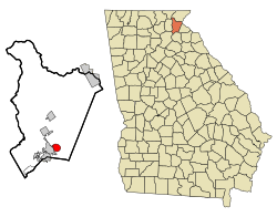
Location in Habersham County and the state of Georgia
|
|
| Country | United States |
| State | Georgia |
| County | Habersham |
| Area | |
| • Total | 2.42 sq mi (6.28 km2) |
| • Land | 2.42 sq mi (6.26 km2) |
| • Water | 0.01 sq mi (0.02 km2) |
| Elevation | 1,453 ft (443 m) |
| Population
(2020)
|
|
| • Total | 1,391 |
| • Density | 575.98/sq mi (222.37/km2) |
| Time zone | UTC-5 (Eastern (EST)) |
| • Summer (DST) | UTC-4 (EDT) |
| ZIP code |
30563
|
| Area code(s) | 706 |
| FIPS code | 13-53284 |
| GNIS feature ID | 2406203 |
Mount Airy is a small town located in Habersham County, Georgia, in the United States. In 2020, about 1,391 people lived there. The town has grown quite a bit, as only 604 people lived there in 2000.
Contents
A Look Back: Mount Airy's History
Mount Airy became an official town in 1874. This means the state government, called the Georgia General Assembly, gave it the power to govern itself. The town's name might describe its location, or it could have been named after another place called Mount Airy in North Carolina.
A famous historic house called Lawton Place is in Mount Airy. It was once home to Ty Cobb, a legendary baseball player. This house is now listed on the National Register of Historic Places.
Exploring Mount Airy's Geography
Mount Airy is found in the southern part of Habersham County. It shares a border with the city of Cornelia to the west. To the south, you'll find the Chattahoochee National Forest.
The town sits right on top of the Eastern Continental Divide. This is like a high ridge where rainfall on one side flows to the Atlantic Ocean, and rain on the other side flows to the Gulf of Mexico.
- Water from the northern part of Mount Airy flows into Camp Creek. This water eventually reaches the Chattahoochee River and then the Gulf of Mexico.
- Water from the southern part of town flows into Nancy Town Creek. This water eventually joins the Savannah River and flows into the Atlantic Ocean.
The town covers about 2.42 square miles (6.28 square kilometers) of land. Only a tiny part, about 0.01 square miles (0.02 square kilometers), is water.
Mount Airy is also quite high up! It's about 1,453 feet (469 meters) above sea level. A special marker near the City Hall confirms that it's the highest point on the Southern Railway line between New Orleans and Washington, D.C..
Who Lives in Mount Airy: Population Facts
The number of people living in Mount Airy has changed a lot over the years. Here's a quick look at how the population has grown:
| Historical population | |||
|---|---|---|---|
| Census | Pop. | %± | |
| 1880 | 112 | — | |
| 1890 | 201 | 79.5% | |
| 1900 | 310 | 54.2% | |
| 1910 | 256 | −17.4% | |
| 1920 | 343 | 34.0% | |
| 1930 | 354 | 3.2% | |
| 1940 | 437 | 23.4% | |
| 1950 | 416 | −4.8% | |
| 1960 | 417 | 0.2% | |
| 1970 | 463 | 11.0% | |
| 1980 | 670 | 44.7% | |
| 1990 | 543 | −19.0% | |
| 2000 | 604 | 11.2% | |
| 2010 | 1,284 | 112.6% | |
| 2020 | 1,391 | 8.3% | |
| U.S. Decennial Census | |||
In 2000, there were 604 people living in Mount Airy. These people lived in 235 households. Many of these households (about 58.7%) were married couples living together. About 30.6% of households had children under 18.
The average household had about 2.57 people. The average family had about 2.95 people.
The population was spread out in terms of age. About 23.2% of the people were under 18 years old. About 14.4% were 65 years or older. The average age in the town was 38 years old.
See also
 In Spanish: Mount Airy (Georgia) para niños
 | Claudette Colvin |
 | Myrlie Evers-Williams |
 | Alberta Odell Jones |

