Mount Barney (Queensland) facts for kids
Quick facts for kids Mount Barney |
|
|---|---|

Mount Barney
|
|
| Highest point | |
| Elevation | 1,359 m (4,459 ft) |
| Listing | Mountains in Australia |
| Geography | |
| Location | Queensland, Australia |
| Parent range | McPherson Range |
| Peaks | West Peak (1359), East Peak (1354), North Pinnacle (1221), Leaning Peak, Isolated Peak, Toms Tum, Midget Peak, Barrabool Peak |
| Geology | |
| Age of rock | 24 million years |
| Mountain type | Shield volcano |
| Climbing | |
| First ascent | 3 August 1828 by Captain Patrick Logan |
| Easiest route | Peasants Ridge (South Ridge) |
| Normal route | South (Peasants) Ridge, Mezzanine Ridge, Lions Ridge, South East Ridge, Mid South East Ridge, Logans Ridge, Rocky Creek, North Ridge, Northeast Ridge, Eagles Ridge, Short Leaning Route, Long Leaning Route, Midgets Route, Savages Ridge |
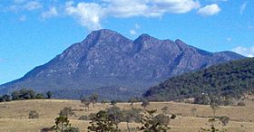
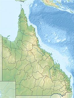
Mount Barney is a tall mountain in the Scenic Rim Region of Queensland, Australia. It is about 130 kilometers (80 miles) south-west of Brisbane. The mountain is close to the border with New South Wales. It is part of the McPherson Range.
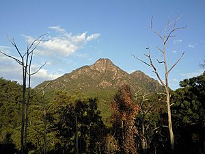
Many people love to visit Mount Barney for bushwalking and camping. It is one of Queensland's highest mountains. It is also seen as one of the most amazing parts of the Scenic Rim area. Mount Barney has two main peaks: East Peak and West Peak. West Peak is a little taller. There are also several smaller peaks. East Peak is very popular with bushwalkers.
The closest town to Mount Barney is Rathdowney. Other mountains like Mount Ballow, Mount May, and Mount Lindesay are nearby. The Logan River actually starts on Mount Barney.
Contents
How Mount Barney Formed
Mount Barney is made of a special rock called granophyre. This rock formed deep underground. It pushed its way into the sandstone above it. Over millions of years, wind and rain wore away the softer sandstone. This left behind the harder granophyre, forming the mountain's two peaks.
Mount Barney is what's left of a huge ancient volcano called the Focal Peak Volcano. This volcano, along with the Tweed Volcano, once covered a large area. They spread lava across much of South East Queensland and North East New South Wales.
Amazing Nature and Wildlife
In 1947, the Mount Barney National Park was created. This park helps protect the special plants and animals around the mountain. Mount Barney is also part of the Gondwana Rainforests of Australia. These rainforests are a World Heritage Site. This means they are very important globally.
You can find special trees like the Antarctic beech on nearby Mount Nothafagus and Mount Ballow. Many interesting animals live on the mountain. These include platypus, rock wallabies, and Coxen's fig parrot. The heath plants on the mountain are home to the eastern bristlebird. This bird is endangered, meaning it is at risk of disappearing forever.
Mount Barney's History
Mount Barney has been very important to local Aboriginal people for thousands of years. It appears in many of their traditional stories. For Aboriginal people, the mountain was often seen as a place to respect and sometimes avoid.
In 1828, an explorer named Allan Cunningham first called the mountain Mount Lindesay. Later, in the 1840s, Surveyor-General Thomas Mitchell renamed it Mount Barney. He named it after George Barney, who was an engineer in the colony. Mitchell then gave the name Mount Lindesay to the mountain we know by that name today.
The first European to climb Mount Barney was Captain Patrick Logan. He reached the East Peak summit in 1828. He climbed up what is now called Logan's Ridge. Two botanists, Charles Fraser and Allan Cunningham, wrote about the climb. They were with Logan for part of his journey.
Europeans likely started hiking at Mount Barney for fun around the 1880s. This was when more people settled in the area. By the early 1900s, a few 'mountaineers' began exploring the peak. These included teachers Harry Johns and William Gaylard. However, it wasn't until the 1930s that more people started visiting. Groups like the National Parks Association formed. New adventurers like Bert Salmon and Arthur Groom explored the mountain. Even then, much of Mount Barney remained a mystery until the late 1940s and early 1950s. At that time, groups like the University of Queensland Bushwalking Club started regular trips.
Hiking and Trails
There are many hiking routes up Mount Barney. However, none of them are easy. All routes need you to be quite fit. Many also require good map-reading and rock-climbing skills. The South Ridge, also called "Peasants Ridge," is the best route for less experienced hikers. Logan's Ridge to the East Peak is very steep but offers amazing views.
A trip to East Peak usually takes 8 to 9 hours to go up and down. This is if you carry a small day pack. You can often find drinkable water in the creek between East and West Peak. But away from the creeks, water can be hard to find.
Besides the mountain itself, Mount Barney Creek and Cronan's Creek are great for walking and camping. This is especially true in warmer months. Be careful, though, as these creeks can have flash floods after heavy rain. They can be dangerous when the water is high.
There are also easier hiking trails around the base of the mountain. These include the Lower Portals and Cronan Creek Trails. You can even find a free iPhone GPS App to help hikers stay on the trails in Mount Barney National Park.
Rock Climbing Adventures
Mount Barney is also a place for rock climbers. Not many climbers visit, perhaps because it takes a long time to walk to the climbing spots. Local climbers usually agree that the peak should stay "traditional only." This means no permanent bolts are placed in the rock.
The amazing East Face was first climbed in 1966. Over the years, other climbing routes have been made near Leaning Peak and Isolated Peak. More recently, bouldering has become popular. Bouldering is climbing on large rocks close to the ground. You can do this in Mount Barney Creek.
There is one very long climb called “The Governor.” It is 320 meters (1,050 feet) long. This makes it one of Queensland's longest climbs. The longest is the 410-meter (1,345-foot) North Face of Leaning Peak, first climbed in 1968.
 | Mary Eliza Mahoney |
 | Susie King Taylor |
 | Ida Gray |
 | Eliza Ann Grier |


