Mount Bird facts for kids
Quick facts for kids Mount Bird |
|
|---|---|
| Highest point | |
| Elevation | 1,765 m (5,791 ft) |
| Geography | |
| Continent | Antarctica |
| State/Province | Ross Dependency |
| Geology | |
| Mountain type | Shield volcano |
| Volcanic belt | McMurdo Volcanic Group |
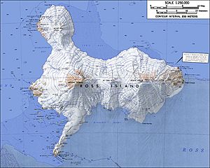
Mount Bird is a large volcano located in Antarctica, a very cold continent at the bottom of the world. It stands tall at 1,765 m (5,791 ft) (about 5,791 feet) on Ross Island. This island is famous for its volcanoes, including Mount Bird. Mount Bird is about 7 miles (11 km) south of Cape Bird, which is the northern tip of Ross Island.
What is Mount Bird?
Mount Bird is a type of volcano called a shield volcano. Imagine a warrior's shield lying on the ground – that's how these volcanoes look! They have gentle slopes because the lava that flows out is very runny. It spreads out far and wide before cooling down. Mount Bird is part of a group of volcanoes called the McMurdo Volcanic Group.
Exploring Mount Bird
Mount Bird was first mapped by explorers during the British National Antarctic Expedition, 1901–04. This important journey was led by Robert Falcon Scott. The explorers likely named the mountain after nearby Cape Bird, which they had already named. A large glacier called Endeavour Piedmont Glacier flows down the sides of Mount Bird.
Ice and Glaciers
Mount Bird has a big icecap on its top, and parts of this icecap stretch out like arms towards the west. One of these icy arms is called Quaternary Icefall. It's like a steep waterfall of ice that drops into Wohlschlag Bay. This bay is about 1 mile (1.6 km) south of a place called Cinder Hill.
Scientists from the New Zealand Geological Survey Antarctic Expedition (NZGSAE) mapped this area in 1958–59. They named the icefall "Quaternary" because they found very old seashells from the Quaternary glacial period inside the glacier. These shells were carried by the moving ice and left behind in piles of rock and dirt called terminal moraines when the glacier melted. Another icy arm of Mount Bird's icecap is called Shell Glacier.

Mount Bird is in the upper left.
Mount Erebus is in the lower left.
Mount Terra Nova is in the middle.
Mount Terror is in the right.
See also
 In Spanish: Monte Bird para niños
 | Misty Copeland |
 | Raven Wilkinson |
 | Debra Austin |
 | Aesha Ash |


