
Mount Dana (Washington) facts for kids
Quick facts for kids Mount Dana |
|
|---|---|
.jpg)
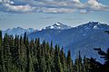
Mount Dana seen from Hurricane Ridge
|
|
| Highest point | |
| Elevation | 6,213 ft (1,894 m) NAVD 88 |
| Prominence | 1,529 ft (466 m) |
| Geography | |

Mount Dana
Location in Washington (state)

Mount Dana
Location in the United States
|
|
| Parent range | Olympic Mountains |
| Topo map | USGS McCartney Peak |
| Geology | |
| Age of rock | Eocene |
| Type of rock | Basalt |
| Climbing | |
| First ascent | 1928 by USGS Survey party |
| Easiest route | Scrambling |
Mount Dana is a tall mountain in Jefferson County, Washington state. It stands about 6,213 feet (1,894 m) high. This amazing peak is found inside Olympic National Park. It's part of the Olympic Mountains, specifically a smaller group called the Bailey Range.
The mountain was named after Charles Anderson Dana. He was a famous editor for a newspaper in New York called The Sun. Water from Mount Dana flows into the Elwha River. From there, it travels all the way to the Strait of Juan de Fuca.
Weather on Mount Dana
Mount Dana is in the northwestern part of the Olympic Mountains. This area has a "marine west coast" climate. This means the weather is often influenced by the nearby Pacific Ocean.
Most of the weather systems start over the Pacific Ocean. They then move northeast towards the Olympic Mountains. When these big air masses hit the tall mountains, they are forced to rise. As the air goes higher, it cools down. This causes it to drop its moisture as rain or snow. This process is called Orographic lift.
Because of this, the Olympic Mountains get a lot of rain and snow. This is especially true during the winter months. In winter, the sky is often cloudy. But in summer, high-pressure systems over the Pacific Ocean bring clear skies. This means lots of sunshine!
The snow here tends to be wet and heavy. This can make avalanches more likely. An avalanche is when a large amount of snow slides down a mountain.
Images for kids
-
Mount Dana centered in the distance
-
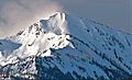
Mt. Dana


