
Mount Edith Cavell facts for kids
Quick facts for kids Mount Edith Cavell |
|
|---|---|

Mount Edith Cavell and the Angel Glacier
|
|
| Highest point | |
| Elevation | 3,363 m (11,033 ft) |
| Prominence | 2,007 m (6,585 ft) |
| Listing |
|
| Geography | |

Mount Edith Cavell
Location in Alberta

Mount Edith Cavell
Location in Canada
|
|
| Parent range | South Jasper Ranges |
| Topo map | NTS 83D/09 |
| Climbing | |
| First ascent | 1915 by A.J. Gilmour and E.W.D. Holway |
| Easiest route | Rock/ice climb, UIAA II |
Mount Edith Cavell is a tall mountain located in Jasper National Park in Alberta, Canada. It stands proudly in the Athabasca River and Astoria River valleys. It is the most important peak that is completely within Alberta.
The mountain was named in 1916 after Edith Cavell, a brave British nurse. During World War I, she helped soldiers escape from Belgium, which was occupied at the time. She was later arrested and faced serious consequences for her actions. Before this, the mountain was known as Mount Fitzhugh.
Contents
Exploring Mount Edith Cavell
You can get a great view of the mountain's north side by taking a short walk to Cavell Meadows. The path starts near the parking lot at the end of Mount Edith Cavell Road.
Hiking to Cavell Meadows
The trail to Cavell Meadows is about 3.8 kilometers (2.4 miles) long, one way. As you hike, you will climb about 370 meters (1,210 feet) to reach a height of 2,135 meters (7,000 feet). This trail is described in detail in The Canadian Rockies Trail Guide.
Seeing the Angel Glacier
From Cavell Meadows, you can see the amazing Angel Glacier. This glacier hangs over a 300-meter (980-foot) cliff on the mountain's north face. It looks like an angel's wings, which is how it got its name.
Visiting Cavell Lake
You can also find trails to the Tonquin Valley about one kilometer (0.6 miles) before the end of Mount Edith Cavell Road. There is a parking area across from the Mount Edith Cavell Hostel. A short walk leads to the north end of Cavell Lake. A small bridge crosses the stream that flows out of the lake. From here, you get beautiful views with the lake in front and the huge Mount Edith Cavell behind it.
The Big Rock Connection
It is believed that the world's largest glacial erratic is connected to Mount Edith Cavell. A glacial erratic is a large rock that was moved by a glacier. This huge rock, called Big Rock, is found near Okotoks, Alberta. About ten thousand years ago, a large piece of quartzite stone broke off Mount Edith Cavell. It was carried by the receding Athabasca River Valley glacier to where it sits today.
Climbing Adventures
Mount Edith Cavell offers several popular routes for mountain climbers. These routes are rated by their difficulty.
Popular Climbing Routes
- West Ridge (normal route): This is rated as Yosemite Decimal System II.
- East Ridge: This route is rated Yosemite Decimal System III, 5.3.
- North Face, East Summit: This is a more challenging climb, rated Yosemite Decimal System IV, 5.8.
The North Face route is considered a classic climb. It is even included in Steck and Roper's famous book, Fifty Classic Climbs of North America.
Notable Climbs
Some very skilled climbers have made important ascents on Mount Edith Cavell:
- 1961: The North Face route (IV 5.7) was first climbed by Yvon Chouinard, Fred Beckey, and Dan Doody. This happened on July 20–21.
- 1966: The North Face had its second ascent by Denny Eberl and Gray Thompson on July 30.
- 1967: Royal Robbins completed the first solo climb of the North Face.
Mount Edith Cavell in History
Mount Edith Cavell has even been featured on a Canadian stamp!
Stamp Feature
A $1 Canadian stamp was issued on December 4, 1930, showing Mount Edith Cavell.
Mountain Climate
The climate around Mount Edith Cavell is known as a subarctic climate. This means it has cold, snowy winters and mild summers.
Weather Conditions
Temperatures can drop below -20 °C ( -4 °F) in winter. With the wind, it can feel even colder, sometimes below -30 °C (-22 °F). The water from melting snow and ice on the mountain flows into streams that lead to the Athabasca River.
Images for kids
-
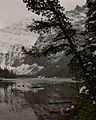
Snow is often evident and the lake begins to freeze over by early October.
-
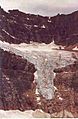
Angel Glacier in 1992


