Okotoks facts for kids
Quick facts for kids
Okotoks
|
||
|---|---|---|
|
Town
|
||
| Town of Okotoks | ||
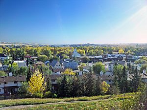
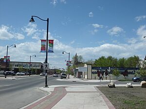
A view of Okotoks; overlooking downtown and facing south.
|
||
|
||
| Motto(s):
Historic Past, Sustainable Future
|
||
| Country | Canada | |
| Province | Alberta | |
| Region | Calgary Region | |
| Census division | 6 | |
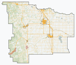
| Municipal district | Foothills County | |
| Incorporated | ||
| • Village | 25 October 1899 | |
| • Town | 1 June 1904 | |
| Area
(2021)
|
||
| • Land | 38.55 km2 (14.88 sq mi) | |
| Elevation | 1,051 m (3,448 ft) | |
| Population
(2021)
|
||
| • Total | 30,405 | |
| • Density | 788.7/km2 (2,043/sq mi) | |
| • Municipal census (2015) | 28,016 | |
| • Estimate (2020) | 31,708 | |
| Time zone | UTC−07:00 (MST) | |
| • Summer (DST) | UTC−06:00 (MDT) | |
| Forward sortation area |
T1S
|
|
| Area code(s) | 403, 587, 825, 368 | |
| Waterway | Sheep River | |
Okotoks is a town in Alberta, Canada. It's part of the Calgary Region. The town is located on the Sheep River, about 38 kilometers (24 miles) south of Downtown Calgary. Okotoks has become a "bedroom community" for Calgary, meaning many people who live there travel to Calgary for work. In 2021, the town had a population of 30,214, making it the largest town in Alberta.
Contents
Okotoks: A Town with a Rich Past
The Meaning Behind the Name
The name "Okotoks" comes from the Blackfoot language word "ohkotok", which means "rock". This name likely refers to Big Rock, a very large rock left behind by a glacier. This huge rock is about 7 kilometers (4.3 miles) west of the town.
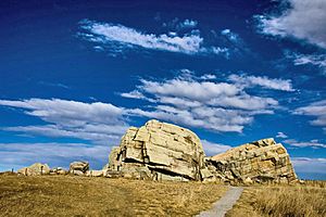
Before European settlers arrived, First Nations people, especially the Blackfoot Confederacy, used Big Rock as a landmark. It helped them find a good place to cross the river near where Okotoks is now. These tribes often moved around, following large herds of buffalo for food.
Early Settlement and the Macleod Trail
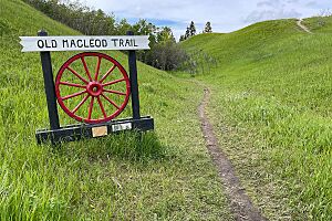
In the late 1870s and early 1880s, the area where Okotoks stands was a key river crossing. It was on a busy route for wagons carrying goods from Fort Macleod to Fort Calgary. Stagecoaches also used this path, known as the Macleod Trail.
Two stopping houses were built on the north side of the river. These places offered rest and shelter for travelers. Because of these stopping houses, people started to settle in the area. When the railway was built through the town in 1892, the old trail was used less often.
In 1879, the last buffalo in the area were killed. In 1880, the government started leasing land, which brought big changes to the region. The first settlers arrived in 1882.
Growth and Name Changes
A community began to grow around a sawmill that opened in 1891. This mill helped the town get bigger. The last stagecoach came through Okotoks in 1891, as trains took over travel between Calgary and Fort Macleod.
By 1897, the community's name had changed three times! It was first called Sheep Creek, then Dewdney. But because there was already a place called Dewdney in British Columbia, local businessman John Lineham chose the name Okotoks. The railway line is still used today for trains going south to the United States.
In 2007, a special community called the Drake Landing Solar Community was built in Okotoks. It's known for being very energy efficient.
Dealing with Floods
Okotoks has faced three big floods: in 1995, 2005, and 2013. The 2005 flood, which hit much of southern Alberta, covered almost all the land next to the Sheep River. Even the main business area was flooded for a short time. The worst damage was to riverside paths, parks, and campgrounds. Okotoks was also affected by the 2013 Alberta floods.
Protecting Old Buildings
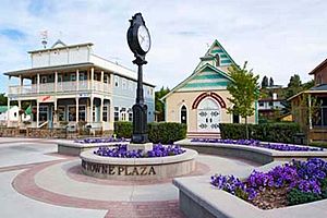
Many old buildings in Okotoks have been fixed up and saved. One house was even moved blocks away to keep it from being torn down when the highway was made wider.
Okotoks: Its Land and Environment
Growing the Town's Land
On July 1, 2017, the government approved Okotoks adding about 1,950 hectares (4,800 acres) of land to its size. Okotoks and the Municipal District of Foothills agreed on this after the town wanted more land for its future growth. This new land will help the town build homes and other services for the next several decades.
Saving Water in Okotoks
Even though the Sheep River flows through Okotoks all year, the town gets its water from underground wells near the river. In 1998, Okotoks was one of the first places in Canada to realize that its growth was limited by how much water was available in the local area. Because of concerns about water supply, the town made a unique and somewhat debated suggestion: to limit its population to 25,000 residents.
Okotoks Weather and Climate
Okotoks has a humid continental climate. This means it has generally warm summers and long, cold winters. Most of the rain falls in the summer, usually between May and September.
| Climate data for Okotoks (1981−2010) | |||||||||||||
|---|---|---|---|---|---|---|---|---|---|---|---|---|---|
| Month | Jan | Feb | Mar | Apr | May | Jun | Jul | Aug | Sep | Oct | Nov | Dec | Year |
| Record high °C (°F) | 14.5 (58.1) |
23.0 (73.4) |
25.0 (77.0) |
25.5 (77.9) |
31.5 (88.7) |
32.5 (90.5) |
34.5 (94.1) |
34.0 (93.2) |
33.5 (92.3) |
27.5 (81.5) |
23.0 (73.4) |
18.0 (64.4) |
34.5 (94.1) |
| Mean daily maximum °C (°F) | −2.3 (27.9) |
1.0 (33.8) |
4.9 (40.8) |
11.7 (53.1) |
16.8 (62.2) |
20.2 (68.4) |
24.3 (75.7) |
23.7 (74.7) |
18.9 (66.0) |
11.5 (52.7) |
3.4 (38.1) |
−0.5 (31.1) |
11.1 (52.0) |
| Daily mean °C (°F) | −8.1 (17.4) |
−5.0 (23.0) |
−1.4 (29.5) |
5.0 (41.0) |
9.8 (49.6) |
13.7 (56.7) |
17.0 (62.6) |
16.2 (61.2) |
11.5 (52.7) |
5.0 (41.0) |
−2.3 (27.9) |
−6.3 (20.7) |
4.6 (40.3) |
| Mean daily minimum °C (°F) | −13.8 (7.2) |
−10.9 (12.4) |
−7.7 (18.1) |
−1.7 (28.9) |
2.8 (37.0) |
7.1 (44.8) |
9.6 (49.3) |
8.6 (47.5) |
4.1 (39.4) |
−1.6 (29.1) |
−8.0 (17.6) |
−12.0 (10.4) |
−2.0 (28.4) |
| Record low °C (°F) | −39.0 (−38.2) |
−36.0 (−32.8) |
−32.0 (−25.6) |
−20.5 (−4.9) |
−8.0 (17.6) |
−1.5 (29.3) |
2.0 (35.6) |
−3.0 (26.6) |
−9.0 (15.8) |
−26.0 (−14.8) |
−32.5 (−26.5) |
−39.0 (−38.2) |
−39.0 (−38.2) |
| Average precipitation mm (inches) | 14.8 (0.58) |
17.3 (0.68) |
28.6 (1.13) |
37.9 (1.49) |
70.4 (2.77) |
123.6 (4.87) |
54.4 (2.14) |
61.7 (2.43) |
45.8 (1.80) |
25.3 (1.00) |
21.9 (0.86) |
12.9 (0.51) |
514.5 (20.26) |
| Average rainfall mm (inches) | 0.3 (0.01) |
0.1 (0.00) |
1.6 (0.06) |
16.0 (0.63) |
59.1 (2.33) |
123.6 (4.87) |
54.4 (2.14) |
61.3 (2.41) |
43.4 (1.71) |
10.1 (0.40) |
2.3 (0.09) |
0.4 (0.02) |
372.6 (14.67) |
| Average snowfall cm (inches) | 14.5 (5.7) |
17.2 (6.8) |
26.9 (10.6) |
21.9 (8.6) |
11.3 (4.4) |
0.0 (0.0) |
0.0 (0.0) |
0.4 (0.2) |
2.5 (1.0) |
15.2 (6.0) |
19.6 (7.7) |
12.4 (4.9) |
141.9 (55.9) |
| Average precipitation days (≥ 0.2 mm) | 6.7 | 6.5 | 9.2 | 9.8 | 12.9 | 14.5 | 10.9 | 10.9 | 9.0 | 7.8 | 6.7 | 5.8 | 110.7 |
| Average rainy days (≥ 0.2 mm) | 0.2 | 0.3 | 1.3 | 5.7 | 11.8 | 14.5 | 10.9 | 10.9 | 8.6 | 4.4 | 1.3 | 0.5 | 70.4 |
| Average snowy days (≥ 0.2 cm) | 6.5 | 6.5 | 8.7 | 6.1 | 2.8 | 0.0 | 0.0 | 0.2 | 1.0 | 4.4 | 5.9 | 5.5 | 47.6 |
| Source: Environment Canada | |||||||||||||
Okotoks Neighbourhoods
Okotoks has many different neighbourhoods, including:
- Air Ranch
- Central Heights
- Cimarron
- Cornerstone
- Crystal Shores
- Crystal Ridge
- D'Arcy
- Downey Ridge
- Drake Landing Solar Community
- Green Haven Estates
- Hunter's Glen
- Mountainview
- Olde Towne
- Rosemont
- Ranchers Rise
- Sandstone
- Sheep River Ridge
- Skunk Hollow
- Suntree
- Tower Hill
- Wedderburn
- Westmount
- Westridge
- Woodhaven
Okotoks Population and People
| Federal census population history |
||
|---|---|---|
| Year | Pop. | ±% |
| 1901 | 245 | — |
| 1906 | 508 | +107.3% |
| 1911 | 516 | +1.6% |
| 1916 | 525 | +1.7% |
| 1921 | 448 | −14.7% |
| 1926 | 579 | +29.2% |
| 1931 | 760 | +31.3% |
| 1936 | 571 | −24.9% |
| 1941 | 591 | +3.5% |
| 1946 | 694 | +17.4% |
| 1951 | 767 | +10.5% |
| 1956 | 764 | −0.4% |
| 1961 | 1,043 | +36.5% |
| 1966 | 922 | −11.6% |
| 1971 | 1,247 | +35.2% |
| 1976 | 1,795 | +43.9% |
| 1981 | 3,847 | +114.3% |
| 1986 | 5,214 | +35.5% |
| 1991 | 6,720 | +28.9% |
| 1996 | 8,510 | +26.6% |
| 2001 | 11,664 | +37.1% |
| 2006 | 17,145 | +47.0% |
| 2011 | 24,511 | +43.0% |
| 2016 | 28,881 | +17.8% |
| 2021 | 30,405 | +5.3% |
| Source: Statistics Canada |
||
In the 2021 Canadian census, Okotoks had a population of 30,405 people. This was an increase from its 2016 population of 29,016. With a land area of 38.55 square kilometers (14.88 sq mi), the town had about 788.7 people per square kilometer in 2021.
Okotoks is the largest town in Alberta. A town can become a city when its population reaches 10,000 residents.
Diverse Backgrounds in Okotoks
Okotoks is home to people from many different backgrounds. Here's a look at the main groups:
| Panethnic group | 2021 | 2016 | 2011 | 2006 | 2001 | |||||
|---|---|---|---|---|---|---|---|---|---|---|
| Pop. | % | Pop. | % | Pop. | % | Pop. | % | Pop. | % | |
| European | 26,130 | 87.04% | 25,330 | 88.81% | 22,490 | 92.08% | 16,030 | 93.52% | 11,135 | 95.7% |
| Indigenous | 1,605 | 5.35% | 1,135 | 3.98% | 1,065 | 4.36% | 460 | 2.68% | 270 | 2.32% |
| Southeast Asian | 990 | 3.3% | 840 | 2.95% | 240 | 0.98% | 110 | 0.64% | 40 | 0.34% |
| South Asian | 335 | 1.12% | 335 | 1.17% | 215 | 0.88% | 145 | 0.85% | 25 | 0.21% |
| African | 260 | 0.87% | 240 | 0.84% | 165 | 0.68% | 85 | 0.5% | 80 | 0.69% |
| East Asian | 250 | 0.83% | 370 | 1.3% | 170 | 0.7% | 210 | 1.23% | 80 | 0.69% |
| Latin American | 250 | 0.83% | 145 | 0.51% | 65 | 0.27% | 55 | 0.32% | 0 | 0% |
| Middle Eastern | 65 | 0.22% | 0 | 0% | 0 | 0% | 0 | 0% | 10 | 0.09% |
| Other/multiracial | 150 | 0.5% | 140 | 0.49% | 20 | 0.08% | 35 | 0.2% | 0 | 0% |
| Total responses | 30,020 | 98.73% | 28,520 | 98.29% | 24,425 | 99.65% | 17,140 | 99.97% | 11,635 | 99.54% |
| Total population | 30,405 | 100% | 29,016 | 100% | 24,511 | 100% | 17,145 | 100% | 11,689 | 100% |
| Note: Totals greater than 100% due to multiple origin responses | ||||||||||
Languages Spoken in Okotoks
In 2006, about 93% of Okotoks residents said English was their first language. A smaller number spoke French (1.4%) or German (1.0%) as their first language. Other common languages included Spanish, Tagalog, Chinese, Korean, and Slovak.
Okotoks: Its Economy and Jobs
The sawmill started by John Lineham in 1891 was a big part of Okotoks' early economy. It ran for 25 years and employed many people, producing a lot of lumber every day. This lumber was used to build railway ties for the growing Canadian Pacific Railway. Logs were floated down the Sheep River to the mill. The mill is gone now, but one of its old buildings still stands. It used to be a dairy and now holds a law office and restaurant.
In 1900, four brick-making factories opened just west of Okotoks. Many of the first brick buildings in town were made with these local bricks. The brick industry was busiest in 1912, making twelve million bricks. But World War I caused the factories to close.
Oil was discovered west of Okotoks on October 7, 1913. This made Okotoks a busy supply center. From 1913 to the 1960s, the town was full of horses, wagons, and trucks moving equipment to the oil fields and bringing crude oil back to Calgary.
The Texas Gulf sulphur plant opened in 1959. It employed 45 people and produced large piles of bright yellow sulphur.
Since 1974, Okotoks has hosted a collector car auction every May. It's the longest-running collector car auction in Canada!
Okotoks used to be one of the few towns its size with its own airport. Small air shows were held there. It was also home to an aircraft charter company and flight schools. Now, this area has become the Calgary/Okotoks Air Park. Here, people can build homes with attached hangars for their private planes. There's also a small private airfield called Calgary/Okotoks (Rowland Field) Aerodrome. For bigger flights, Okotoks uses the Calgary International Airport.
Getting Around Okotoks
Okotoks Transit offers a bus service that you can request when you need it. This system started in 2019 and uses accessible vans instead of regular buses.
Okotoks in the News
Print Media
- Western Wheel, a local weekly newspaper, is published by Great West Newspapers.
Radio Stations
- 100.9 FM — CKUV-FM (The Eagle 100.9), owned by Golden West Broadcasting.
See also
 In Spanish: Okotoks para niños
 | William M. Jackson |
 | Juan E. Gilbert |
 | Neil deGrasse Tyson |


