
Mount Gipps, Queensland facts for kids
Quick facts for kids Mount GippsQueensland |
|||||||||||||||
|---|---|---|---|---|---|---|---|---|---|---|---|---|---|---|---|
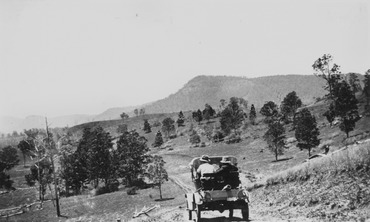
Mount Gipps on McPherson Range, 1928
|
|||||||||||||||

Mount Gipps
Location in Queensland
|
|||||||||||||||
| Population | 0 (2021 census) | ||||||||||||||
| • Density | 0/km2 (0/sq mi) | ||||||||||||||
| Postcode(s) | 4285 | ||||||||||||||
| Area | 15.7 km2 (6.1 sq mi) | ||||||||||||||
| Time zone | AEST (UTC+10:00) | ||||||||||||||
| Location |
|
||||||||||||||
| LGA(s) | Scenic Rim Region | ||||||||||||||
| State electorate(s) | Scenic Rim | ||||||||||||||
| Federal Division(s) | Wright | ||||||||||||||
|
|||||||||||||||
Mount Gipps is a quiet, rural area in Queensland, Australia. It's part of the Scenic Rim Region. In 2021, very few people lived there, or perhaps none at all.
Mount Gipps is right next to the state of New South Wales. It is also one end of the famous Queensland rabbit-proof fence.
Contents
Exploring the Landscape of Mount Gipps
Mount Gipps has tall slopes in the south. These slopes are part of the McPherson Range. There are also high areas in the north-east. A valley runs through the area from west to east.
The mountain called Mount Gipps gives the area its name. This mountain is on the southern border with New South Wales. It rises to 785 meters (about 2,575 feet) above sea level.
Running Creek flows through Mount Gipps from east to west. This creek is a branch of the Logan River. Mount Gipps Road comes into the area from Chinghee Creek in the north-west. It follows the path of the valley.
Most of the land is privately owned. However, only the lower valley areas have been cleared. These parts are used for grazing animals. The higher slopes are covered with many trees.
A Look Back at Mount Gipps' History

Around the year 1900, a lot of the land near Running Creek was part of a large farm. This farm was called Telemon Crossing. It was owned by a person named A. Drynan.
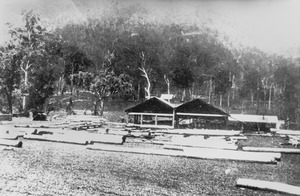
There was a sawmill in Mount Gipps for many years. It started operating around 1920. This sawmill was located in the valley area.
A school called Mount Gipps State School opened on July 21, 1920. It helped educate children in the area. The school closed its doors on June 30, 1954. The old school building was located at 220 Mount Gipps Road.
Who Lives in Mount Gipps?
In 2016, there were 7 people living in Mount Gipps. There were 8 households in the area. About 30% of the people were males, and 70% were females. The average age of people living there was 52 years old. This was older than the national average.
The average weekly income for households was $0. This was much lower than the national average. By 2021, the population had become very small, or even zero.
Learning Opportunities Near Mount Gipps
There are no schools located directly in Mount Gipps. The closest government primary school is Hillview State School. It is located in Hillview, to the north of Mount Gipps.
For older students, the nearest government high school is Beaudesert State High School. This school is located in Beaudesert, which is further north.
