Mount Gray (Vermilion Range) facts for kids
Quick facts for kids Mount Gray |
|
|---|---|

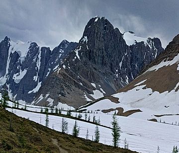
Mount Gray seen from Rockwall Pass
|
|
| Highest point | |
| Elevation | 2,886 m (9,469 ft) |
| Prominence | 136 m (446 ft) |
| Parent peak | Tumbling Peak (3145 m) |
| Listing | Mountains of British Columbia |
| Geography | |
| Location | Kootenay National Park British Columbia, Canada |
| Parent range | Vermilion Range Canadian Rockies |
| Topo map | NTS 82N01 |
| Geology | |
| Age of rock | Cambrian |
| Type of rock | Ottertail Limestone |
Mount Gray is a tall mountain peak in British Columbia, Canada. It stands about 2,886 meters (9,469 feet) high. This mountain is located on the western edge of Kootenay National Park. It is part of the Vermilion Range, which is a smaller part of the huge Canadian Rockies.
Mount Gray is also part of a famous feature called "The Rockwall." This is a very steep cliff line that stretches for many kilometers. The Rockwall Trail is a popular hiking path, about 55 kilometers (34 miles) long. Hikers on this trail can see amazing alpine passes, green meadows, hanging glaciers, and towering limestone cliffs. Some of these cliffs rise more than 900 meters (2,953 feet) above the trail!
What is Mount Gray Made Of?
Mount Gray is mostly made of a type of rock called Ottertail limestone. Limestone is a sedimentary rock, which means it formed from layers of tiny bits of rock, shells, and sand that settled at the bottom of ancient seas. The rocks of Mount Gray were formed during the Cambrian period, which was a very long time ago.
Later, during a time called the Laramide orogeny, huge forces pushed these rock layers. This movement caused the rocks to fold and lift, creating the mountains we see today.
How Mount Gray Got Its Name
In 1918, a scientist named Charles Doolittle Walcott suggested naming the mountain "Mount Cambria." This was because the mountain was made completely of rocks from the Cambrian period.
However, in 1924, the Geographical Names Board of Canada officially named it Mount Gray. This name honors William J. Gray. He was a student at the University of British Columbia and helped start the British Columbia Mountaineering Club. William J. Gray was doing important geological survey work near the Kootenay River in 1917. Sadly, he passed away during this work. Mount Drysdale, another peak nearby, was named after Charles Wales Drysdale, who was with William J. Gray during the survey. These two mountains stand on opposite sides of Wolverine Pass.
Weather Around Mount Gray
Mount Gray is located in a subarctic climate zone. This means the area has very cold and snowy winters. Summers are usually mild. Temperatures can drop below −20 °C (–4 °F), and with the wind, it can feel even colder, sometimes below −30 °C (–22 °F).
When snow melts or rain falls on the mountain, the water flows in two main directions. Some water drains east into smaller streams that feed the Vermilion River. Other water flows west into streams that join the Beaverfoot River.
 | Charles R. Drew |
 | Benjamin Banneker |
 | Jane C. Wright |
 | Roger Arliner Young |


