
Mount Matier facts for kids
Quick facts for kids Mount Matier |
|
|---|---|

Mount Matier
|
|
| Highest point | |
| Elevation | 2,783 m (9,131 ft) |
| Prominence | 1,241 m (4,072 ft) |
| Parent peak | Skihist Mountain (2968 m) |
| Geography | |

Mount Matier
Location in British Columbia

Mount Matier
Location in Canada
|
|
| Location | Joffre Lakes Provincial Park British Columbia, Canada |
| Parent range | Joffre Group Coast Ranges |
| Topo map | NTS 92J/8 |
| Climbing | |
| First ascent | 1957 |
| Easiest route | Scrambling, glacier travel |
Mount Matier is a very tall mountain in British Columbia, Canada. It stands 2,783 meters (about 9,131 feet) high. You can find it in Joffre Lakes Provincial Park. This mountain is the highest point in a group of mountains called the Joffre Group. This group is part of the larger Coast Mountains range.
Mount Matier is about 26 kilometers (16 miles) east of Pemberton. It is also about 9 kilometers (6 miles) northeast of Lillooet Lake. The closest higher mountain is Mount Weart, which is about 30 kilometers (19 miles) to the southwest.
The sides of Mount Matier are covered by several large ice fields called glaciers. These include the Matier Glacier, Anniversary Glacier, Twin One Glacier, and Hartzell Glacier. Water from the melting snow and ice flows into Joffre Creek and Twin One Creek. These creeks then flow into the Lillooet River.
The first time people successfully climbed to the top of Mount Matier was on August 18, 1957. The climbers were Dick Chambers, Joe Hutton, Roy Mason, Paddy Sherman, and Cyril Scott. They were all members of the British Columbia Mountaineering Club. The mountain was named after Tom Matier. He was a well-known prospector, someone who explored for valuable minerals, in the area a long time ago. The name was officially accepted on April 21, 1966. This was done by the Geographical Names Board of Canada.
Mountain Weather

Mount Matier is in a subarctic climate zone. This means it has long, cold winters and short, cool summers. Most of the weather in this area comes from the Pacific Ocean. These weather systems, called weather fronts, move east towards the Coast Mountains.
When the air hits the mountains, it is forced to rise. This process is called Orographic lift. As the air rises, it cools down and drops its moisture. This causes a lot of rain or snow to fall on the Coast Mountains. Because of this, the area gets a lot of precipitation, especially heavy snowfall in winter.
Temperatures on the mountain can drop very low, sometimes below −20 °C (minus 4 °F). With the wind, it can feel even colder, below −30 °C (minus 22 °F). The best time to climb Mount Matier is usually from July through September. The weather is more stable and warmer during these months.
.jpg)
Climbing Paths
Here are some known ways to climb Mount Matier:
- North Ridge - This route involves rock climbing with a difficulty rating of class 3. You reach it by crossing the Anniversary Glacier.
- West Face - This route also involves rock climbing, with a difficulty rating of class 3-4. You reach it by crossing the Matier Glacier.
Images for kids
-
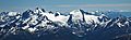
The Joffre Group: Joffre Peak (left), Mt. Matier (highest), Hartzell, Spetch, Slalok Mountain, Tszil, and Taylor (farthest right)
