
Mount Pugh facts for kids
Quick facts for kids Mount Pugh |
|
|---|---|
 |
|
| Highest point | |
| Elevation | 7,201 ft (2,195 m) |
| Prominence | 2,801 ft (854 m) |
| Geography | |

Mount Pugh
Location in Washington (state)

Mount Pugh
Location in the United States
|
|
| Location | Snohomish County, Washington, U.S. |
| Parent range | Cascade Range |
| Topo map | USGS Pugh Mountain |
| Climbing | |
| First ascent | 1916 by Nels Bruseth |
| Easiest route | Scramble, class 2-3 |
Mount Pugh, sometimes called Pugh Mountain or by its native name Da Klagwats, is a tall peak in the North Cascades mountains of Washington state. It is located about 12 miles (19.6 km) west of Glacier Peak, which is a type of volcano called a stratovolcano. Mount Pugh rises dramatically from the valleys below. For example, it climbs over 6,150 feet (1,875 meters) from the Sauk River Valley in just two miles (3.2 km) horizontally. The mountain was named after John Pugh, who settled nearby in 1891.
Contents
Climbing Mount Pugh
The first recorded climb of Mount Pugh was in 1916 by Nels Bruseth. However, it's possible that other people, including Native Americans, climbed it much earlier. This is because the easiest way to the top doesn't require special climbing gear or advanced skills.
The trail to the summit is mostly easy to follow. But the last 1.5 miles (2.4 km) are along a very narrow ridge, like a "razorback." This part has significant exposure, meaning there are steep drops on both sides, so you need to be very careful. This trail, called the Northwest Ridge (Trail Number 644), starts in the Sauk River Valley. To reach the top, climbers gain almost exactly one mile (5,280 feet or 1,609 meters) in elevation.
Weather and Climate at Mount Pugh
Mount Pugh is in a marine west coast climate zone, which means it's near the ocean and gets a lot of moisture. Most weather systems start over the Pacific Ocean and move northeast toward the Cascade Mountains.
When these weather systems reach the North Cascades, the mountains force the air to rise. This process is called orographic lift. As the air rises, it cools and drops its moisture as rain or snow onto the Cascades. Because of this, the western side of the North Cascades gets a lot of precipitation, especially heavy snowfall in winter.
Thanks to the ocean's influence, temperatures rarely go below 0°F (-18°C) or above 80°F (27°C) in this area. Winters are usually cloudy. However, during summer, high-pressure systems over the Pacific Ocean often bring clear, sunny skies. The snow here tends to be wet and heavy, which can increase the risk of avalanches.
How Mount Pugh Was Formed
The North Cascades mountains have very rugged shapes with sharp peaks, long ridges, and deep valleys carved by glaciers. These dramatic landscapes and big changes in elevation were created by geological events that happened millions of years ago.
Ancient Earth Movements
The formation of the Cascade Mountains began millions of years ago, during the late Eocene Epoch. At that time, the North American Plate (a huge piece of Earth's crust) was slowly moving over the Pacific Plate. This movement caused many periods of volcanic activity, where molten rock (magma) pushed up from inside the Earth.
Also, smaller pieces of Earth's crust, called terranes, collided and joined together to form the North Cascades about 50 million years ago.
Ice and Valleys
During the Pleistocene period, which started over two million years ago, huge sheets of ice (glaciers) repeatedly moved across the land. As they advanced and retreated, they scraped and shaped the landscape, leaving behind piles of rock debris. The U-shaped valleys you see today were carved out by these glaciers.
The combination of the land being pushed up (called uplift) and cracks forming in the Earth's crust (called faulting), along with the action of glaciers, are the main reasons why the North Cascades has such tall peaks and deep valleys.
Images for kids
-
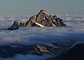
Pugh from Painted Mountain
-
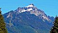
Pugh from Mountain Loop road
-
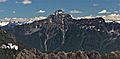
Pugh from Mount Dickerman
-

Approaching the summit of Pugh


