
Mount Worthington (Washington) facts for kids
Quick facts for kids Mount Worthington |
|
|---|---|

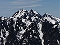
North aspect. Northeast peak left, summit to right
|
|
| Highest point | |
| Elevation | 6,938 ft (2,115 m) |
| Prominence | 498 ft (152 m) |
| Isolation | 1.04 mi (1.67 km) |
| Parent peak | Buckhorn Mountain (6,988 ft) |
| Geography | |

Mount Worthington
Location in Washington (state)

Mount Worthington
Location in the United States
|
|
| Location | Buckhorn Wilderness Jefferson County, Washington, US |
| Parent range | Olympic Mountains |
| Topo map | USGS Mount Townsend |
| Geology | |
| Age of rock | Eocene |
| Climbing | |
| Easiest route | class 3 scramble |
Mount Worthington is a tall mountain in the eastern Olympic Mountains in Washington state. It stands about 6,938-foot (2,115-metre) high. This mountain has two main peaks, making it a "double-summit" mountain.
You can find Mount Worthington in Jefferson County. It is part of the Buckhorn Wilderness, which is managed by the Olympic National Forest. The mountain's closest higher neighbor is Buckhorn Mountain, located about 1.3 mi (2.1 km) to the southwest.
Water from Mount Worthington flows in two directions. Rain and melting snow either go south into the Big Quilcene River or north into Copper Creek. Copper Creek then joins the Dungeness River.
This mountain was first called Copper Peak. Later, it was renamed by Jack Christensen. He named it after the William J. Worthington family. They were early settlers, or pioneers, in the nearby town of Quilcene.
In the early 1900s, copper was mined at the Tubal Cain mine. This mine was located at the northern base of Mount Worthington. Near the old mine, you can still find parts of a B-17 plane. This plane crashed on January 19, 1952, while returning from a search-and-rescue mission.
Understanding Mount Worthington's Climate

Mount Worthington is in a special climate zone called the marine west coast. This means it gets a lot of influence from the ocean. Most of the weather systems that affect the mountain come from the Pacific Ocean. They usually travel northeast towards the Olympic Mountains.
As these weather systems hit the tall Olympic peaks, they are forced to rise. This process is called Orographic lift. When the air rises, it cools down, and the moisture in it turns into rain or snow. This is why the Olympic Mountains get a lot of precipitation, especially heavy snowfall in winter.
During the winter, the weather is often cloudy. However, in the summer, high-pressure systems over the Pacific Ocean become stronger. This often leads to clear skies and sunny weather. Because of the ocean's influence, the snow on Mount Worthington tends to be wet and heavy. This type of snow can increase the risk of avalanches.
The Geology of Olympic Mountains
The Olympic Mountains, including Mount Worthington, are made of interesting rock types. These rocks were formed from broken pieces of other rocks and parts of the ocean floor. They are mostly Eocene-era sandstone, turbidite (rocks formed from underwater landslides), and basalt (a type of volcanic rock).
The mountains you see today were shaped over a long time. During the Pleistocene era, huge sheets of ice called glaciers moved across the land. These glaciers carved out valleys and peaks as they advanced and retreated many times. This process of erosion by glaciers gave the Olympic Mountains their unique look.
Images for kids
-
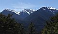
Mt. Worthington (centered), Buckhorn Mountain (right) seen from Mt. Townsend.
-
Mt. Worthington centered, north aspect
-
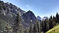
Mt. Worthington (left), Buckhorn Mountain (right) seen from Tubal Cain Trail


