Mountain Iron, Minnesota facts for kids
Quick facts for kids
Mountain Iron
|
|
|---|---|

This city is founded on the taconite iron ore deposits discovered by Leonidas Merritt in the 1880s.
|
|
| Motto(s):
Taconite Capital of the World
|
|

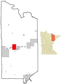
Location of the city of Mountain Iron
within Saint Louis County, Minnesota |
|
| Country | United States |
| State | Minnesota |
| County | Saint Louis |
| Founded | 1892 |
| Incorporated (village) | November 28, 1892 |
| Incorporated (city) | June 20, 1913 |
| Area | |
| • Total | 70.89 sq mi (183.61 km2) |
| • Land | 68.11 sq mi (176.40 km2) |
| • Water | 2.79 sq mi (7.21 km2) |
| Elevation | 1,480 ft (451 m) |
| Population
(2020)
|
|
| • Total | 2,878 |
| • Estimate
(2022)
|
2,860 |
| • Density | 42.26/sq mi (16.32/km2) |
| Time zone | UTC−6 (Central (CST)) |
| • Summer (DST) | UTC−5 (CDT) |
| ZIP Codes |
55768 and 55792
|
| Area code(s) | 218 |
| FIPS code | 27-44548 |
| GNIS feature ID | 0661972 |
| Sales tax | 7.375% |
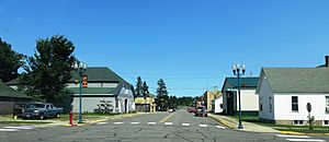
Mountain Iron is a city in Saint Louis County, Minnesota, in the United States. It is located in the middle of the Mesabi Range, an area famous for its iron ore. In 2020, about 2,878 people lived here.
U.S. Highway 169 is the main road that goes through Mountain Iron. The city's special saying, or motto, is "Taconite Capital of the World." This is because a large mine called Minntac, owned by the United States Steel Corporation, is located nearby.
Mountain Iron is one of the "Quad Cities." The other cities in this group are Virginia, Eveleth, and Gilbert.
Contents
History of Mountain Iron
Mountain Iron started in 1892 as a small village for miners. It was part of a bigger area called Nichols Township. The village got its name from the Mountain Iron Mine, which was very important nearby.
Later, in 1972, Mountain Iron officially became a city. This was a big step for the community.
Geography and Location
Mountain Iron covers a total area of about 71.31 square miles (183.61 square kilometers). Most of this area, about 68.52 square miles (176.40 square kilometers), is land. The rest, about 2.79 square miles (7.21 square kilometers), is water.
Population and People
| Historical population | |||
|---|---|---|---|
| Census | Pop. | %± | |
| 1900 | 470 | — | |
| 1910 | 1,343 | 185.7% | |
| 1920 | 1,546 | 15.1% | |
| 1930 | 1,349 | −12.7% | |
| 1940 | 1,492 | 10.6% | |
| 1950 | 1,377 | −7.7% | |
| 1960 | 1,808 | 31.3% | |
| 1970 | 1,698 | −6.1% | |
| 1980 | 4,134 | 143.5% | |
| 1990 | 3,362 | −18.7% | |
| 2000 | 2,999 | −10.8% | |
| 2010 | 2,869 | −4.3% | |
| 2020 | 2,878 | 0.3% | |
| 2022 (est.) | 2,860 | −0.3% | |
| U.S. Decennial Census 2020 Census |
|||
How Many People Live Here?
In 2010, there were 2,869 people living in Mountain Iron. These people lived in 1,336 homes. About 40.4% of these homes were not families, meaning people lived alone or with roommates.
The average age of people in the city was 45.4 years old. About 20.7% of the people were under 18 years old. Also, about 17.4% of the people were 65 years old or older. The number of males and females in the city was almost equal.
See also
 In Spanish: Mountain Iron (Minnesota) para niños
 | Chris Smalls |
 | Fred Hampton |
 | Ralph Abernathy |


