Mountain Loop Highway facts for kids
Quick facts for kids
Mountain Loop Highway |
|
|---|---|
| Forest Route 20, Mountain Loop Scenic Byway | |
|
A map of the Mountain Loop Highway with paved sections highlighted in red and the unpaved section highlighted in blue
|
|
| Route information | |
| Maintained by Snohomish County and USFS | |
| Length | 52.00 mi (83.69 km)
39 miles (paved) and 13 miles (unpaved)
|
| Existed | March 23, 1936 (Construction begins) December 1941 (Highway opened)–present |
| Major junctions | |
| West end | |
| East end | |
| Highway system | |
| State highways in Washington Interstate • US • State Former PSH • 1964 renumbering • Former SR |
|
The Mountain Loop Highway is a special road in the state of Washington, USA. It winds through the western part of the Cascade Range mountains in Snohomish County. Even though it's called a "loop," this highway is only a part of a bigger circle. You need to use other roads like State Routes 92, 9, and 530 to complete the full loop. This highway is also known as Forest Route 20.
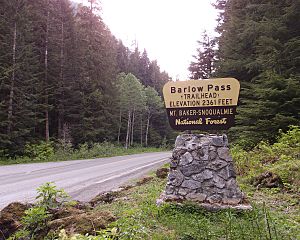
The highway connects two towns: Granite Falls and Darrington. About 34 miles (55 km) of the road from Granite Falls to Barlow Pass are paved. At Barlow Pass, the road becomes unpaved for about 13 miles (21 km). Then, it becomes paved again for the last 9 miles (14 km) to Darrington. The unpaved part is managed by the U.S. Forest Service. This section often closes for a long time because of flood damage.
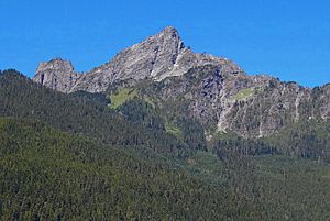
Along the highway, you can see Big Four Mountain and find the path to the Big Four Ice Caves. At Barlow Pass, there's a gravel road that leads to the old silver mining town of Monte Cristo. This road is closed to cars. The first part of the highway follows the Stillaguamish River. The second part follows the Sauk River. Inside the "loop" area, there are tall mountains like Three Fingers, Whitehorse Mountain, Mount Dickerman, and Mount Forgotten.
Contents
Exploring the Mountain Loop Highway
The First Paved Section
The Mountain Loop Highway begins in Granite Falls. Here, it's called N Alder Street. It heads north from Granite Falls and then turns east. This is where it meets the South Fork of the Stillaguamish River. The road generally follows this river.
Along this part, the highway passes through small communities like Robe, Verlot, and Silverton. It also connects with several other forest roads. The road continues until the river ends. It then reaches a private road that goes to the Old Monte Cristo Townsite. This old town is about 4 miles east of Barlow Pass.
The Unpaved Section
At Barlow Pass, the Mountain Loop Highway changes. It turns north and becomes an unpaved road called Forest Route 20 (FR 20). Soon after, FR 20 starts to follow the Sauk River as it heads towards Darrington.
FR 20 continues north past a place called Bedal. It becomes paved again near the new Whitechuck bridge, which is around mile marker 44.

The Second Paved Section
From Whitechuck, the Mountain Loop Highway stays paved and continues north. It still follows the Sauk River. On the other side of the river, another road, the N. Sauk River Road (Forest Route 22), runs next to the highway.
The highway then enters Darrington. Here, Railroad Avenue splits off. It acts as a short shortcut to the eastern end of the highway. The Mountain Loop Highway finally ends when it meets SR 530.
History of the Highway
The Mountain Loop Highway was officially started on March 23, 1936. Before this highway was built, there were very rough wagon roads. These roads connected the old mining town of Monte Cristo with Darrington and Granite Falls.
One of these old roads was called Wilmans Trail or Pioneer Trail. It was built in 1891 from Sauk City to Monte Cristo. In the same year, a surveyor named M.Q. Barlow found a way to reach Monte Cristo through the South Fork Stillaguamish River. Mining companies then paid to build a wagon road from Silverton to the Sauk wagon road, going through Barlow Pass. These old roads and some railroads generally followed the path of today's Mountain Loop Highway.
Construction of the modern highway began in 1936 and was finished in 1941. However, the road was closed in 1942 because of World War II.
The highway often closes in the winter because of floods. It usually reopens in the spring. But in 2003, a big windstorm closed the highway. More storms in 2006 and 2007 kept it closed until 2008.
The Mountain Loop Highway officially reopened on June 25, 2008. The towns along the full loop, including Arlington, Granite Falls, and Darrington, held a big celebration to mark the reopening.
Key Connections Along the Way
The Mountain Loop Highway connects to other important roads.
- In Granite Falls, the highway starts at SR 92. This is the western end of the Mountain Loop Highway.
- At Barlow Pass, the paved road ends, and the unpaved Forest Route 20 begins.
- Near Bedal, the highway connects to North Sauk River Road.
- In Darrington, there's a shortcut road called Railroad Avenue that leads to SR 530.
- The highway officially ends in Darrington at SR 530. From here, SR 530 continues north.
 | Ernest Everett Just |
 | Mary Jackson |
 | Emmett Chappelle |
 | Marie Maynard Daly |


