
Big Four Mountain facts for kids
Quick facts for kids Big Four Mountain |
|
|---|---|

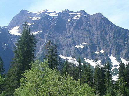
Big Four Mountain with South Fork Stillaguamish River
|
|
| Highest point | |
| Elevation | 6,160+ feet (1,880+ m) |
| Prominence | 1,080 ft (330 m) |
| Isolation | 2.1 mi (3.4 km) |
| Parent peak | Vesper Peak (6,214 ft) |
| Geography | |

Big Four Mountain
Location in Washington (state)

Big Four Mountain
Location in the United States
|
|
| Location | Snohomish County, Washington, U.S. |
| Parent range | Cascade Range |
| Topo map | USGS Silverton |
| Geology | |
| Age of rock | pre-Tertiary |
| Type of rock | Metasedimentary rock |
| Climbing | |
| First ascent | 1931 |
| Easiest route | class 3 scrambling East Face |
Big Four is a tall mountain in the Cascade Range in Washington state. It stands about 6,160 feet (1,877 meters) high. You can find it about 20 miles east of Granite Falls, Washington. The mountain is part of the Mount Baker-Snoqualmie National Forest.
One cool thing about Big Four Mountain is its unique snowfields. These are piles of snow and ice that stay all year round, even in summer! They are in the shadow of the mountain, which keeps them from melting.
During warmer months, water from melting snow flows under these snow piles. This creates amazing ice caves. These caves change size each year. They can also be very dangerous. The mountain is open to visitors. You can reach a large snowfield by a short trail. But the snowfield itself is off-limits. This is because of dangerous cave-ins and slides. Sadly, hikers have been hurt or killed here in the past.
What's in a Name?
Big Four Mountain has an interesting name. It is not named for the five peaks on its top. Some people think its name comes from a "figure four" shape. This shape can be seen in one of its snowfields. Another idea is that it was named after four brothers. These brothers were known to look for gold and trap animals in the valley.
The big pile of snow where the ice caves form was once called "Rucker's Glacier." But it's not a real glacier. It is known as the lowest place in the Cascades with permanent ice.
A resort called Big Four Inn was built near the mountain's base. The Rucker Brothers built it in 1921. It was a popular spot until a fire destroyed it in 1949.
The first people to climb Big Four Mountain reached the top on July 19, 1931. Their names were Forest Farr and Art Winder. They climbed up the northwest ridge.
Mountain Weather
Big Four Mountain is in a special weather zone. This is called the marine west coast climate. It means the weather is often wet and mild. Most weather systems come from the Pacific Ocean. They move northeast towards the Cascade Mountains.
When these weather systems hit the tall Cascade peaks, they are forced upwards. This makes them drop their moisture. So, the west side of the Cascades gets a lot of rain or snow. This happens especially in winter.
Winters are usually cloudy here. But in summer, high pressure over the Pacific Ocean often brings clear skies. This makes July through September the best time to visit or climb the mountain. The snow here tends to be wet and heavy. This can create a risk of avalanches.
How Mountains Form
The North Cascades area has very rugged land. You can see jagged peaks, long ridges, and deep valleys carved by ice. The way the land looks today was shaped by huge geological events. These events happened millions of years ago.
The Cascade Mountains started forming a very long time ago. This was during the late Eocene Epoch. This is when the North American Plate slowly moved over the Pacific Plate. This movement caused volcanoes to erupt. It also created new land. Small pieces of land, called terranes, joined together. This helped form the North Cascades about 50 million years ago.
Later, during the Pleistocene period (over two million years ago), huge sheets of ice called glaciers moved across the land. They moved back and forth many times. As they moved, they scraped away rock. This left behind piles of rock debris. The "U"-shaped valleys you see today were carved by these glaciers. The mountains became tall and the valleys deep because of land uplift, cracks in the earth (faults), and the powerful work of glaciers.
Gallery
-
-
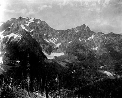
Big Four Mountain with Hall Peak to right, Big Four Inn in lower right. ca 1923
-
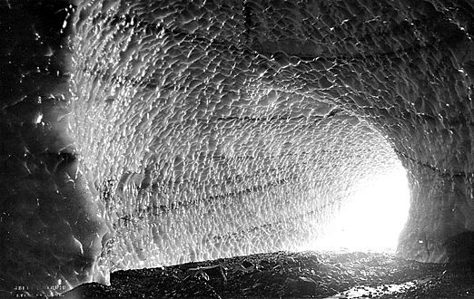
One of Big Four's ice caves, ca. 1920.
-
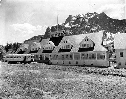
Big Four Inn and mountain
-
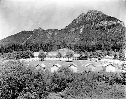
Pemmican Peak, Big Four Inn and cabins
-
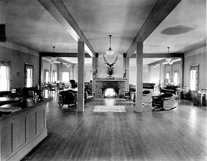
Big Four Inn lobby

.jpeg)

.jpeg)
.jpeg)
.jpeg)
