
Hall Peak (Washington) facts for kids
Quick facts for kids Hall Peak |
|
|---|---|

Hall Peak
|
|
| Highest point | |
| Elevation | 5,484 ft (1,672 m) |
| Prominence | 964 ft (294 m) |
| Geography | |

Hall Peak
Location in Washington (state)

Hall Peak
Location in the United States
|
|
| Parent range | North Cascades Cascade Range |
| Topo map | USGS Silverton |
| Geology | |
| Age of rock | 260 to 370 million years |
| Type of rock | phyllitic slate, argillite |
| Climbing | |
| First ascent | 1927, Art Winder |
| Easiest route | Scrambling Southeast ridge |
Hall Peak is a mountain in Washington state, in the U.S.. It stands about 5,484 feet (1,671 meters) tall. You can find it in Snohomish County, near the western edge of the North Cascades mountains.
This peak is located close to the South Fork Stillaguamish River Valley. It's also about 5 miles (8 km) northwest of Barlow Pass. The mountain is part of the Mount Baker-Snoqualmie National Forest.
Hall Peak is named after George Hall, a mining prospector. In 1891, he found a valuable mining claim called "Forty Five" in the area.
Seeing Hall Peak
You can easily see Hall Peak from the Big Four picnic area. This spot is also where the trail to the famous Big Four Ice Caves begins. Hall Peak's closest taller neighbor is Big Four Mountain, which is just one mile away.
Weather at Hall Peak
Hall Peak is in a place with a "marine west coast" climate. This means it gets a lot of weather from the Pacific Ocean. Most weather systems travel from the ocean towards the Cascade Mountains.
When these weather systems hit the tall Cascade peaks, they are forced to rise. This makes them drop their moisture as rain or snow. Because of this, the western side of the North Cascades gets a lot of precipitation. This is especially true in winter, when there's a lot of snowfall.
The weather here is usually mild. Temperatures rarely go below 0°F (-18°C) or above 80°F (27°C). Winters are often cloudy, but summers are usually clear and sunny. The snow here tends to be wet and heavy. This can sometimes lead to a high risk of avalanches.
How the Mountains Formed
The North Cascades mountains have very rugged and dramatic shapes. They feature sharp peaks, long ridges, and deep valleys carved by glaciers. These amazing shapes were created by geological events that happened millions of years ago.

The Cascade Mountains started forming a very long time ago, during the late Eocene Epoch. This happened because the North American Plate was slowly moving over the Pacific Plate. This movement caused a lot of volcanic activity.
Also, small pieces of the Earth's crust, called terranes, came together. These pieces helped create the North Cascades about 50 million years ago.
Later, during the Pleistocene period (which started over two million years ago), glaciers played a big role. These huge sheets of ice moved back and forth many times. As they moved, they scraped and shaped the land. This is why many river valleys in the area have a "U" shape.
The combination of land being pushed up (called uplift) and cracks in the Earth's crust (called faulting), along with the glaciers, created the tall peaks and deep valleys we see today in the North Cascades.
Images for kids
-
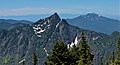
East side of Hall Peak, with Mt. Pilchuck in the distance.

