
Sauk River (Washington) facts for kids
Quick facts for kids Sauk River |
|
|---|---|

The Sauk River along SR530, north of Darrington, Washington
|
|


Location of the mouth of the Sauk River in Washington
|
|
| Country | United States |
| State | Washington |
| County | Skagit, Snohomish |
| Physical characteristics | |
| Main source | North Fork and South Fork confluence Cascade Range 1,204 ft (367 m) 48°5′59″N 121°23′28″W / 48.09972°N 121.39111°W |
| River mouth | Skagit River 217 ft (66 m) 48°28′53″N 121°36′20″W / 48.48139°N 121.60556°W |
| Length | 45 mi (72 km) |
| Basin features | |
| Basin size | 714 sq mi (1,850 km2) |
The Sauk River is a river in northwestern Washington, United States. It flows for about 45 miles (72 kilometers). The Sauk River is a "tributary," which means it's a smaller river that flows into a larger one. In this case, it flows into the Skagit River.
This river helps drain a large area of the high Cascade Range mountains. This area is part of the Puget Sound watershed, located north of Seattle. The Sauk River is a popular spot for fly fishing. It is also recognized as a National Wild and Scenic River, which means it's protected for its natural beauty and importance.
The Sauk River starts from two main branches, called "forks." These forks begin in the Glacier Peak Wilderness area of eastern Snohomish County. The two forks meet at a place called Bedal to form the main Sauk River. From there, the river flows northwest through a wild part of the Mount Baker-Snoqualmie National Forest. It passes by the town of Darrington and then flows north. Finally, it joins the Skagit River from the south near Rockport.
Along its journey, the Sauk River gets water from other rivers. The Suiattle River joins it from the east about 12 miles (19 km) south of Rockport. The White Chuck River flows into it just before Darrington. Another important stream, Clear Creek, also joins the Sauk River near Darrington.
Interestingly, near Darrington, the Sauk River gets very close to the start of the North Fork Stillaguamish River. In the past, people used to carry their boats across this small piece of land between the two rivers.
The name "Sauk" comes from the Sah-kee-ma-hu people. They are part of the Sauk-Suiattle tribe, who are related to the Skagit tribes. This name is different from the Sauk tribe who live in the Midwestern U.S.
Contents
Exploring the South Fork Sauk River

The South Fork Sauk River begins high up in the mountains. Its water comes from a glacier on the northwest side of Columbia Peak. The river generally flows northwest through a valley called Seventysix Gulch. It reaches Monte Cristo, where it is joined by Glacier Creek.
The South Fork continues flowing northwest until Weden Creek adds its water. Then, the river turns north. It flows just east of Barlow Pass, and the Mountain Loop Highway runs alongside it for a while. After several miles, the river enters Monte Cristo Lake. You can find many camping spots along the South Fork Sauk River north of Monte Cristo Lake. Near Bedal Campground, the South Fork meets the North Fork. This is where the main Sauk River officially begins.
There's a very short and low mountain pass called Barlow Pass. It separates the South Fork Sauk River from Palmer Creek, which is a stream that feeds the South Fork Stillaguamish River. This unusual geography suggests that a very long time ago, during the Ice Age, the Sauk River might have flowed west through Barlow Pass into what is now the Stillaguamish valley.
Streams Joining the South Fork
- Glacier Creek: This creek joins the South Fork at Monte Cristo.
- Weden Creek: It joins the South Fork about 2.3 miles (3.7 km) downstream from Monte Cristo.
- Elliot Creek: This creek joins just downstream from where Monte Cristo Lake flows out.
Discovering the North Fork Sauk River

The North Fork is the larger of the two main branches of the Sauk River. It starts from a small, unnamed lake near Johnson Mountain, across from Blue Lake. For most of its path, it flows generally northwest.
As it gets closer to where it meets the South Fork, it turns west. It then rushes through a narrow canyon, creating the powerful North Fork Falls. This waterfall plunges at least 58 feet (18 meters) down. A short distance below, it also drops over smaller Lower North Fork Falls. The North Fork joins the South Fork near Bedal Campground, forming the main Sauk River.
Some experts, like Fred Beckey, believe that the true source of the North Fork could also be considered Cadet Creek. Cadet Creek flows into the North Fork through another stream called Sloan Creek.
Streams Joining the North Fork
- Sloan Creek: This creek joins the North Fork about 2.1 miles (3.4 km) above Lost Creek.
- Cadet Creek: This stream flows from the northeast side of Monte Cristo Peak.
- Cougar Creek: This creek flows from Cougar Lake, which is on the east side of Bedal Peak.
- Lost Creek: This creek joins the North Fork about 3.5 miles (5.6 km) above where the North Fork meets the South Fork.
History of the Sauk River Area

In 1890, people looking for valuable minerals, called prospectors, explored north from the Skykomish River area. Their discoveries led to a "mining boom" at Monte Cristo. This mining town was located near where the North Fork Sauk River begins.
It was hard to reach Monte Cristo from the south. Because of this, a narrow wagon road was built in 1891 along the Sauk River. This road went from Sauk City on the Skagit River all the way to the mines at Monte Cristo. A very important stop on this road was a trading post called Orient, located where the two forks of the Sauk River meet. Today, this area is known as Bedal.
Today, the Mountain Loop Highway follows part of the Sauk River. It runs more or less along the same path as that old wagon road.
Images for kids
-
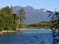
The Sauk River along SR530, north of Darrington, Washington
-
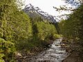
South Fork from entrance to Monte Cristo townsite
-
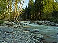
The North Fork of Sauk River
-
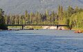
SR530 Sauk River Bridge
