
Murgenthal facts for kids
Quick facts for kids
Murgenthal
|
||
|---|---|---|
 |
||
|
||

Murgenthal
Location in Switzerland

Murgenthal
Location in Canton of Aargau
|
||
| Country | Switzerland | |
| Canton | Aargau | |
| District | Zofingen | |
| Area | ||
| • Total | 18.62 km2 (7.19 sq mi) | |
| Elevation | 412 m (1,352 ft) | |
| Population
(Dec 2020 )
|
||
| • Total | 2,959 | |
| • Density | 158.92/km2 (411.59/sq mi) | |
| Postal code |
4853
|
|
| Surrounded by | Boningen (SO), Brittnau, Fulenbach (SO), Pfaffnau (LU), Roggwil (BE), Rothrist, Vordemwald, Wolfwil (SO), Wynau (BE) | |

Murgenthal is a municipality (like a town or district) in Switzerland. It's located in the canton of Aargau and is part of the Zofingen district. Murgenthal is known for its interesting history and its important location where the Murg and Aare rivers meet.
Contents
- Murgenthal's Past: A Look at Its History
- Murgenthal's Landscape: Exploring Its Geography
- Murgenthal's Symbol: The Coat of Arms
- Who Lives in Murgenthal: Demographics
- Murgenthal's Work Life: The Economy
- Beliefs in Murgenthal: Religion
- Learning in Murgenthal: Education
- Getting Around: Transportation
- The Murgenthal Status: Managing River Flow
- See also
Murgenthal's Past: A Look at Its History

Murgenthal was first mentioned in old records in 1255. Back then, it was called Murgatun. The control over the village first belonged to the Counts of Frohburg. In 1299, it passed to the powerful Habsburg family.
Changes in Control and Important Projects
From 1415 to 1798, the city of Bern ruled Murgenthal. During this time, between 1640 and 1645, an important project happened. The Governor of Aarburg, Jacob Wyss, built the Rotkanal (Red Canal). This canal was about 8.5 kilometers (5.3 miles) long. It carried water from the Murg river to the fields near Rothrist. This helped farmers water their crops.
After Bern's rule, Murgenthal was part of the Canton of Bern from 1798 to 1802. Since 1803, it has been part of the Aargau canton. Until 1900, Murgenthal village was part of a larger municipality called Riken. In 1901, Riken and another municipality, Balzenwil, joined together. They formed the new municipality we know today as Murgenthal.
Religious Life and New Churches
Under Bernese rule, people in Murgenthal were part of church areas called parishes in Wynau and Roggwil. In 1817, a new parish was created just for Murgenthal. In 1901, its name was changed to the Riken Murgenthal parish. A church was built in Glashütten between 1852 and 1854. It was designed in the Romanesque Revival style. However, a new church building replaced it in 1964.
Growth with Railways and Factories
A big change for Murgenthal came in 1857. A railway station was built on the line connecting Olten and Bern. This made it easier for people and goods to travel. In 1863, a wooden bridge was built over the Aare river to Fulenbach.
With the railway and access to the Rotkanal, many factories started in Murgenthal. In 1856, the Grossmann weaving factory opened. Later, it became Künzli & Co. In 1881, Arnold Künzli started a knitting factory called His & Cie. This factory operated in Murgenthal until 1976. Another factory that made wicker and wood products opened in 1894.
The village kept growing because of these new industries. By 1920, about 63% of the people working in Murgenthal had jobs in manufacturing. However, by 2005, this number had dropped to only 28%. Many factories closed, and the number of jobs in the municipality fell. In 1950, there were 1,485 jobs, but now there are about half that number.
Schooling in Murgenthal
The first village school in Murgenthal started in the 17th century. Over time, more school buildings were constructed. School houses were built in Glashütten in 1825, in Balzenwil in 1826, in Riken in 1842, and in Murgenthal itself in 1883.
Murgenthal's Landscape: Exploring Its Geography
_029.jpg)
Murgenthal covers an area of about 18.65 square kilometers (7.2 square miles). A large part of this land is covered by forests. About 62.8% of the area is forested, which is about 11.71 square kilometers (4.52 square miles).
Land Use and Natural Features
Around 27.8% of Murgenthal's land is used for farming. This includes fields for growing crops and pastures for animals. About 8.1% of the land is settled, meaning it has buildings or roads. A small part, 1.2%, is made up of rivers or lakes. Most of the water in the municipality is flowing water, like rivers.
Location and Hamlets
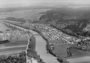
Murgenthal is located in the Zofingen district. It sits right where the Murg river flows into the larger Aare river. This location is also on the border between the Canton of Aargau and the Canton of Bern. The municipality includes the main village of Murgenthal and several smaller communities called hamlets. These hamlets are Walliswil, Balzenwil, Glashütten, and Riken.
Murgenthal's Symbol: The Coat of Arms
The blazon (official description) of Murgenthal's municipal coat of arms is: "Azure three Trefoils slipped Argent issuant from Coupeaux Vert and in Chief a Cross pattee couped of the second." This means it has a blue background with three silver clover leaves growing from green hills. At the top, there is a silver cross with wide, flat ends.
Who Lives in Murgenthal: Demographics

Murgenthal has a population of about 2,847 people (as of December 2006). Around 15.3% of the people living here are foreign nationals. Over the last ten years (1997–2007), the population has changed slightly, decreasing by about 0.5%.
Languages Spoken
Most people in Murgenthal speak German, which is about 90.7% of the population. The second most common language is Albanian, spoken by 2.8% of residents. Italian is the third most common language, spoken by 2.2% of the population.
Age Groups in the Community
In 2008, the population of Murgenthal was divided into different age groups:
- Children aged 0-9: 9.2% (263 children)
- Teenagers aged 10-19: 11.6% (332 teenagers)
- Young adults aged 20-29: 13.5% (387 people)
- Adults aged 30-39: 13.8% (397 people)
- Adults aged 40-49: 16.1% (461 people)
- Adults aged 50-59: 15.1% (433 people)
- Seniors aged 60-69: 9.4% (271 people)
- Seniors aged 70-79: 6.9% (198 people)
- Seniors aged 80-89: 3.7% (106 people)
- Seniors aged 90 and older: 0.8% (22 people)
Homes and Households
In 2000, the average number of people per living room was 0.56. This means that on average, there was a bit more than one person for every two rooms. About 59.8% of homes were owned by the people living in them.
In 2000, there were 1,039 private households (homes and apartments) in Murgenthal. The average household had 2.5 people. In 2008, there were 538 single-family homes, making up 44.1% of all homes and apartments. There were also 62 empty apartments, which means about 5.1% of homes were available. In 2007, new housing units were being built at a rate of 3.2 new homes for every 1000 residents.
Voting Habits
In the 2007 federal election, the most popular political party was the SVP. They received 48.67% of the votes. The next two popular parties were the SP (13.32%) and the FDP (12.83%). A total of 854 votes were cast in this election. About 43.5% of eligible voters participated.
Historical Population Figures
Here's how Murgenthal's population has changed over time:
| Historical population | ||
|---|---|---|
| Year | Pop. | ±% |
| 1764 | 773 | — |
| 1910 | 2,171 | +180.9% |
| 1950 | 2,638 | +21.5% |
| 1980 | 2,537 | −3.8% |
| 1990 | 2,715 | +7.0% |
| 2000 | 2,741 | +1.0% |
Murgenthal's Work Life: The Economy
In 2007, Murgenthal had a low unemployment rate of 2.46%. This means most people who wanted jobs had them.
Types of Jobs
In 2005, jobs in Murgenthal were divided into three main types:
- Primary sector: 99 people worked in this sector, which includes farming and forestry. There were about 40 businesses in this area.
- Secondary sector: 221 people worked in this sector, which includes manufacturing and construction. There were 41 businesses here.
- Tertiary sector: 483 people worked in this sector, which includes services like shops, offices, and schools. There were 110 businesses in this area.
Commuting to Work
In 2000, 1,412 workers lived in Murgenthal. Out of these, 992 (about 70.3%) traveled outside Murgenthal for work. At the same time, 419 people came into Murgenthal to work. There were a total of 839 jobs available in the municipality (for at least 6 hours per week). For getting to work, 10.1% of people used public transportation, and 53.7% used a private car.
Beliefs in Murgenthal: Religion
Based on the 2000 census, here's a look at religious groups in Murgenthal:
- 577 people (21.1%) were Roman Catholic.
- 1,574 people (57.4%) belonged to the Swiss Reformed Church.
- A small number, 3 people (0.11%), belonged to the Christian Catholic faith.
Learning in Murgenthal: Education
About 70.1% of adults in Murgenthal (between ages 25 and 64) have completed either high school or higher education, like university.
Schooling for Students
In the 2008/2009 school year, there were 185 students attending primary school in Murgenthal. There were also 66 students attending secondary school in the municipality.
The Local Library
Murgenthal has its own library called the Schul-u.Gde.Bibliothek Murgenthal (school and municipal library of Murgenthal). In 2008, the library had 4,422 books and other media items. It loaned out 4,166 items that year. The library was open for a total of 131 days, averaging 4 hours per week.
Getting Around: Transportation
Murgenthal has a railway station, Murgenthal. This station is on the Olten–Bern line. You can catch regular trains from here to Langenthal and Baden.
The Murgenthal Status: Managing River Flow
The Murgenthal Status is a special rule about the flow of the Aare river. It says that the Aare river's flow should not go over 850 cubic meters per second (30,000 cubic feet per second). This measurement is taken at the Murgenthal station, which is located after the Aare river joins with the Emme river.
Why the Status is Important
When the Emme river gets very full, its water adds to the Aare river. This can make the Aare river flow too fast and cause floods downstream in the cantons of Solothurn and Aargau.
So, the Murgenthal Status helps control the Aare's speed. If the river starts flowing too fast, a special dam called the regulating dam Port must limit the Aare's flow upstream. The water that would cause flooding is then stored in the three Seeland lakes. These lakes act like giant sponges, holding the extra water until the Emme river's high flow goes down. This system was improved with the Flumenthal dam during the Second Jura water correction, making it even better at preventing floods.
See also
 In Spanish: Murgenthal para niños
