Murton Fell facts for kids
Quick facts for kids Murton Fell |
|
|---|---|

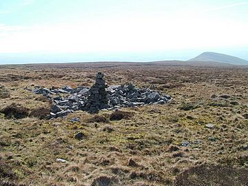
Stones near the summit
|
|
| Highest point | |
| Elevation | 675 m (2,215 ft) |
| Prominence | 74 m (243 ft) |
| Parent peak | Mickle Fell |
| Listing | Simm, Hewitt, Nuttall |
| Geography | |
| Location | North Pennines, England |
| Parent range | Lon: |
| OS grid | NY753245 |
| Topo map | OS Outdoor Leisure 19 |
Murton Fell is a cool hill in the North Pennines area of England. It stands tall at 675 meters (about 2,215 feet) above the village of Murton in Cumbria. This hill is part of the beautiful Eden region.
About Murton Fell
Murton Fell is a significant hill located in the stunning North Pennines of England. It rises high above the small village of Murton, which is in the county of Cumbria. The hill is 675 meters (2,215 feet) tall. It offers amazing views of the surrounding countryside.
Location and Features
This hill is found in the eastern part of the Eden area. It sits just east of a really dramatic valley called High Cup Nick. This area is known for its rugged beauty and interesting rock formations. Hikers often enjoy exploring the paths around Murton Fell.
Water Flow
Murton Fell is special because it lies on the central watershed of England. This means that rain and melted snow falling on the hill flow in different directions. Water on the southwest side of the hill flows into the River Eden. This river eventually reaches the Solway Firth, which is an inlet of the Irish Sea.
On the other hand, water falling on the northeast side of Murton Fell flows into the River Tees. The River Tees then travels eastward and empties into the North Sea. This makes Murton Fell a natural dividing line for water flowing across England.
 | Madam C. J. Walker |
 | Janet Emerson Bashen |
 | Annie Turnbo Malone |
 | Maggie L. Walker |


