Muscocho Lake facts for kids
Quick facts for kids Muscocho Lake |
|
|---|---|

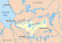
Watershed of Broadback River
|
|
| Location | Eeyou Istchee James Bay Regional Government |
| Coordinates | 49°39′46″N 74°34′03″W / 49.66278°N 74.56750°W |
| Type | Natural |
| Primary inflows |
|
| Primary outflows | Obatogamau River |
| Basin countries | Canada |
| Max. length | 10.3 kilometres (6.4 mi) |
| Max. width | 1.7 kilometres (1.1 mi) |
| Surface elevation | 365 metres (1,198 ft) |
Muscocho Lake is a lake in Quebec, Canada. The Obatogamau River flows through it. You can find this lake in the Eeyou Istchee James Bay area. It stretches across two regions called Fancamp and Haüy.
The main job around the lake is forestry, which means managing forests and cutting trees. After that, fun activities like tourism are also important.
You can get to Muscocho Lake using a forest road called R1040. This road connects to Highway 113 and the Canadian National Railway. The Haüy region is located north of the lake.
The lake's surface usually freezes from early November. It stays frozen until mid-May. However, it's generally safe to walk on the ice from mid-November to mid-April.
About Muscocho Lake's Geography
Muscocho Lake is about 10.3 kilometres (6.4 mi) long. It is also 1.7 kilometres (1.1 mi) wide at its widest point. The lake sits at an elevation of 365 metres (1,198 ft) above sea level. This is the same height as the Obatogamau Lakes upstream.
The lake has an interesting angled shape. This is because a long piece of land, a peninsula, sticks out into it for about 5.0 kilometres (3.1 mi). Muscocho Lake has 31 islands. The biggest island is about 1.1 kilometres (0.68 mi) long.
Muscocho Lake is part of the Obatogamau River. This river eventually flows into the Chibougamau River. The lake gets its water from the south side, in the Fancamp area. Upstream, other lakes like Lac Verneuil, Le Royer, La Dauversière, Holmes, and Chevrier Lake (Obatogamau River) feed into the Obatogamau River.
The water leaves Muscocho Lake through a short narrow passage. This passage has an island in it. This exit point is located:
- 7.4 kilometres (4.6 mi) east of Eau Jaune Lake.
- 17.9 kilometres (11.1 mi) east of Presqu'île Lake (Nord-du-Québec).
- 65.4 kilometres (40.6 mi) east of where the Obatogamau River meets the Chibougamau River.
- 96.4 kilometres (59.9 mi) north-east of where the Chibougamau River meets the Opawica River.
- 32.4 kilometres (20.1 mi) south-west of downtown Chibougamau.
- 19.6 kilometres (12.2 mi) south-east of the village of Chapais, Quebec.
Nearby Rivers and Lakes
Many rivers and lakes are close to Muscocho Lake. Here are some of the main ones:
- North side: Goudreau Lake, Lac Simon, Chevrillon Lake, Dorés Lake (Chibougamau River), Chibougamau Lake, Chibougamau River.
- East side: La Dauversière Lake, Chevrier Lake (Obatogamau River), Boisvert River.
- South side: Obatogamau Lakes, Caopatina Lake, Verneuil lake, Opawica River, Nemenjiche River.
- West side: Eau Jaune Lake, Presqu'île Lake (Nord-du-Québec), Irene River, Obatogamau River.
The Name of Muscocho Lake
The name "Muscocho" first appeared on maps in 1927. It comes from the Cree language. Its meaning is similar to "herbs" or "grass." The word "Muscocho" might come from "maskusiy," which means any kind of grass or hay. A person named Father Louis-Philippe Vaillancourt said that in Cree, "miskoskou" means "there is a lot of grass."
The official name "Lake Muscocho" was made formal on December 5, 1968. This happened when the Commission de toponymie du Québec was created.
 | May Edward Chinn |
 | Rebecca Cole |
 | Alexa Canady |
 | Dorothy Lavinia Brown |


