
Obatogamau River facts for kids
Quick facts for kids Obatogamau |
|
|---|---|

Watershed of Nottaway River
|
|
| Country | Canada |
| Province | Quebec |
| Region | Nord-du-Québec |
| Physical characteristics | |
| Main source | Obatogamau Lakes Eeyou Istchee Baie-James, Nord-du-Québec, Quebec 365 m (1,198 ft) 49°37′38″N 74°31′28″W / 49.62722°N 74.52444°W |
| River mouth | Chibougamau River Eeyou Istchee Baie-James, Nord-du-Québec, Quebec 320 m (1,050 ft) 49°48′20″N 75°30′21″W / 49.80556°N 75.50583°W |
| Length | 130.7 km (81.2 mi) |
| Basin features | |
| Tributaries |
|
The Obatogamau River is a river in Quebec, Canada. It flows into the Chibougamau River. This river is part of the Nord-du-Québec region.
You can reach the lower and middle parts of the Obatogamau River by Route 113. This road connects Lebel-sur-Quévillon to Chibougamau. The northeast side of Obatogamau Lakes is reached by Route 167. This road also follows part of the Obatogamau River valley.
The Obatogamau River usually freezes from early November. It stays frozen until mid-May. However, it's generally safe to travel on the ice from mid-November to mid-April.
Contents
River's Path and Surroundings
The Obatogamau River starts from the Obatogamau Lakes. These lakes are about 19.6 km long. They are located at an elevation of 365 meters. The lakes have a complex shape with many islands and bays. The largest bay is Anderson Bay.
The river's source is located:
- About 11.6 km south of a bay in Chibougamau Lake.
- About 29.3 km southeast of Chapais, Quebec.
- About 34.1 km south of Chibougamau.
The Obatogamau River flows for about 130.7 km. It goes through different sections.
Upper Part of the River
This section is about 34.1 km long. It flows through areas called Fancamp, Haüy, Brongniarat, and Brochant.
- It flows north for 5.3 km, then southwest for 4.0 km.
- It crosses Muscocho Lake for 10.5 km.
- It then crosses Keith Lake for 2.9 km.
- Finally, it flows west for 11.4 km through the "Lac à l’Eau Jaune" (Lake of Yellow Water).
Middle Part of the River
This section is about 53.8 km long. It flows through the De Brochant and D'Anville areas.
- It flows northwest for 8.0 km.
- It then passes through Presqu'île Lake (Nord-du-Québec) for 6.8 km.
- It continues west for 20.0 km, making two large curves.
- It then flows north, then southwest for 19.0 km. This part goes through marshy areas.
Lower Part of the River
This section is about 42.8 km long. It flows through the D'Anville, Dolomieu, and Saussure areas.
- It flows west for 22.5 km to Lake Society.
- It then goes southwest for 1.4 km through a marshy zone.
- It flows west for 7.6 km, forming a curve to the north.
- Finally, it flows west for 11.3 km, making three curves to the north, until it reaches its mouth.
The Obatogamau River joins the Chibougamau River. This meeting point is near the Route 113 bridge. From this point, the water flows southwest along the Chibougamau River for 41.4 km. It then joins the Opawica River. After that, the water flows generally west through the Waswanipi River. This river eventually reaches Goéland Lake (Waswanipi River). The Waswanipi River then flows into Matagami Lake.
The mouth of the Obatogamau River is located:
- About 35.5 km northeast of where the Chibougamau River meets the Opawica River.
- About 82.4 km southeast of downtown Chibougamau.
What's in the Area?
The main water areas near the Obatogamau River include:
- North: Chibougamau River, Merrill Lake, Opémisca Lake.
- East: Boisvert River, Chevrier Lake.
- South: Rohault Lake, Nemenjiche River.
- West: Chibougamau River, Inconnu Lake, Opawica Lake, Wachigabau Lake.
River's Name and History
The name "Obatogamau" comes from the Cree language. It means "tightened by wood" or "tightened by vegetation." This name was shown on a map from 1941.
The name "Obatogamau River" was officially recognized on December 5, 1968. This happened when the Commission de toponymie du Quebec was created.
Images for kids
-
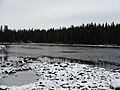
Rivière Obatogamau

