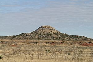
Mushaway Peak facts for kids
Quick facts for kids Mushaway Peak |
|
|---|---|

Mushaway Peak viewed from the west
|
|
| Highest point | |
| Elevation | 2,851 ft (869 m) |
| Prominence | 380 ft (120 m) |
| Geography | |
| Topo map | Mushaway Peak Quadrangle |
| Geology | |
| Age of rock | Quaternary, Cretaceous |
| Mountain type | Butte |
Mushaway Peak is a small but easy-to-spot butte (which is like a flat-topped hill with steep sides). It's found about 4 miles (6.4 km) southeast of Gail in the middle of Borden County, Texas. This peak is one of the oldest and most famous natural sights in the area.
About Mushaway Peak
The very top of Mushaway Peak reaches about 2,851 feet (869 meters) above sea level. This height is similar to the High Plains of the Llano Estacado, which is a large, flat area about 10 miles (16 km) to the northwest.
How Mushaway Peak Formed
Mushaway Peak is actually what's left of a much bigger flat area called the Llano Estacado. Over a very long time, water and wind slowly wore away the land around it. This process is called erosion. The top of Mushaway Peak has a strong, hard layer of rock that protected the softer rock underneath. Because of this tough cap, the peak stayed standing while the land around it was washed away by Grape Creek and Bull Creek. These creeks are small rivers that flow into the upper Colorado River.
The Many Names of Mushaway Peak
Mushaway Peak has been called many different names throughout history. Some of these names include Cordova Mountain, Mount Irwin, Muchakooay Peak, and even Old Baldy.
In 1936, a group called the United States Board on Geographical Names suggested that "Muchakooay Peak" should be the official name. However, they changed their minds in 1973. That's when "Mushaway Peak" was chosen as the official name for this important landform.
 | Jessica Watkins |
 | Robert Henry Lawrence Jr. |
 | Mae Jemison |
 | Sian Proctor |
 | Guion Bluford |


