
Mussel Rock facts for kids

Mussel Rock seen from the beach of the eponymous Mussel Rock Park.
|
|

Mussel Rock
Location in San Francisco

Mussel Rock
Location in San Francisco Bay Area

Mussel Rock
Location in California

Mussel Rock
Location in the United States
|
|
Quick facts for kids Geography |
|
|---|---|
| Location | Northern California |
| Coordinates | 37°40′01″N 122°29′50″W / 37.66694°N 122.49722°W |
| Highest elevation | 60 ft (18 m) |
| Administration | |
| State | |
| County | San Mateo |
| City | Daly City |
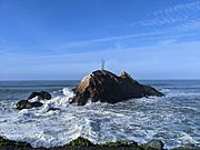
Mussel Rock is a cool rock formation located right off the coast of Daly City, California. It's a type of rock called a sea stack. This means it's a tall, isolated rock island that was once part of a larger cliff. Over time, the ocean waves wore away the softer parts of the land, leaving this strong rock standing alone.
Mussel Rock is about 15 meters (50 feet) from the shore and stands 18 meters (60 feet) tall. The area next to it is Mussel Rock Park, a large space with a beach, hiking trails, and even a spot for paragliding.
This rock is famous for a big reason: it's the closest point to where the powerful 1906 San Francisco earthquake began. It's also where the huge San Andreas Fault comes onto the land from the ocean. This makes Mussel Rock a very important spot for understanding California's geology!
Contents
What is Mussel Rock?
Mussel Rock is a sea stack, which is like a natural pillar of rock in the ocean. It formed when strong ocean waves slowly eroded a rocky headland. The softer rock wore away, but the harder rock remained, standing tall like an island.
The rock itself is made of very old, tough rock called greenstone. This greenstone formed about 80 to 90 million years ago. It's much older and stronger than the softer sedimentary rocks found nearby. This strength helps it resist the ocean's powerful waves.
How Mussel Rock Formed
Mussel Rock began to form around 145 million years ago. This happened because of the movement of Earth's giant tectonic plates. The Pacific Plate was pushing against the Farallon plate, forcing it to slide underneath the North American plate. This process is called subduction.
As the Farallon plate slid down, pieces of its top layer broke off. These broken rocks piled up along the edge of the North American plate. Mussel Rock is one of these ancient, tough pieces of rock that got caught between the moving plates.
Famous writer John McPhee wrote about Mussel Rock in his book Assembling California. He described it as a "horse," which in geology means a piece of rock caught within a fault. He noted that it was "like a three-story building, standing in the Pacific."
The San Andreas Fault Connection
Mussel Rock is a key location because it's where the famous San Andreas Fault meets the ocean. The San Andreas Fault is a very long crack in the Earth's crust where two large tectonic plates slide past each other. This movement causes earthquakes.
The area around Mussel Rock is where several different types of rock meet. The softer sandstone rocks in the area are much younger, only about 2 to 3 million years old. These softer rocks lie on top of the much older greenstone of Mussel Rock. The San Andreas Fault separates these different rock types at the surface.
Landslides and Erosion

The cliffs around Mussel Rock are always changing. This area is known for frequent landslides. This happens because the ground is made of loosely packed rock and soil. Also, the constant movement along the San Andreas Fault and another smaller fault, the Mussel Rock Fault, contributes to the instability.
Ocean waves and strong winds also cause coastal erosion. During El Niño years, when there are more powerful storms, the coastline can erode by up to 2 to 3 feet each year. This erosion, combined with earthquake activity, makes the cliffs above Mussel Rock a very active landslide zone. This can be a concern for homes built on the clifftops.
Gallery
- Media of Mussel Rock
-
Mussel Rock, as seen from Mori Point in Pacifica, California. (July 2006)
-
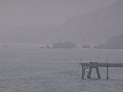
Mussel Rock seen from the beach of the eponymous Mussel Rock Park. (January 2021)
-
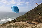
A pair of paragliders take flight at Mussel Rock Beach near Daly City, California.
-
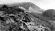
Landslide on the cliffs near Mussel Rock as a result of the 1906 San Francisco earthquake.
-
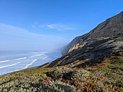
Coastal bluffs facing the pacific, photographed from a trail in Mussel Rock Park.
-
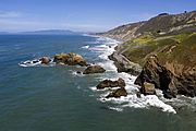
An aerial photo of Mussel Rock.
-
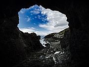
Low tide inside Tobin's Tunnel, a man-made stone tunnel near Mussel Rock.


.jpg)

Images for kids
-
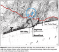
A map detailing Mussel Rock and the surrounding coastline in 1853.

