
Musselburgh facts for kids
Quick facts for kids Musselburgh
|
|
|---|---|
 Rennie Bridge over the River Esk |
|
| Lua error in Module:Location_map at line 420: attempt to index field 'wikibase' (a nil value).Lua error in Module:Location_map at line 420: attempt to index field 'wikibase' (a nil value). | |
| Population | 21,100 (2020) |
| • Edinburgh | 5 mi (8 km) |
| • London | 329 mi (529 km) |
| Civil parish |
|
| Council area |
|
| Lieutenancy area | |
| Country | Scotland |
| Sovereign state | United Kingdom |
| Post town | MUSSELBURGH |
| Postcode district | EH21 |
| Dialling code | 0131 |
| Ambulance | Scottish |
| EU Parliament | Scotland |
| UK Parliament |
|
| Scottish Parliament |
|

Musselburgh is the biggest town in East Lothian, Scotland. It sits on the coast of the Firth of Forth, about 8 kilometers (5 miles) east of Edinburgh city centre. The town is home to around 21,500 people.
Contents
History of Musselburgh
The name Musselburgh comes from Old English words. Mussel refers to the shellfish, and burgh means a fortified town, like Edinburgh. Long ago, it was also called Eskmuthe because it's at the mouth of the River Esk.
Roman Times and Ancient Bridges
The Romans first settled in Musselburgh around 80 CE. They built a fort near the River Esk at Inveresk. They also built a bridge over the Esk, which was very important for their travels.
This Roman bridge was rebuilt many times over the centuries. Today, the Old Bridge is still used by people walking. A newer bridge, designed by John Rennie the Elder, was built in 1806.
The "Honest Toun"
Musselburgh is famous for being called "The Honest Toun." This nickname comes from a story in 1332. The leader of Scotland, Randolph, Earl of Moray, was very sick in Musselburgh. The townspeople took great care of him.
When he died, the new leader offered them a reward for their kindness. But the people refused, saying they were just doing their duty. The new leader was so impressed that he called them "honest men." Every year, Musselburgh celebrates this by choosing an "Honest Lad" and "Honest Lass."
Growth and Development
Over the years, Musselburgh has grown a lot. Many new homes were built in the later part of the 20th century.
A famous battle, the Battle of Pinkie, happened south of Musselburgh in 1547. This was part of a conflict between Scotland and England.
Town Governance
Before 1975, Musselburgh had its own town council. This council was in charge of things like housing, street cleaning, and lighting. The head of the council was called the Provost. After 1975, Musselburgh became part of the East Lothian council area.
People of Musselburgh
Population and Background
In 2022, Musselburgh had a population of 21,479. Most residents (about 79%) were born in Scotland. About 9.5% were from other parts of the UK, and 7.2% from Europe.
Religion in Musselburgh
Many people in Musselburgh have a religion. In 2011, about 52% of residents said they belonged to a religion, with most being Christians. There are several churches in the town for different Christian groups.
Churches
- Church of Scotland: There are three Church of Scotland churches: North Esk, St. Andrew's High, and St. Michael's, Inveresk.
- Roman Catholic: There is one Roman Catholic church, Our Lady of Loretto and St Michael.
- Scottish Episcopal Church: St Peter's Church is the Scottish Episcopal congregation.
- Other Churches: Other churches include Harbour Church, Hope Church, Musselburgh Baptist Church, and Musselburgh Congregational Church.
Education
Musselburgh has several schools. Loretto School is a private boarding school. Musselburgh Grammar School is a large public high school, and it's one of the oldest in the country, dating back to 1608.
There are also several primary schools: Campie Primary School, Musselburgh Burgh Primary School, Stoneyhill Primary School, Pinkie St Peter's Primary School, and Loretto RC Primary School. For younger children, there are private nurseries and early learning centers.
Queen Margaret University moved its campus to Musselburgh in 2007. The Queen officially opened the university campus in 2008.
Getting Around Musselburgh
.jpg)
.jpg)
Trains
Musselburgh has two train stations. Musselburgh railway station is near Queen Margaret University. It has regular trains to Edinburgh Waverley and North Berwick. This station is fairly new, opening in 1988. The other station is Wallyford railway station, which opened in 1994.
The town's original train station, near the town centre, closed in 1964. Part of the old railway line is now a road.
Buses
Local bus services are provided by Lothian Buses, East Coast Buses, and Prentice Coaches Ltd.
Roads
The A1 main road goes around Musselburgh. It connects to the A720 Edinburgh City Bypass. The A199 road goes through the town's High Street, connecting to Edinburgh in the west and Dunbar in the east.
Sports and Activities
Musselburgh has a rich history in sports.
- Musselburgh Silver Arrow: This is thought to be the oldest sports trophy in the United Kingdom. It dates back to at least 1603 and is competed for every year by the Royal Company of Archers.
- Horse Racing and Golf: The town is home to Musselburgh Racecourse for horse racing. It also has Musselburgh Links golf course, which is one of the oldest continuously played golf courses in the world. It even hosted golf's Open Championship in the past.
- Football: Musselburgh Athletic F.C. is the town's football team. There are also great local teams for young players, like Musselburgh Windsor and Musselburgh Youngstars.
- Rugby: Musselburgh RFC plays rugby in the Scottish Premiership.
- Cycling: The Musselburgh Roads Cycling Club was started in 1936. Many of its riders have won national championships or competed in international events like the Commonwealth Games.
- Darts: Musselburgh has its own local darts league, with many players representing the Lothian team.
- Swimming: The Musselburgh Amateur Swimming Club was founded in 1886. It's a very welcoming club for all ages, training at Musselburgh Sports Centre.
- Floorball: The East Lothian Seagulls, a floorball team in the Scottish Floorball League, are based in Musselburgh. They train and play at Queen Margaret University's sports centre.
Famous People from Musselburgh


- Acting
- James Martin, known for playing Eric in Still Game.
- Callum Kerr, actor and musician.
- Medicine
- David Macbeth Moir, a doctor and writer.
- Military
- John Grieve, who received the Victoria Cross for bravery.
- Writers and Artists
- Alexander Carrick, a sculptor.
- Margaret Oliphant, a novelist and historical writer.
- Sports
- Gary Anderson, a darts player.
- Kenny Miller, a footballer.
- Yvonne Murray, an athlete.
- Colin Nish, a footballer.
- Willie Ormond, a footballer and manager.
- Ross Muir, a professional snooker player.
- Various
- Callum Beattie, a singer-songwriter.
- Rhona Cameron, a comedian.
Areas of Musselburgh
Musselburgh includes several areas like Fisherrow, Inveresk, Levenhall Links, Pinkie, Stoneyhill, Clayknowes, Denholm, Stoneybank, Queen Margaret University Student Village, Monktonhall, and Pinkie Braes.
Twin Towns
Musselburgh is twinned with two towns:
- Champigny-sur-Marne in France
- Rosignano Marittimo in Italy
These towns are also twinned with each other, creating a three-way friendship!
Gallery
-
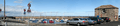
A panoramic view of Fisherrow harbour and its pleasure craft
-
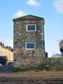
Harbour Master's Office at Fisherrow
-
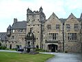
Pinkie House, now one of the buildings of Loretto School
-
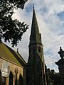
Scottish Episcopal church on the High Street
-
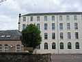
Eskmills, a former factory complex, is transformed into a business park
-
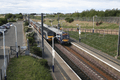
Musselburgh railway station, showing a local eastbound (North Berwick) train, and a westbound (Edinburgh) intercity (125) train
-

Brunton Hall provides access to East Lothian Council's services, as well as a theatre and restaurant
-

Brunton Hall, from the west of the town


See also
 In Spanish: Musselburgh para niños
