
Nagunt Mesa facts for kids
Quick facts for kids Nagunt Mesa |
|
|---|---|

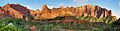
Nagunt Mesa from the west
|
|
| Highest point | |
| Elevation | 7,785 ft (2,373 m) |
| Prominence | 905 ft (276 m) |
| Isolation | 0.90 mi (1.45 km) |
| Parent peak | Timber Top Mountain (8,055 ft) |
| Geography | |

Nagunt Mesa
Location in Utah

Nagunt Mesa
Location in the United States
|
|
| Location | Zion National Park Washington County, Utah, US |
| Parent range | Colorado Plateau |
| Topo map | USGS Kolob Arch |
| Geology | |
| Age of rock | Jurassic |
| Type of rock | Navajo sandstone |
| Climbing | |
| Easiest route | class 5.9 A2+ climbing |
Nagunt Mesa is a tall mountain peak in Zion National Park, Utah. It stands about 7,785-foot (2,373 m) high. You can find it in the beautiful Kolob Canyons part of the park, in Washington County.
What is Nagunt Mesa?
Nagunt Mesa is a large, flat-topped mountain. It is surrounded by huge walls of rock. These walls can be as tall as 1,400 feet (427 meters) in some places. The rock is called Navajo sandstone. This type of rock formed a very long time ago, during the Jurassic period.
The closest taller mountain is Timber Top Mountain. It is about 1.3 mi (2.1 km) to the south. To the north, you can see Paria Point and Tucupit Point. Water from rain and snow on Nagunt Mesa flows into Timber Creek. This creek eventually joins the Virgin River. The name nagunt comes from the Paiute language. It means "bighorn sheep".
Weather and Climate
The best times to visit Nagunt Mesa are in the spring and fall. The weather is usually very nice then. Nagunt Mesa is in a Cold semi-arid climate zone. This means it has a desert climate.
In this area, the coldest month has an average temperature below 32 °F (0 °C). Also, more than half of the yearly rain and snow falls during spring and summer. The desert climate here gets less than 10 inches (250 millimeters) of rain each year. Snowfall in winter is usually light.
Images for kids
-
Kolob Canyons: Beatty Point (left), Nagunt Mesa (left of center), Timber Top Mountain (right)
See also
 In Spanish: Nagunt Mesa para niños
