
Beatty Point (Utah) facts for kids
Quick facts for kids Beatty Point |
|
|---|---|
_(8423923437).jpg)
Southwest aspect
|
|
| Highest point | |
| Elevation | 7,780 ft (2,370 m) |
| Prominence | 140 ft (43 m) |
| Isolation | 0.67 mi (1.08 km) |
| Parent peak | Nagunt Mesa (7,785 ft) |
| Geography | |

Beatty Point
Location in Utah

Beatty Point
Location in the United States
|
|
| Location | Zion National Park Washington County, Utah, US |
| Parent range | Colorado Plateau |
| Topo map | USGS Kolob Arch |
| Geology | |
| Age of rock | Jurassic |
| Type of rock | Navajo sandstone |
| Climbing | |
| Easiest route | class 2 scrambling |
Beatty Point is a tall mountain peak, about 7,780 feet (2,371 meters) high. It's found in the beautiful Zion National Park in Utah, United States. Specifically, it's in the Kolob Canyons area, which is known for its stunning red rock formations.
Contents
About Beatty Point
Beatty Point is surrounded by other cool rock formations. For example, Paria Point is just half a mile (0.8 km) to the north. Nagunt Mesa is also close, about 0.57 miles (0.9 km) to the south. Between these peaks are deep canyons, some as deep as 2,000 feet! Other nearby peaks include Timber Top Mountain and Tucupit Point.
What is it made of?
Beatty Point is mostly made of a type of rock called Navajo sandstone. This rock formed a very long time ago, during the Jurassic period. Underneath the Navajo sandstone, there's another rock layer called the Kayenta Formation.
Water and its name
When it rains or snows, the water flows off Beatty Point into two creeks: Timber Creek and Taylor Creek. These creeks eventually join the Virgin River. All this water is part of the Virgin River drainage basin, which means all the water in this area eventually flows into the Virgin River.
Beatty Point was named to honor the Beatty family from Toquerville, Utah. A special person from this family, Walter Lamb Beatty, worked as a guide in Zion National Park for 20 years.
Weather at Beatty Point
The best times to visit Beatty Point are in the spring and fall. The weather is usually just right for exploring.
Climate type
Beatty Point is in a "Cold semi-arid climate" zone. This means it's a desert climate, but it can get quite cold in the winter. The average temperature in the coldest month is usually below 32 °F (0 °C).
Rain and snow
This desert area doesn't get much rain, usually less than 10 inches (254 mm) each year. Most of the rain falls in spring and summer. Snowfall in winter is generally light, so you won't see huge amounts of snow.
Images for kids
-
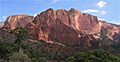
Beatty Point centered, from southwest. (Paria Point to left)
-
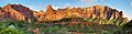
Kolob Canyons: Beatty Point (left), Nagunt Mesa (left of center), Timber Top Mountain (right)

