
Namur Historic District facts for kids
|
Namur Belgian-American District
|
|

Location in Wisconsin

Location in the United States
|
|
| Location | Namur, Wisconsin |
|---|---|
| Area | 3,500 acres (1,400 ha) |
| Architect | Varies |
| NRHP reference No. | 87002553 |
Quick facts for kids Significant dates |
|
| Added to NRHP | November 6, 1989 |
| Designated NHLD | December 14, 1990 |
The Namur Historic District, also called the Namur Belgian-American District, is a special area in Door County, Wisconsin. It is known as a historic district, which means it has important buildings and land that show how people lived in the past. This district includes the town of Namur and the countryside around it.
This area is very important because it has one of the largest collections of Belgian and Belgian-American culture in the United States. You can see their unique building styles and how they used the land. Because of its special history, it was named a National Historic Landmark in 1990.
The Story of Namur's Belgian Settlers
In the 1850s, the state of Wisconsin wanted more people to settle in its rural areas. Because of this, many immigrants from what is now Belgium started to arrive. These families came from provinces like Namur and Brabant.
They settled along the eastern shores of Brown, Kewaunee, and Door counties. They used local materials like red brick and limestone. They also used building methods from their homeland. This created a unique style of architecture.
In the 1860s and 1870s, Wisconsin had more Belgian-born residents than any other state. The area around Namur was chosen as the best example of this Belgian settlement.
What Makes the District Special?
The Namur Historic District is shaped like a rectangle. The village of Namur is just north of its southern edge. To the west and north, it is next to Green Bay and County Road "K". To the east, it is bordered by properties on Thruway Road.
This large district covers about 3,500 acres (1,400 ha). It has more than 180 buildings that are important to history. Most of these buildings are part of old farms. There are 41 separate farmsteads, and each one has more than five buildings on average. Most of these properties were built between 1880 and 1930.
Besides farms, the district also includes other important places. These include the St. Mary's Catholic Church and its parsonage house in Namur. There is also the Harold Euclide General Store, which was built in 1916.
Images for kids
-
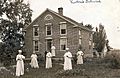
School run by the St. Norbert Abbey c. 1897; a marker honoring the location of this school at the historic district claims it as the birthplace of the Norbertine Fathers St. Norbert Abbey today is located in De Pere.

