Napoleon, Missouri facts for kids
Quick facts for kids
Napoleon, Missouri
|
|
|---|---|

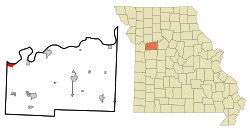
Location of Napoleon, Missouri
|
|
| Country | United States |
| State | Missouri |
| County | Lafayette |
| Area | |
| • Total | 1.75 sq mi (4.53 km2) |
| • Land | 1.75 sq mi (4.53 km2) |
| • Water | 0.00 sq mi (0.01 km2) |
| Elevation | 843 ft (257 m) |
| Population
(2020)
|
|
| • Total | 211 |
| • Density | 120.71/sq mi (46.61/km2) |
| Time zone | UTC-6 (Central (CST)) |
| • Summer (DST) | UTC-5 (CDT) |
| ZIP code |
64074
|
| Area code(s) | 816 |
| FIPS code | 29-51140 |
| GNIS feature ID | 2395149 |
Napoleon is a small city in Lafayette County, Missouri, in the United States. It's part of the larger Kansas City metropolitan area. This means it's close to the big city of Kansas City, Missouri, about 30 miles (48 km) to the east. In 2020, about 211 people lived here.
Contents
A Look Back in Time
The city of Napoleon was first planned out in 1836. It was most likely named after Napoleon Bonaparte, a famous French military leader. A post office has been serving the people of Napoleon since 1858.
Where is Napoleon?
Napoleon is located in the northwestern part of Lafayette County, Missouri. The United States Census Bureau says the city covers about 1.75 square miles (4.53 sq km) of land.
Interestingly, Napoleon is just a few miles west of another town called Wellington, Missouri. These two towns were named after the commanders who fought against each other at the famous Battle of Waterloo. Right between Napoleon and Wellington, you'll find a tiny place called "Waterloo."
The city is bordered on its north side by the Missouri River. To the south, you'll find U.S. Route 24 in Missouri, a major road. On the west, it borders Jackson County, Missouri. Napoleon is about 40 miles (64 km) east of the Kansas/Missouri state line. It's also about 6 miles (10 km) east of the city limits of Independence, Missouri. The town stretches about 2.5 miles (4 km) from east to west and about 1 mile (1.6 km) from north to south at its widest point.
Who Lives in Napoleon?
| Historical population | |||
|---|---|---|---|
| Census | Pop. | %± | |
| 1890 | 106 | — | |
| 1900 | 132 | 24.5% | |
| 1910 | 146 | 10.6% | |
| 1920 | 156 | 6.8% | |
| 1930 | 131 | −16.0% | |
| 1940 | 132 | 0.8% | |
| 1950 | 143 | 8.3% | |
| 1960 | 215 | 50.3% | |
| 1970 | 263 | 22.3% | |
| 1980 | 271 | 3.0% | |
| 1990 | 233 | −14.0% | |
| 2000 | 208 | −10.7% | |
| 2010 | 222 | 6.7% | |
| 2020 | 211 | −5.0% | |
| U.S. Decennial Census | |||
The number of people living in Napoleon has changed over the years. In 1890, there were 106 residents. The population grew to 222 by 2010, and then was 211 in 2020.
A Snapshot of the People
According to the census from 2010, 222 people lived in Napoleon. There were 85 households, and 69 of these were families. The city had about 127 people per square mile (49 per sq km).
Most of the people living in Napoleon were White (99.1%). A small number (0.9%) were from two or more racial backgrounds. About 0.5% of the population identified as Hispanic or Latino.
In terms of households, about 29.4% had children under 18 living there. Most households (65.9%) were married couples living together. Some households had a female head (11.8%) or a male head (3.5%) without a spouse. About 15.3% of all households were single individuals. About 5.9% of households had someone living alone who was 65 years old or older. On average, there were 2.61 people per household and 2.87 people per family.
The average age of people in the city was 43.8 years. About 21.6% of residents were under 18. About 9.1% were between 18 and 24. People aged 25 to 44 made up 21.3% of the population. Those aged 45 to 64 were 35.2%, and 13.1% were 65 years or older. The city had slightly more females (50.9%) than males (49.1%).
See also
 In Spanish: Napoleon (Misuri) para niños
 | Misty Copeland |
 | Raven Wilkinson |
 | Debra Austin |
 | Aesha Ash |

