Union Beach, New Jersey facts for kids
Quick facts for kids
Union Beach, New Jersey
|
||
|---|---|---|
|
Borough
|
||

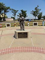
Fireman Memorial in Union Beach
|
||
|
||

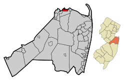
Location of Union Beach in Monmouth County highlighted in red (left). Inset map: Location of Monmouth County in New Jersey highlighted in orange (right).
|
||

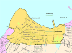
Census Bureau map of Union Beach, New Jersey
|
||
| Country | ||
| State | ||
| County | Monmouth | |
| Incorporated | April 16, 1925 | |
| Government | ||
| • Type | Borough | |
| • Body | Borough Council | |
| Area | ||
| • Total | 1.88 sq mi (4.87 km2) | |
| • Land | 1.78 sq mi (4.61 km2) | |
| • Water | 0.10 sq mi (0.26 km2) 5.32% | |
| Area rank | 421st of 565 in state 33rd of 53 in county |
|
| Elevation | 3 ft (0.9 m) | |
| Population
(2020)
|
||
| • Total | 5,723 | |
| • Estimate
(2023)
|
5,671 | |
| • Rank | 359th of 565 in state 31st of 53 in county |
|
| • Density | 3,211.6/sq mi (1,240.0/km2) | |
| • Density rank | 208th of 565 in state 23rd of 53 in county |
|
| Time zone | UTC−05:00 (Eastern (EST)) | |
| • Summer (DST) | UTC−04:00 (Eastern (EDT)) | |
| ZIP Code |
07735
|
|
| Area code(s) | 732 | |
| FIPS code | 3402574540 | |
| GNIS feature ID | 0885423 | |
Union Beach is a small town, called a borough, located on Raritan Bay in Monmouth County, New Jersey. It's part of the northern Jersey Shore. From its beach, you can even see the skyline of Manhattan in New York City far away!
Union Beach is a quiet place where many people live and travel to work in bigger cities. In 2020, about 5,723 people lived here.
The borough was officially created on March 16, 1925. Before that, it was part of Raritan Township. A vote was held on April 16, 1925, and people decided to form Union Beach. Long ago, a family named Poole owned a large farm here, going back to the American Revolutionary War. Later, in 1908, this farm became the Union Subdivision. An area once called East Point Beach Estates was renamed Union Beach in 1920 by a developer named Charles Carr.
Union Beach has worked with other towns in northern Monmouth County to make the area better. This plan, called the Bayshore Regional Strategic Plan, focused on improving downtown areas, keeping the history of the bay, and enjoying the natural beauty of the Raritan Bayshore coastline.
Contents
About Union Beach
Union Beach is about 16.1 miles from Staten Island's Outerbridge. The borough covers a total area of 1.88 square miles (4.87 km2). Most of this is land, about 1.78 square miles (4.61 km2), with a small part being water.
The beach in Union Beach has been greatly improved. It offers amazing views of the New York City skyline and the Verazanno Narrows Bridge. The U.S. Army Corps of Engineers helped with this big restoration project.
There is a special monument in Union Beach dedicated to the victims of the September 11 terrorist attacks. It was built in June 2002 from black stone. It's placed so that visitors can look past it towards where the World Trade Center towers once stood.
Within Union Beach, there are smaller areas and place names like Lorrillard Beach, Natco, Union Gardens, and Van Marters Corner. Union Beach shares borders with other towns in Monmouth County, including Hazlet, Keansburg (by water), and Keyport.
History of Union Beach
Facing Hurricane Sandy
On October 28, 2012, a very powerful storm called Hurricane Sandy was coming. The mayor of Union Beach asked everyone to leave the borough for safety. About one-third of the 6,200 residents left before the hurricane hit.
When Hurricane Sandy arrived, it caused a lot of damage. About 200 homes and businesses were harmed. Around 400 homes had more than 6 feet of water inside. Sadly, 62 homes were completely gone, and another 100 were moved off their foundations and could not be lived in anymore.
The borough's police department lost most of its cars to the flooding. Other towns, like Wilmington, NC and Clay County, Florida, helped by lending police cars. People who used to live in Union Beach also helped by sending supplies and advice. In total, Union Beach lost 14 police cars, three ambulances, and four fire trucks. Many towns donated vehicles to help Union Beach recover.
A popular restaurant and waterfront spot called Jakeabob's Bay was also destroyed by the hurricane. The storm surge washed through the building, taking everything with it. Even though the owner tried to rebuild, insurance problems prevented it from reopening permanently.
Union Beach Memorial School, the only school in the borough, was also flooded. Hundreds of library books, teaching materials, and musical instruments were ruined. But many volunteers, including students and teachers, worked hard to repair the school. They put in new floors, walls, desks, and even painted murals. The school was ready for students again before the end of that school year.
Education in Union Beach
Students in Union Beach attend schools in two different districts.
Union Beach School System
The Union Beach School System serves younger students from pre-kindergarten up to eighth grade. All these students go to Union Beach Memorial School. In the 2019–20 school year, there were about 640 students and 61.7 teachers, meaning about 10 students per teacher.
High School Options
For high school, students in ninth through twelfth grades attend Keyport High School in Keyport. This is part of a special agreement between the two school districts. In the 2019–20 school year, Keyport High School had about 373 students and 36.5 teachers.
Students also have other choices for high school. They can apply to Red Bank Regional High School if they are interested in its special programs. Another option is to apply to one of the career academies offered by the Monmouth County Vocational School District, which teach specific job skills.
Getting Around Union Beach
Roads and Highways
As of 2010, Union Beach had about 25.60 miles of roads. Most of these, 22.06 miles, are maintained by the borough itself. Monmouth County takes care of 2.93 miles, and the New Jersey Department of Transportation maintains 0.61 miles.
Route 36 is a main road that runs along the southern edge of Union Beach, next to Hazlet Township.
Public Transportation
NJ Transit offers local bus service on the 817 route, which goes to Perth Amboy. There are also direct bus services to New York City on the Academy bus route, called "Route 36 to Port Authority." Another Academy bus route, "Route 36 to Wall Street," also stops in town and goes directly to Wall Street in New York City.
If you prefer trains, the closest train station is in nearby Hazlet. This station is on the North Jersey Coastline service line.
Union Beach is also about 29 miles (33 minutes) from Newark Liberty International Airport in Newark / Elizabeth.
Boating
Union Beach is close to Staten Island, New York, by water. The distance across the water is about 2 to 3 nautical miles. This is roughly 2.3 to 3.5 miles in regular land measurements. The water route goes across the Raritan Bay, which is the body of water between Staten Island and the New Jersey coast.
Notable People
Some interesting people who have lived in or are connected to Union Beach include:
- Paul Bacon (born 1923), who designed many book and album covers.
- Skip O'Brien (1950–2011), an actor who had a regular role on the TV show CSI: Crime Scene Investigation.
See also
 In Spanish: Union Beach para niños


