
National Register of Historic Places listings in Curry County, Oregon facts for kids
The National Register of Historic Places (NRHP) is like a special list of places in the United States that are important because of their history, architecture, archaeology, engineering, or culture. When a place is on this list, it means it's recognized as a significant part of our country's story. In Curry County, Oregon, there are many amazing places on this list, from old lighthouses to historic buildings and even ancient archaeological sites. These places help us learn about the past and protect these important parts of history for future generations.
Contents
Historic Buildings and Structures
Curry County is home to several buildings and structures that tell tales of its past. These places show us how people lived, worked, and built things long ago.
Cape Blanco Lighthouse

The Cape Blanco Lighthouse is a famous landmark located on the westernmost part of Cape Blanco, near Sixes. It was first listed on the National Register of Historic Places in 1973. This beautiful lighthouse has guided ships along the Oregon coast for many years, standing strong against the ocean winds. It's a great example of how important lighthouses were for safe travel in the past.
Central Building in Brookings

In Brookings, you can find the Central Building at 703 Chetco Avenue. This building was constructed in 1915 by the C&O Lumber Company. It served as the main office for the Brookings Land & Townsite Company, which helped plan and build the mill town of Brookings. It's a key piece of the town's early history.
Gold Beach Ranger Station

The Gold Beach Ranger Station is located at 29279 Ellensburg Avenue in Gold Beach. Its unique "Cascadian Rustic" style buildings were built in 1936. What's really cool is that they were constructed by a crew from the Civilian Conservation Corps (CCC). The CCC was a program during the Great Depression that put young men to work on important public projects, like building parks and ranger stations.
Zane Grey Cabin

Near Galice, on the north bank of the Rogue River, is the Zane Grey Cabin. This log cabin was built in 1926 by Zane Grey, a very famous author known for his Western novels. He used this cabin as a quiet place to write and relax until 1935. It's a special spot for fans of American literature and the history of the American West.
Patrick Hughes House

The Patrick Hughes House is found within Cape Blanco State Park, near Sixes. This house was designed by P.J. Lindberg and built in 1898. It shows off a mix of architectural styles, including Queen Anne and Stick-Eastlake, which were popular at the time. It's a beautiful example of late 19th-century home design.
Peter John Lindberg House

In Port Orford, at 906 N. Washington Street, stands the Peter John Lindberg House. This house was added to the NRHP in 2015. It's another example of the historic architecture found in Curry County.
Port Orford Coast Guard Station
_(curDB4272).jpg)
The Port Orford Coast Guard Station is located at 92331 Coast Guard Hill Road in Port Orford. This station played an important role in maritime safety and rescue operations along the coast. It was listed in 1998, recognizing its historical significance to the region.
Isaac Lee Patterson Bridge
.jpg)
Also known as the Rogue River Bridge No. 01172, the Isaac Lee Patterson Bridge crosses the Rogue River in Gold Beach. This impressive bridge is part of US Highway 101 and was added to the NRHP in 2005. It's a vital link for transportation and a great example of bridge engineering from its time.
Rogue River Ranch

East of Agness, near where Mule Creek meets the Rogue River, is the Rogue River Ranch. This historic district was listed in 1975. Ranches like this were important for the development of the area, showing how people lived and worked off the land in earlier times.
Sixes Hotel

The Sixes Hotel is located at 93316 Sixes River Road in Sixes. This historic hotel was added to the NRHP in 1992. It's a reminder of the early days of travel and hospitality in the region, offering a glimpse into what life was like for travelers and locals.
Unique Historical Sites
Beyond buildings, Curry County has some truly unique sites that mark important moments in history.
Mary D. Hume Steamer

The Mary D. Hume was a steamer built in 1880 right in Gold Beach. This historic vessel, now wrecked at the Port of Gold Beach, was listed on the NRHP in 1979. It represents the important role of steamboats in transportation and trade along the coast and rivers of Oregon.
Wheeler Ridge Japanese Bombing Site
.jpg)
Deep within the Rogue River-Siskiyou National Forest near Brookings is the Wheeler Ridge Japanese Bombing Site. This site is incredibly significant because it marks the location of the first bombing in the United States by an airplane. This happened during World War II, making it a unique and important part of American history. It was listed in 2006.
Archaeological and Natural Sites
Many of Curry County's listings are archaeological sites or natural formations that hold clues about ancient cultures and the natural history of the area. These sites are often protected and not open to the public to preserve their historical value.
- 35-CU-215-High Point Shell Midden (Carpenterville)
- Arch Rock (Carpenterville)
- Archeological Site 35CU1 (Sixes)
- Archeological Site 35CU13 (Port Orford)
- Archeological Site 35CU14 (Port Orford)
- Archeological Site 35CU142 (Port Orford)
- Archeological Site 35CU153 (Port Orford)
- Archeological Site 35CU16 (Port Orford)
- Archeological Site 35CU31 (Pistol River)
- Archeological Site 35CU69 (Carpenterville)
- Archeological Site 35CU79 (Brookings)
- Archeological Site 35CU80 (Brookings)
- Archeological Site 35CU83 (Sixes)
- Blacklock Point Lithic Site (Port Orford)
- Blacklock Point Shell Midden (Port Orford)
- Cape Blanco Lithic Site (Port Orford)
- Eagle Rock (Pistol River)
- Harris Park Mound (Brookings)
- Indian Sands (Carpenterville)
- Indian Sands (Brookings)
- Khustenete-Hustenate-Xusteneten (Carpenterville)
- Little Ridge-Cape Sebastian (35CU77) (Pistol River)
- Little Ridge-Cape Sebastian (35CU78) (Pistol River)
- Lone Ranch Creek Mound (Brookings)
- Miller Creek (Carpenterville) (Also known as the Miller Shell Midden.)
- Newburgh Lithic Site (35CU209) (Sixes)
- Pistol River Site-Chetlessentan-Chetleshin-Chet-less-chun-dunn (Pistol River)
- Port Orford Site (Port Orford)
- Sheep Trail Shell Midden (35CU32) (Carpenterville)
- Thunder Rock (Carpenterville)
- Whale Head (Carpenterville)
- Whaleshead Lithic Site (35CU207) (Carpenterville)
- Whaleshead South Midden (35CU208) (Carpenterville)
- Whaleshead Trail Viewpoint (35CU36) (Carpenterville)
These sites, many of which are "Address Restricted" to protect them, include shell middens (ancient garbage dumps that tell us about diet and life), lithic sites (places where stone tools were made), and other archaeological areas. They provide valuable information about the early inhabitants of Curry County.
Former Listings
Sometimes, a place might be removed from the National Register of Historic Places. This can happen if it's no longer considered historically significant, or if it's been damaged or destroyed.
- Archeological Site 35CU156 (Port Orford) was listed in 1997 but was delisted on April 29, 2010.
Images for kids
-
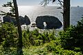
Arch Rock near Carpenterville.
-
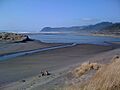
The mouth of the Pistol River.
-
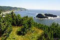
Whale Head near Carpenterville.
-
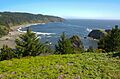
Whalehead Beach, near a historic viewpoint.


See also
- National Register of Historic Places listings in Oregon
- Listings in neighboring counties: Coos, Del Norte, Douglas, Josephine
- List of National Historic Landmarks in Oregon
- Historic preservation
- History of Oregon
- Lists of Oregon-related topics
External links
- Oregon Parks and Recreation Department, National Register Program
- National Park Service, National Register of Historic Places site
