| ` that are *not* used in the main body will be moved to a `==Images for kids==
* I will not change image filenames. 7. Word Count: Keep paragraphs short (max 5 lines) and sentences short (max 20 words). Aim for under 1500 words. This means being very selective about which entries to include. 8. Forbidden Syntax Check: Crucial step. I will review the entire output to ensure no Markdown, correct MediaWiki syntax for bold, italic, lists, links, images, and templates. No `
` at the end. No height/width changes in gallery.
9. Categories: Retain `` and ``. 10. Sensitive Topics: Ensure no sensitive topics are included. The current content is mostly historical buildings, so this should not be an issue.
Selection of entries to include (prioritizing those with images and some description):
- Charles Applegate House
- Baimbridge–Kanipe Farmstead Historic District
- Henry Brown House
- Will Q. Brown House and Wash House
- Canyonville Methodist Church
- China Ditch
- English Settlement School
- First Presbyterian Church of Roseburg
- Gardiner Historic District
- Glide Ranger Station
- Hershberger Mountain Lookout
- Howell–Kohlhagen House
- Kohlhagen Building
- Laurelwood Historic District
- Methodist Episcopal Church South (Roseburg)
- Mill–Pine Neighborhood Historic District (has a good description)
- Milo Academy Bridge
- Oakland Historic District
- Oregon State Soldier's Home Hospital
- Moses Parrott House
- Napoleon Rice House
- Roseburg Downtown Historic District
- Bernard Pitzer Smith House
- Henry Clay Smith House
- Stephens Community Historic District
- Tiller Ranger Station
- Umpqua River Bridge No. 01822
- Umpqua River Light House
- U.S. Coast Guard Station – Umpqua River, Administration and Equipment Buildings
- U.S. Post Office (Roseburg, Oregon)
- William C. and Agnes Winston House
- Judge William R. Willis House
- James Wimer Octagonal Barn
- Winchester Dam
- Roaring Camp Bridge (former listing)
- 35-DO-130-Tahkenitch Landing Site (archaeological)
- Veterans Affairs Roseburg Healthcare System Historic District
I will aim to give a short, engaging sentence or two for each, focusing on its type and location. I will not include all 50+ entries, but a good representative sample.
Let's start drafting.
```wikitext Douglas County, Oregon, is home to many special places that are listed on the National Register of Historic Places. This is like a national list of important buildings, sites, and objects that tell us about the history of the United States. When a place is on this list, it means it's recognized for its historical or architectural importance and helps us remember the past.
In Douglas County, these places include old houses, churches, bridges, and even entire neighborhoods! They show us how people lived, worked, and built communities long ago. Let's explore some of these amazing historical treasures.
Historic Homes and Buildings
Many homes in Douglas County have been preserved because they are important examples of how people lived in the past or because famous people lived there.
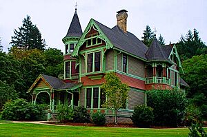
Charles Applegate House
The Charles Applegate House is located in Yoncalla. It was added to the National Register in 1975. Charles Applegate was an important pioneer in Oregon's history. This house helps us remember his life and the early days of settlement.
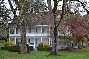
The historic Charles Applegate House in Yoncalla.
Henry Brown House
In Elkton, you can find the Henry Brown House. It was listed in 1979. This house is a great example of the kind of homes built in the late 1800s.
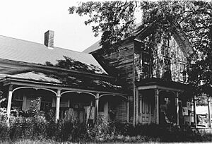
The Henry Brown House, a historic home in Elkton.
Will Q. Brown House and Wash House
The Will Q. Brown House and its separate wash house are in Riddle. This property was added to the list in 1987. It shows us how homes were set up in the past, often with separate buildings for tasks like laundry.
The Will Q. Brown House and Wash House in Riddle.
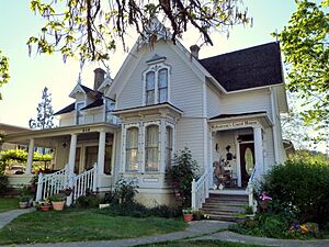
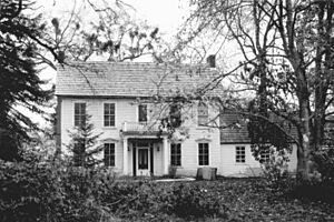
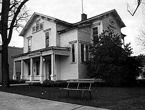
Nathaniel Curry House
The Nathaniel Curry House, located in Roseburg, became a historic site in 1983. It's another example of the beautiful architecture from earlier times in the area.
The Nathaniel Curry House in Roseburg.
Charles D. Drain Jr. House
In the town of Drain, there's the Charles D. Drain Jr. House, listed in 1978. This house is named after a key figure in the town's history.
The Charles D. Drain Jr. House in Drain.
Howell–Kohlhagen House
The Howell–Kohlhagen House in Roseburg was added to the Register in 1988. It's a significant building that tells part of Roseburg's story.
The Howell–Kohlhagen House in Roseburg.
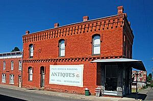
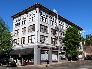
Kohlhagen Building
Also in Roseburg is the Kohlhagen Building, listed in 1997. This building likely played an important role in the town's business or community life.
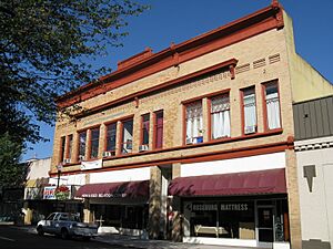
The Kohlhagen Building in Roseburg.
Moses Parrott House
The Moses Parrott House in Roseburg was recognized in 1980. It's another example of the historic homes that make up the character of the city.
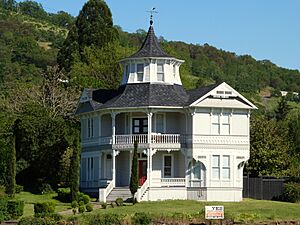
The Moses Parrott House in Roseburg.
Napoleon Rice House
The Napoleon Rice House, also in Roseburg, was listed in 1981. It's a reminder of the early residents and their contributions to the area.
The Napoleon Rice House in Roseburg.
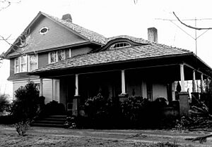
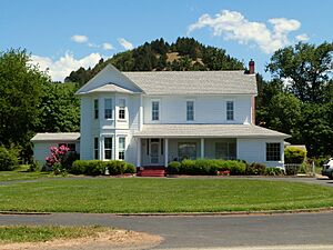
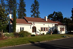
Bernard Pitzer Smith House
In Myrtle Creek, the Bernard Pitzer Smith House was added to the Register in 1988. This house helps us understand the history of homes in the Myrtle Creek area.
The Bernard Pitzer Smith House in Myrtle Creek.
Henry Clay Smith House
The Henry Clay Smith House in Winston was listed in 1997. It's a notable example of historic architecture in Winston.
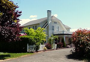
The Henry Clay Smith House in Winston.
William C. and Agnes Winston House
The William C. and Agnes Winston House, also in Winston, was recognized in 1987. This house is part of the rich history of the Winston community.
The William C. and Agnes Winston House in Winston.
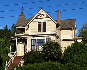
Judge William R. Willis House
The Judge William R. Willis House in Roseburg was listed in 1975. This house belonged to a judge, showing its connection to the legal history of the region.
The Judge William R. Willis House in Roseburg.
Historic Churches and Schools
Churches and schools are often central to a community's history, and Douglas County has several listed on the National Register.
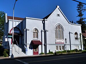
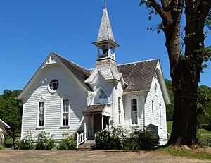
Canyonville Methodist Church
The Canyonville Methodist Church in Canyonville was listed in 1984. Churches often serve as important community gathering places for many years.
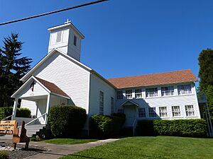
The Canyonville Methodist Church in Canyonville.
English Settlement School
The English Settlement School in Oakland was added to the Register in 2007. Old school buildings like this one remind us of how education used to be.
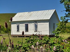
The English Settlement School in Oakland.
First Presbyterian Church of Roseburg
The First Presbyterian Church of Roseburg, located in Roseburg, was listed in 1988. It's a significant religious building in the city's history.
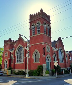
The First Presbyterian Church in Roseburg.
Methodist Episcopal Church South (Roseburg)
Another historic church in Roseburg is the Methodist Episcopal Church South, listed in 1985. These churches show the growth of different religious communities in the area.
The Methodist Episcopal Church South in Roseburg.
Bridges and Other Structures
Douglas County also has historic bridges and other unique structures that are important to its past.
China Ditch
The China Ditch, located near Myrtle Creek, was listed in 1991. This ditch is an old water system, likely built for mining or irrigation, and represents an important part of the region's development.
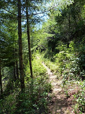
A section of the historic China Ditch.
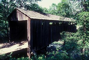
Milo Academy Bridge
The Milo Academy Bridge, southeast of Days Creek, was added to the Register in 1979. Historic bridges are often admired for their engineering and design.
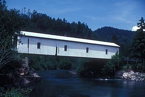
The Milo Academy Bridge near Days Creek.
Umpqua River Bridge No. 01822
The Umpqua River Bridge No. 01822, located in Reedsport, was listed in 2005. This bridge helps connect communities and is a vital part of the transportation history of the region.
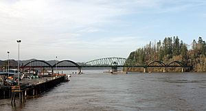
The Umpqua River Bridge in Reedsport.
Umpqua River Light House
The Umpqua River Light House, southwest of Winchester Bay, was recognized in 1977. Lighthouses are important historical structures that guided ships and helped keep people safe.
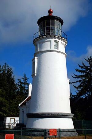
The Umpqua River Light House.
Winchester Dam
The Winchester Dam, on the North Umpqua River at Winchester, was listed in 1996. Dams are important for managing water resources and generating power, and this one has historical significance.
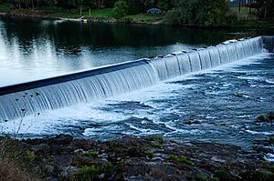
The Winchester Dam on the North Umpqua River.
James Wimer Octagonal Barn
The James Wimer Octagonal Barn in Lookingglass was added to the Register in 1985. Octagonal barns are unique and interesting structures, different from typical rectangular barns.
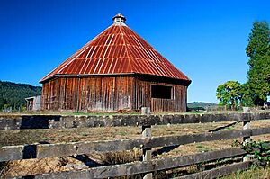
The James Wimer Octagonal Barn.
Historic Districts
Sometimes, it's not just one building but a whole area that is historically important. These are called historic districts.
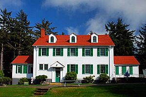
Baimbridge–Kanipe Farmstead Historic District
The Baimbridge–Kanipe Farmstead Historic District in Oakland was listed in 2008. This district includes a farm and its surrounding land, showing how farming communities were set up.
A view of the Baimbridge–Kanipe Farmstead Historic District.
Gardiner Historic District
The Gardiner Historic District in Gardiner was recognized in 1994. This district includes many buildings that together tell the story of the town's development.
Buildings in the Gardiner Historic District.
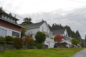
Laurelwood Historic District
The Laurelwood Historic District in Roseburg was listed in 1990. This area has many historic homes that give us a glimpse into Roseburg's past neighborhoods.
A residence in the Laurelwood Historic District.
Mill–Pine Neighborhood Historic District
The Mill–Pine Neighborhood Historic District in Roseburg was added in 1985. This neighborhood developed starting in 1878 to house workers for the railroad and other local businesses. It's a great example of a working-class neighborhood from the late 1800s and early 1900s.
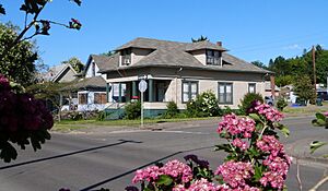
A house in the Mill–Pine Neighborhood Historic District.
Oakland Historic District
The Oakland Historic District in Oakland was listed in 1979. This district preserves the historic center of Oakland, showing its early architecture and town planning.
A building in the Oakland Historic District.
Roseburg Downtown Historic District
The Roseburg Downtown Historic District was recognized in 2003. This area includes many important buildings in the heart of Roseburg, showing its commercial and civic history.
The Masonic Temple in the Roseburg Downtown Historic District.
The Stephens Community Historic District in Sutherlin was listed in 1984. This district helps preserve the history of the Stephens community.
A church in the Stephens Community Historic District.
Tiller Ranger Station
The Tiller Ranger Station in Tiller was added to the Register in 1991. Ranger stations are important for the history of forest management and conservation.
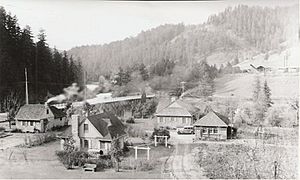
The Tiller Ranger Station in 1941.
Veterans Affairs Roseburg Healthcare System Historic District
This district in Roseburg was listed in 2013. It includes buildings that were part of a hospital for veterans, showing the history of healthcare and support for soldiers.

A building at the Veterans Affairs Roseburg Healthcare System.
Other Interesting Sites
Some sites are important for their archaeological value or unique purpose.
35-DO-130-Tahkenitch Landing Site
This site near Gardiner was listed in 2003. It's an archaeological site, meaning it holds clues about ancient human activity in the area.
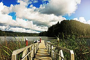
A boat dock on Lake Tahkenitch, near the landing site.
Glide Ranger Station
The Glide Ranger Station in Glide was listed in 1986. Like the Tiller Ranger Station, it's part of the history of forest service in Oregon.
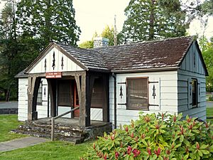
The Glide Ranger Station.
Hershberger Mountain Lookout
The Hershberger Mountain Lookout, near Prospect, was added in 2000. Fire lookouts were crucial for spotting forest fires and protecting natural resources.
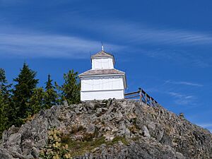
The Hershberger Mountain Lookout.
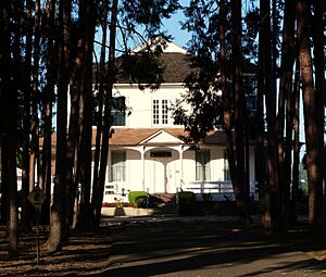
Oregon State Soldier's Home Hospital
This hospital in Roseburg was listed in 2012. It served as a home and hospital for soldiers, showing the care provided to veterans.
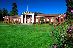
The Umpqua Arts Center, which was formerly the Oregon State Soldier's Home Hospital.
U.S. Coast Guard Station – Umpqua River, Administration and Equipment Buildings
These buildings in Winchester Bay were listed in 1992. They represent the history of the U.S. Coast Guard's work in protecting the coast and helping sailors.
The Umpqua River Lighthouse Museum, part of the Coast Guard Station area.
U.S. Post Office (Roseburg, Oregon)
The U.S. Post Office in Roseburg was recognized in 1979. Post offices are important historical buildings because they were central to communication and community life.
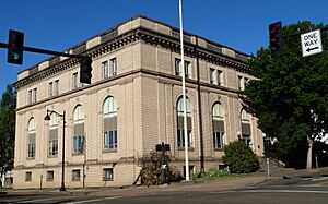
The old U.S. Post Office in Roseburg.
Former Listings
Sometimes, a place might be removed from the National Register, often because it has been changed or destroyed.
Roaring Camp Bridge
The Roaring Camp Bridge, west of Drain, was listed in 1979 but later removed in 1996. This means it was once considered historically important but is no longer on the list.
The Roaring Camp Bridge before it was delisted.
These historic places in Douglas County help us learn about the past and appreciate the rich history of Oregon!
See also
External links
- Oregon Parks and Recreation Department, National Register Program
- National Park Service, National Register of Historic Places site
-
```
|


.jpg)


_(douDA0102).jpg)


_(douDA0211).jpg)
_(douDA0067a).jpg)
_(douDA0077a).jpg)
_(douDA0045).jpg)
.jpg)


_(douDA0061).jpg)


_(douDA0027).jpg)
_(douDA0216).jpg)


