Sutherlin, Oregon facts for kids
Quick facts for kids
Sutherlin, Oregon
|
|
|---|---|

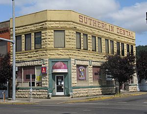
The historic Sutherlin Bank Building (built 1910), located at 101 West Central Avenue in Sutherlin
|
|
| Nickname(s):
City of Flags
|
|

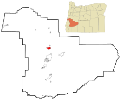
Location in Oregon
|
|
| Country | United States |
| State | Oregon |
| County | Douglas |
| Incorporated | 1911 |
| Area | |
| • Total | 6.19 sq mi (16.04 km2) |
| • Land | 6.11 sq mi (15.83 km2) |
| • Water | 0.08 sq mi (0.21 km2) |
| Elevation | 525 ft (160 m) |
| Population
(2020)
|
|
| • Total | 8,524 |
| • Density | 1,394.86/sq mi (538.53/km2) |
| Time zone | UTC-8 (Pacific) |
| • Summer (DST) | UTC-7 (Pacific) |
| ZIP code |
97479
|
| Area code(s) | 541 |
| FIPS code | 41-71650 |
| GNIS feature ID | 2412018 |
| Website | www.ci.sutherlin.or.us |
Sutherlin is a city in Douglas County, Oregon, United States. In 2010, about 7,810 people lived there. This made it the second largest city in Douglas County at that time.
Sutherlin is located right off Interstate 5, a big highway. Nearby, you can find places like Cooper Creek Reservoir and the Umpqua River. There is also a golf course and many vineyards, which are farms where grapes are grown.
The Sutherlin Police Department also helps keep the peace in the nearby city of Oakland. They do this through a special agreement.
Contents
Geography and Climate in Sutherlin
Sutherlin is located at 43°23′18″N 123°18′58″W / 43.38833°N 123.31611°W.
Land and Water Areas
The United States Census Bureau says the city covers about 6.35 square miles (16.45 square kilometers). Most of this area, about 6.15 square miles (15.93 square kilometers), is land. The rest, about 0.20 square miles (0.52 square kilometers), is water.
Sutherlin's Weather
Sutherlin has a typical western Oregon Mediterranean climate. This means it has dry summers with cool mornings and hot afternoons. Winters are chilly and wet.
| Climate data for Sutherlin, OR | |||||||||||||
|---|---|---|---|---|---|---|---|---|---|---|---|---|---|
| Month | Jan | Feb | Mar | Apr | May | Jun | Jul | Aug | Sep | Oct | Nov | Dec | Year |
| Mean daily maximum °F (°C) | 49 (9) |
53 (12) |
58 (14) |
62 (17) |
69 (21) |
75 (24) |
83 (28) |
84 (29) |
78 (26) |
67 (19) |
53 (12) |
47 (8) |
65 (18) |
| Mean daily minimum °F (°C) | 36 (2) |
36 (2) |
38 (3) |
41 (5) |
46 (8) |
51 (11) |
55 (13) |
54 (12) |
49 (9) |
43 (6) |
40 (4) |
36 (2) |
44 (6) |
| Average precipitation inches (mm) | 5.57 (141) |
4.39 (112) |
4.20 (107) |
3.25 (83) |
2.28 (58) |
1.21 (31) |
0.40 (10) |
0.49 (12) |
1.20 (30) |
2.92 (74) |
6.01 (153) |
6.80 (173) |
38.72 (984) |
Population of Sutherlin
| Historical population | |||
|---|---|---|---|
| Census | Pop. | %± | |
| 1920 | 515 | — | |
| 1930 | 457 | −11.3% | |
| 1940 | 525 | 14.9% | |
| 1950 | 2,230 | 324.8% | |
| 1960 | 2,452 | 10.0% | |
| 1970 | 3,070 | 25.2% | |
| 1980 | 4,560 | 48.5% | |
| 1990 | 5,020 | 10.1% | |
| 2000 | 6,668 | 32.8% | |
| 2010 | 7,810 | 17.1% | |
| 2020 | 8,524 | 9.1% | |
| 2021 (est.) | 8,593 | 10.0% | |
| U.S. Decennial Census | |||
People Living in Sutherlin (2010)
In 2010, a census counted 7,810 people living in Sutherlin. There were 3,249 homes, and 2,178 of these were families.
Most people living in Sutherlin were White (92.4%). There were also Native American (1.9%), Asian (0.6%), and African American (0.2%) residents. About 6.1% of the population was Hispanic or Latino.
Out of all the homes, 27.3% had children under 18 living there. About 51.6% of homes were married couples. Also, 27.3% of homes had only one person living there.
The average age of people in Sutherlin was 44.8 years old. About 22.4% of residents were under 18. And 24% of residents were 65 years old or older. The city had slightly more females (52.4%) than males (47.6%).
See also
 In Spanish: Sutherlin para niños
 | Victor J. Glover |
 | Yvonne Cagle |
 | Jeanette Epps |
 | Bernard A. Harris Jr. |


