
National Register of Historic Places listings in Harrison County, Mississippi facts for kids

Did you know that many special places in Harrison County, Mississippi, are protected because of their history? These places are listed on the National Register of Historic Places. It's like a special list kept by the United States government. When a building, site, or even a whole neighborhood is on this list, it means it's important to our country's past.
Harrison County has 53 places on this list right now. One of them is even more special and is called a National Historic Landmark. Sadly, 14 other places used to be on the list but were removed, often because they were damaged or destroyed, especially by big storms like Hurricane Katrina.
What is the National Register of Historic Places?
The National Register of Historic Places is the official list of buildings, districts, places, structures, and objects that are important in American history, architecture, archaeology, engineering, and culture. It's managed by the National Park Service. Being on the list helps protect these places and often makes them eligible for special grants or tax breaks for their upkeep.
Historic Places You Can Visit in Harrison County
Many of the places on the National Register in Harrison County are private homes or areas, but some are public and you can visit them!
Beauvoir: Home of a President
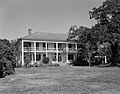
One of the most famous places is Beauvoir in Biloxi. This beautiful home was where Jefferson Davis, who was the president of the Confederate States of America during the American Civil War, lived after the war. It was built in 1852. Beauvoir was badly damaged by Hurricane Katrina in 2005, but it has been carefully restored and is now a museum that you can visit. It's a National Historic Landmark, which means it's considered one of the most important historic places in the entire country.
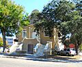
Biloxi Lighthouse: A Guiding Light
The Biloxi Lighthouse is a famous landmark on U.S. Route 90 in Biloxi. It was built in 1848 and was one of the first cast-iron lighthouses in the South. For many years, it was even run by women keepers! Like Beauvoir, it was heavily damaged by Hurricane Katrina but was fully repaired and reopened in 2010. It's a great place to learn about the history of the coast and how lighthouses work.
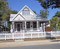
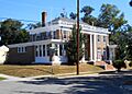
Old Brick House: A Community Hub
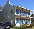
The Old Brick House in Biloxi, also known as the Biloxi Garden Center, was built in 1850. It's one of the oldest surviving buildings in Biloxi. After Hurricane Katrina, it was also restored and is now used as a museum and a place for community events. Imagine the stories these old bricks could tell!
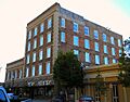
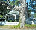
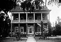
Magnolia Hotel: A Glimpse into the Past
The Magnolia Hotel in Biloxi was built way back in 1847. It's one of the oldest hotels on the Mississippi Gulf Coast. Today, it's no longer a hotel but a museum, giving visitors a peek into what life was like long ago.
Fort Massachusetts: A Civil War Fortress
Off the coast of Gulfport, on Ship Island, you'll find Fort Massachusetts. This fort was built between 1859 and 1866 to help defend the country. It played a role during the Civil War. Today, it's part of the Gulf Islands National Seashore and is a popular spot for tourists to explore and learn about military history.
Gulfport Army Air Field Hangar: Aviation History
The Gulfport Army Air Field Hangar was built in 1944-1945 during World War II. It was used to train flight crews to operate the huge Boeing B-29 Superfortress airplanes. After the war, from 1947 to 1963, it even served as the passenger terminal for the Gulfport-Biloxi International Airport. It's a cool piece of aviation history!
Saenger Theater: A Place for Shows
The Saenger Theater in Biloxi was built in 1928-1929. It's a beautiful old theater that still hosts performing arts events today. Imagine all the shows and movies that have been seen there over the decades!
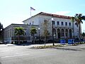
U.S. Post Office, Courthouse, and Customhouse (Biloxi)
This grand building in Biloxi, built between 1905 and 1908, used to be the U.S. Post Office, Courthouse, and Customhouse. It's built in a style called Neoclassical architecture, which looks a bit like ancient Greek or Roman buildings. Today, it serves as the Biloxi City Hall.
Historic Districts: Whole Neighborhoods with History
Some listings on the National Register aren't just single buildings, but entire areas called "historic districts." These districts have many buildings that together tell a story about the past.
- Biloxi Downtown Historic District: This area includes many historic buildings along Howard Avenue and nearby streets in downtown Biloxi.
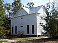
- Cuevas Rural Historic District: Located in Pass Christian, this district includes the Pineville Presbyterian Church, built in 1917, and other historic rural buildings.
- Scenic Drive Historic District: In Pass Christian, this beautiful drive was once lined with many historic properties. Sadly, many were destroyed by Hurricane Katrina, but the area remains important.
- Turkey Creek Community Historic District: This district in Gulfport is special because it's an African American settlement that dates back to around 1870. It shows the history of this community.
Places Affected by Hurricane Katrina
Hurricane Katrina, a massive storm in 2005, caused huge damage along the Mississippi Gulf Coast. Many historic places in Harrison County were destroyed or so badly damaged that they had to be taken off the National Register.
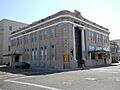
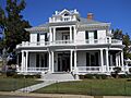
For example, the Tivoli Hotel in Biloxi, built around 1926, was demolished after the hurricane. The Church of the Redeemer, built in 1874, was also destroyed. Even though it had been rebuilt after Hurricane Camille in 1969, Katrina was too powerful. Many historic homes, like the Bailey House, Brielmaier House, Gillis House, Hermann House, and Milner House (also known as Grass Lawn), were also lost.
These losses remind us how important it is to protect our historic places, as they can be vulnerable to natural disasters.
Current listings
| Name on the Register | Image | Date listed | Location | City or town | Description | |
|---|---|---|---|---|---|---|
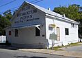
| 1 | E. Barq Pop Factory |
 |
(#84002164) |
140 Keller Avenue 30°23′45″N 88°52′41″W / 30.39595°N 88.878131°W |
Biloxi | Barq's root beer was created by Edward C. Barq in 1898 and was produced on this site until 1936. |
| 2 | Raymond Bass Site (22HR636) |
(#87000230) |
Address Restricted |
Biloxi | Domestic camp site, 1499-1000 AD | |
| 3 | Beauvoir |
 |
(#71000448) |
200 West Beach Boulevard 30°23′40″N 88°58′12″W / 30.394444°N 88.97°W |
Biloxi | Post-war home of Confederate President Jefferson Davis. Badly damaged by Hurricane Katrina, but restored. |
| 4 | Thomas and Melinda Benton House |
 |
(#02000857) |
14115 Rippy Road 30°25′28″N 89°04′22″W / 30.424436°N 89.072647°W |
Gulfport | Constructed circa 1870, private ownership |
| 5 | Biloxi Downtown Historic District |
.jpg) |
(#98001139) |
Roughly along Howard Avenue, from Reynoir Street to Lameuse Street; also Roughly bounded by Rue Magnolia, Howard Ave., Main & Water Sts. 30°23′47″N 88°53′19″W / 30.396389°N 88.888611°W |
Biloxi | View northwest from intersection of Howard Avenue and Lameuse Street, Biloxi; second set of address represents a boundary increase 2015-01-13 |
| 6 | Biloxi Garden Center |
 |
(#73001011) |
410 East Bayview Avenue 30°24′43″N 88°52′58″W / 30.411944°N 88.882778°W |
Biloxi | Also known as Old Brick House. Badly damaged by Hurricane Katrina, but restored and rededicated in 2011. Now used as a museum and venue for community events. |
| 7 | Biloxi Lighthouse |
 |
(#73001012) |
On U.S. Route 90 at Porter Avenue 30°23′39″N 88°54′04″W / 30.394167°N 88.901111°W |
Biloxi | Badly damaged by Hurricane Katrina but fully restored and reopened in 2010. |
| 8 | Biloxi Veterans Administration Medical Center |
 |
(#02000045) |
400 Veterans Avenue 30°24′56″N 88°56′35″W / 30.415494°N 88.943011°W |
Biloxi | Constructed 1932-33 |
| 9 | Bond-Grant House |
 |
(#84002169) |
932 West Howard Avenue 30°23′51″N 88°53′39″W / 30.397619°N 88.89415°W |
Biloxi | Serves as Biloxi Visitor's Center |
| 10 | Broadmoor Place Historic District |
(#15000665) |
Roughly bounded by Pine & Cypress Aves., 25th & 22nd Sts. 30°22′45″N 89°04′16″W / 30.3792°N 89.0711°W |
Gulfport | ||
| 11 | Brunet-Fourchy House |
 |
(#84002173) |
138 Magnolia Street Mall 30°23′39″N 88°53′18″W / 30.394167°N 88.888333°W |
Biloxi | Constructed circa 1835, adapted as restaurant 1964 |
| 12 | Central Gulfport Historic District |
(#15000986) |
Roughly bounded by 24th & 17th Sts., 18th & 23rd Aves. 30°22′32″N 89°05′15″W / 30.375460°N 89.087370°W |
Gulfport | ||
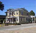
| 13 | Clemens House |
 |
(#84002180) |
764 Water Street 30°23′42″N 88°53′16″W / 30.394906°N 88.887781°W |
Biloxi | Constructed as residence circa 1850. Commercial business location 2011. |
| 14 | Cuevas Rural Historic District |
.jpg) |
(#10000902) |
Menge Avenue running north-south between Red Creek Road and Fahrion Drive 30°21′20″N 89°13′03″W / 30.355556°N 89.2175°W |
Pass Christian | Constructed in 1917, the Pineville Presbyterian Church is part of the Cuevas Rural Historic District |
| 15 | G.B. Dantzler House |
 |
(#89002051) |
1238 East Beach Boulevard 30°22′19″N 89°04′24″W / 30.371944°N 89.073333°W |
Gulfport | Constructed 1924 in Spanish architectural style, private residence |
| 16 | East Howard Avenue Historic District |
(#15000297) |
Roughly bounded by Dukate, Nixon, Jefferson & Holley Sts., Peyton Dr. & Comfort Pl. 30°23′47″N 88°52′47″W / 30.3964°N 88.8796°W |
Biloxi | ||
| 17 | Fort Massachusetts |
 |
(#71000067) |
South of Gulfport on Ship Island, in Gulf Islands National Seashore 30°12′36″N 88°58′23″W / 30.21°N 88.973056°W |
Gulfport | Constructed 1859-1866 for national defense. Gulf Islands National Seashore tourist attraction. |
| 18 | French Warehouse Site |
 |
(#91001768) |
Gulf Islands National Seashore 30°14′11″N 88°53′23″W / 30.236389°N 88.889722°W |
Ocean Springs | Remnants of warehouse complex established on Ship Island circa 1717. |
| 19 | Gulf Coast Center for the Arts |
 |
(#84002187) |
124 Lameuse Street 30°23′40″N 88°53′13″W / 30.394506°N 88.887025°W |
Biloxi | Also known as old Biloxi Public Library. |
| 20 | Gulf Gardens Historic District |
(#16000615) |
Roughly bounded by 34th Ave., Terrace Dr., 18th & 15th Sts. 30°22′16″N 89°06′18″W / 30.371197°N 89.105044°W |
Gulfport | ||
| 21 | Gulfport Army Air Field Hangar |
 |
(#11000111) |
4455 Hewes Avenue 30°24′18″N 89°03′47″W / 30.405131°N 89.062953°W |
Gulfport | Built in 1944-45, the hangar was used to train combat crews to operate the B-29 Superfortress. From 1947-63, it was the passenger terminal for the Gulfport Municipal Airport. |
| 22 | Gulfport Harbor Square Commercial Historic District |
 |
(#11000762) |
Roughly between 23rd & 28th Aves., 13th St. & 25th Ave. to junction with 17th St. 30°22′10″N 89°05′34″W / 30.369444°N 89.092778°W |
Gulfport | Historic commercial area for the City of Gulfport |
| 23 | Gulfport Veterans Administration Medical Center Historic District |
.jpg) |
(#13001080) |
200 Beach Blvd. 30°22′41″N 89°03′08″W / 30.378105°N 89.052356°W |
Gulfport | Constructed 1920-1950; served as Veterans Administration Medical Center until Hurricane Katrina resulted in its closure in 2005 |
| 24 | Gunston Hall |
 |
(#14000564) |
1694 Beach Blvd. 30°23′38″N 88°56′18″W / 30.3939°N 88.9383°W |
Biloxi | Completed in 1905 as a home. Became White Pillars Restaurant, 1970-89. |
| 25 | Hewes Building |
 |
(#82000575) |
2505 14th Street 30°22′04″N 89°05′36″W / 30.367911°N 89.093322°W |
Gulfport | Constructed 1903-04 in Italian Renaissance architectural style. Commercial business location. |
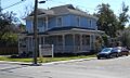
| 26 | House at 638 East Howard Avenue |
 |
(#86001673) |
638 East Howard Avenue 30°23′46″N 88°53′00″W / 30.396197°N 88.883211°W |
Biloxi | Constructed as residence circa 1900. Commercial business location 2011. |
| 27 | JOSEPHINE (Shipwreck) |
(#00001402) |
Address Restricted |
Biloxi | A sidewheel steamer built in 1867, foundered in a storm in 1881. | |
| 28 | Lameuse Street Historic District |
(#15000301) |
Roughly 200-300 blocks Lameuse St., 300 block Haise St. and 300 block of Main St. 30°24′11″N 88°53′14″W / 30.4031°N 88.8872°W |
Biloxi | ||
| 29 | Magnolia Hotel |
.jpg) |
(#73001013) |
137 Rue Magnolia 30°23′41″N 88°53′22″W / 30.394664°N 88.889342°W |
Biloxi | Constructed in 1847, now a museum |
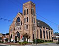
| 30 | Nativity BVM Cathedral |
 |
(#84002193) |
870 West Howard Avenue 30°23′49″N 88°53′28″W / 30.396944°N 88.891111°W |
Biloxi | Cathedral of the Nativity of the Blessed Virgin Mary (Catholic), constructed in 1902 |
| 31 | Peoples Bank of Biloxi |
.jpg) |
(#84002195) |
152 Lameuse Street 30°23′46″N 88°53′13″W / 30.396158°N 88.886919°W |
Biloxi | Constructed in 1914 |
| 32 | W.J. Quarles House and Cottage |
 |
(#80002244) |
181 East Old Pass Road 30°21′09″N 89°09′07″W / 30.352478°N 89.151975°W |
Long Beach | Constructed circa 1892. Quarles House was moved from original location, undergoing restoration 2013. |
| 33 | Redding House |
 |
(#84002197) |
770 Jackson Street 30°23′44″N 88°53′16″W / 30.395556°N 88.887778°W |
Biloxi | Constructed in 1908, serves as venue for receptions and public gatherings |
| 34 | Reynoir Street Historic District |
(#14001153) |
200 blk. Reynoir St. 30°24′03″N 88°53′25″W / 30.4008°N 88.8903°W |
Biloxi | ||
| 35 | Saenger Theater |
 |
(#84002200) |
170 Reynoir Street 30°23′50″N 88°53′24″W / 30.397244°N 88.890103°W |
Biloxi | Constructed 1928-28, serves as venue for performing arts |
| 36 | Scenic Drive Historic District |
 |
(#79001309) |
Scenic Drive 30°19′04″N 89°14′28″W / 30.317778°N 89.241111°W |
Pass Christian | Out of 135 historic properties along Pass Christian's Scenic Drive Historic District, 70 were destroyed by, or subsequently demolished because of Hurricane Katrina |
| 37 | Scherer House |
 |
(#84002201) |
782 Water Street 30°23′41″N 88°53′18″W / 30.394819°N 88.888406°W |
Biloxi | Also known as Spanish House. Constructed circa 1846, used as commercial business in 2011 |
| 38 | Seashore Campground School |
.jpg) |
(#84002204) |
1410 Leggett Drive 30°23′44″N 88°55′12″W / 30.395556°N 88.92°W |
Biloxi | Church School constructed in 1915 |
| 39 | Second Street Historic District |
(#15000987) |
Along 2nd St. 30°21′04″N 89°08′44″W / 30.351159°N 89.145648°W |
Gulfport | ||
| 40 | Soria City Historic District |
(#15000666) |
Roughly bounded by 17th & Bullis Aves., 21st, 22nd & 20th Sts. 30°22′35″N 89°04′43″W / 30.3763°N 89.0787°W |
Gulfport | ||
| 41 | Southwest Gulfport Historic District |
(#16000281) |
Bounded by Railroad, 15th, 11th, 9th & Central Sts., 32nd, 36th, 37th, 42nd, 43rd & 34th Aves. 30°21′52″N 89°06′29″W / 30.364445°N 89.108167°W |
Gulfport | ||
| 42 | Suter House |
 |
(#84002205) |
1012 Tullier Court 30°23′50″N 88°53′56″W / 30.397222°N 88.898889°W |
Biloxi | Constructed circa 1885, private residence |
| 43 | Glenn Swetman House |
 |
(#84002206) |
1596 Glenn Swetman Street 30°23′43″N 88°55′57″W / 30.395278°N 88.9325°W |
Biloxi | Constructed in 1926, private residence |
| 44 | Turkey Creek Community Historic District |
 |
(#07000173) |
Rippy Road and environs 30°25′25″N 89°04′37″W / 30.423589°N 89.076917°W |
Gulfport | Turkey Creek Community is an African American settlement dating from circa 1870. |
| 45 | U.S. Post Office, Courthouse, and Customhouse |
 |
(#78001600) |
140 Lameuse Street 30°23′43″N 88°53′13″W / 30.395397°N 88.886919°W |
Biloxi | Also known as Biloxi City Hall. Constructed 1905-08 in Neoclassical Architectural Style. Location of Biloxi City Hall. |
| 46 | US Post Office and Customhouse |
 |
(#84002209) |
2421 13th Street 30°22′00″N 89°05′33″W / 30.366667°N 89.0925°W |
Gulfport | Building offered for sale in 2010 |
| 47 | Upper West Central Historic District |
(#15000302) |
Roughly bounded by Hopkins Blvd., CSXRR, Iroquois, Esposito & Division Sts. 30°24′01″N 88°53′48″W / 30.4004°N 88.8967°W |
Biloxi | Boundary alterations (increases and decreases) listed on June 4, 2015 | |
| 48 | H.S. and Mattie M. Walker House |
 |
(#14000565) |
1114 32nd Ave. 30°21′56″N 89°06′01″W / 30.3655°N 89.1002°W |
Gulfport | |
| 49 | West Beach Historic District |
 |
(#84002210) |
Roughly U.S. Route 90 between Rosell and Chalmers Avenue 30°23′46″N 88°54′38″W / 30.396111°N 88.910556°W |
Biloxi | View is within Old Biloxi Cemetery |
| 50 | West Central Historic District |
 |
(#84002212) |
Roughly bounded by U.S. Route 90, Hopkins Boulevard, and Howard and Benachi Avenues 30°23′45″N 88°53′53″W / 30.395833°N 88.898056°W |
Biloxi | Historic structure (house) at intersection of Seal Avenue and West Howard Avenue |
Former listings
| Name on the Register | Image | Date listed | Date removed | Location | City or town | Summary | |
|---|---|---|---|---|---|---|---|
| 1 | Bailey House |
(#84002160) |
|
1333 East Beach Boulevard 30°23′41″N 88°54′58″W / 30.394722°N 88.916111°W |
Biloxi | Constructed circa 1850. Destroyed by Hurricane Katrina August 29, 2005. | |
| 2 | Biloxi's Tivoli Hotel |
 |
(#84002167) |
|
420 Beach Boulevard 30°23′38″N 88°52′26″W / 30.3939°N 88.8739°W |
Biloxi | Constructed circa 1926, demolished May 2006 after damage by Hurricane Katrina. |
| 3 | Brielmaier House |
(#84002170) |
|
710 Beach Boulevard 30°23′36″N 88°53′10″W / 30.393381°N 88.8861°W |
Biloxi | Constructed circa 1895. Was delisted in 1986 after the house was moved from its original location, and was readded to the Register in 1995. Destroyed by Hurricane Katrina August 29, 2005. | |
| 4 | Church of the Redeemer |
 |
(#84002177) |
|
Bellman Street 30°23′48″N 88°52′54″W / 30.3967°N 88.8817°W |
Biloxi | Constructed circa 1874. Heavily damaged by Hurricane Camille on August 17, 1969 but rebuilt. Destroyed by Hurricane Katrina August 29, 2005 and demolished. The Hurricane Camille Memorial that was dedicated on October 2, 2007 remains on the site. |
| 5 | Fisherman's Cottage |
(#84002182) |
|
138 Lameuse Street |
Biloxi | Destroyed by Hurricane Katrina August 29, 2005. | |
| 6 | Gillis House |
.jpg) |
(#78001599) |
|
513 East Beach Boulevard |
Biloxi | Originally Listed in 1973. Removed from register in 1977, restored in 1978. Destroyed by Hurricane Katrina August 29, 2005. |
| 7 | Harbor Square Historic District |
 |
(#85001788) |
|
Roughly bounded by the former Louisville and Nashville railroad line, 23rd Avenue, 13th Street and 27th Avenue 30°22′05″N 89°05′35″W / 30.3681°N 89.0931°W |
Gulfport | Listing replaced by Gulfport Harbor Square Commercial Historic District |
| 8 | Hermann House |
.jpg) |
(#84002189) |
|
523 East Beach Boulevard 30°23′35″N 88°52′23″W / 30.3931°N 88.8731°W |
Biloxi | Constructed circa 1850. Destroyed by Hurricane Katrina August 29, 2005. |
| 9 | Finley B. Hewes House |
(#78001599) |
|
604 East Beach Boulevard |
Gulfport | Destroyed by Hurricane Katrina August 29, 2005. | |
| 10 | House at 771 Water Street |
(#84002191) |
|
771 Water Street |
Biloxi | Destroyed by Hurricane Katrina August 29, 2005. | |
| 11 | MARGARET EMILIE |
(#73001010) |
|
1036 Fred Haise Blvd. |
Biloxi | Destroyed in 1988 | |
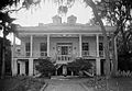
| 12 | Milner House |
.jpg) |
(#72000692) |
|
720 East Beach Boulevard 30°22′32″N 89°03′48″W / 30.375531°N 89.063267°W |
Gulfport | Known as Grass Lawn. Destroyed by Hurricane Katrina August 29, 2005. |
| 13 | Pleasant Reed House |
 |
(#79001308) |
|
928 Elmer Street |
Biloxi | Destroyed by Hurricane Katrina August 29, 2005. |
| 14 | Toledano-Philbrick-Tullis House |
.jpg) |
(#76001095) |
|
360 East Beach Boulevard 30°23′35″N 88°52′18″W / 30.393056°N 88.871667°W |
Biloxi | Destroyed by Hurricane Katrina August 29, 2005. |
Images for kids
-
The E. Barq Pop Factory, where Barq's root beer was first made.
-
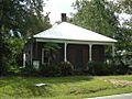
The Thomas and Melinda Benton House, built around 1870.
-
The Bond-Grant House, now the Biloxi Visitor's Center.
-
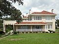
The G.B. Dantzler House, built in Spanish style.
-
The Gulf Coast Center for the Arts, formerly the Biloxi Public Library.
-
The Hewes Building in Gulfport, built in 1903-04.
-
A historic house at 638 East Howard Avenue.
-
The Nativity BVM Cathedral in Biloxi, built in 1902.
-
The Peoples Bank of Biloxi, built in 1914.
-
The W.J. Quarles House in Long Beach.
-
The Redding House, built in 1908.
-
The Scherer House, also known as the Spanish House.
-
The Suter House, a private residence built around 1885.
-
The Glenn Swetman House, built in 1926.
-
The U.S. Post Office and Customhouse in Gulfport.
-
The H.S. and Mattie M. Walker House.
-
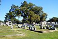
A view within the Old Biloxi Cemetery, part of the West Beach Historic District.
-
A historic house at the intersection of Seal Avenue and West Howard Avenue.
-
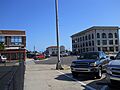
An image from the former Harbor Square Historic District in Gulfport.
-
The Hermann House, destroyed by Hurricane Katrina.
-
The Milner House, also known as Grass Lawn, destroyed by Hurricane Katrina.
-
A drawing of the Pleasant Reed House, destroyed by Hurricane Katrina.
-
The Toledano-Philbrick-Tullis House, destroyed by Hurricane Katrina.
