
National Register of Historic Places listings in Mariposa County, California facts for kids

Welcome to Mariposa County, California! This amazing place is home to some truly special spots, especially inside Yosemite National Park. Many of these places are so important that they've been added to a special list called the National Register of Historic Places. Think of it like a hall of fame for old buildings, areas, and sites that tell important stories about history.
Contents
What is the National Register of Historic Places?
The National Register of Historic Places is an official list kept by the United States government. It helps protect and celebrate places that are important to American history, architecture, archaeology, engineering, or culture. When a place is on this list, it means it's recognized as a valuable part of our past. In Mariposa County, there are 45 places on this list! Four of them are even more special and are called National Historic Landmarks, which are the very best of the best.
Historic Gems in Yosemite National Park
Yosemite National Park is full of incredible natural beauty, but it also has many historic sites. These places show how people have lived, worked, and explored this famous park over the years.
The Ahwahnee Hotel
The Ahwahnee Hotel is a grand and beautiful hotel located right in Yosemite Valley. It was built in 1927 and is famous for its amazing design, which blends into the natural surroundings. It's a National Historic Landmark because it's a great example of park architecture.

Camp 4
Camp 4 is a campground in Yosemite Valley that's super famous among rock climbers. It's been a gathering spot for climbers for many years and is known as the birthplace of modern rock climbing. It's a simple place, but its history makes it very special.

Curry Village Historic District
Curry Village is a historic area in Yosemite Valley that has been providing lodging and services to visitors since 1899. It was started by David and Jennie Curry, who wanted to make Yosemite accessible to everyone. It's a district because it includes many different buildings and areas that tell its story.

Half Dome Cables and Trail
The Half Dome Cables and Trail is part of one of the most famous and challenging hikes in Yosemite. The cables were put in place to help hikers climb the steep, smooth granite of Half Dome. This trail has been used for a long time and is an important part of the park's history of outdoor adventure.

LeConte Memorial Lodge
The LeConte Memorial Lodge is a historic stone building in Yosemite Valley. It was built in 1903 by the Sierra Club as a tribute to Joseph LeConte, a professor and early environmentalist. It served as the first public visitor center in the park and is still used for educational programs today.

Rangers' Club
The Rangers' Club in Yosemite Valley was built in 1924. It was one of the first buildings designed specifically for park rangers. It helped create a sense of community for the rangers who worked to protect the park. It's a National Historic Landmark.
.jpg)
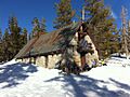
Yosemite Valley Chapel
The Yosemite Valley Chapel is a beautiful little church built in 1879. It's the oldest building in Yosemite Valley that has been continuously used for its original purpose. It's a popular spot for weddings and services, surrounded by the stunning scenery of the park.

Wawona Hotel and Pavilion
The Wawona Hotel is another historic hotel located in the southern part of Yosemite National Park. It first opened in 1876 and is known for its charming Victorian style. It's a National Historic Landmark and has welcomed visitors for over a century.

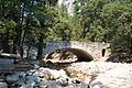
Wawona Covered Bridge
Near the Wawona Hotel is the Wawona Covered Bridge, built in 1878. This wooden bridge is one of the few remaining covered bridges in California. It's a lovely example of old-time engineering and a popular spot for photos.

Historic Towns and Buildings in Mariposa County
Beyond Yosemite, Mariposa County has other historic places that tell stories of the California Gold Rush and early settlements.
Coulterville Main Street Historic District
Coulterville is a small town that was once a busy mining center during the Gold Rush. The Coulterville Main Street Historic District includes many of the old buildings along its main street. Walking through Coulterville feels like stepping back in time to the 1800s.

Mariposa County Courthouse
The Mariposa County Courthouse in the town of Mariposa is a very special building. It was built in 1854 and is the oldest courthouse in California that is still being used today! It's a beautiful example of early California architecture.

Mariposa Town Historic District
The Mariposa Town Historic District covers a larger area of downtown Mariposa, including the courthouse and many other old buildings. This district shows how the town grew during the Gold Rush and how it has kept its historic charm.

Hornitos Masonic Hall No. 98
The Hornitos Masonic Hall No. 98 is in the small, historic town of Hornitos. This building was used by the Masons, a fraternal organization, and is an important part of the town's history from the Gold Rush era.
.jpg)
St. Joseph Catholic Church, Rectory and Cemetery
In Mariposa, the St. Joseph Catholic Church, Rectory and Cemetery is another historic site. The church was built in 1862 and is a beautiful example of early religious architecture in the area. The church, rectory (where the priest lives), and cemetery together tell a story of faith and community in Mariposa.

Other Cool Historic Sites
Mariposa County also has other interesting historic places, from old railroad engines to unique cabins.
Hetch Hetchy Railroad Engine No.6
The Hetch Hetchy Railroad Engine No.6 is an old steam locomotive located in El Portal. This engine was part of the railroad that helped build the Hetch Hetchy Dam and reservoir, which provides water to San Francisco. It's a cool piece of transportation history.

McCauley and Meyer Barns
The McCauley and Meyer Barns are historic barns located north of El Portal, within Yosemite National Park. These barns represent the early ranching and farming history in the area before it became a national park.

McGurk Cabin
The McGurk Cabin is a small, rustic cabin located south of Yosemite Village. It was built by a prospector named John McGurk in the late 1800s. It's a simple structure, but it shows what life was like for early settlers and adventurers in the Yosemite area.

These are just some of the many historic places in Mariposa County that are listed on the National Register of Historic Places. Each one helps us understand the rich history of this beautiful part of California.
Images for kids
-

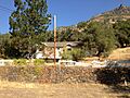
The Acting Superintendent's Headquarters in Wawona.
-
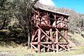
The Bagby Stationhouse, Water Tanks and Turntable.
-

The Crane Flat Fire Lookout.
-
The El Portal Old Schoolhouse.
-
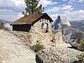
The Glacier Point Trailside Museum.
-
The Hodgdon Homestead Cabin.
-
The Chris Jorgenson Studio.
-
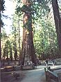
Mariposa Grove Museum, near giant sequoias.
-

The Yosemite Transportation Company Office.
-
One of the Yosemite Valley Bridges.
-

Yosemite Valley Railroad Caboose No. 15.
-
A building in the Yosemite Village Historic District.
-
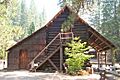
The Ostrander Lake Ski Hut.


