
National Register of Historic Places listings in Navajo County, Arizona facts for kids

This page is all about special places in Navajo County, Arizona, United States! These places are so important that they are listed on something called the National Register of Historic Places. Think of it like a special hall of fame for buildings, ruins, and areas that tell us a lot about history.
There are 55 of these amazing places in Navajo County. Three of them are even more special and are called National Historic Landmarks. This means they are super important to the history of the whole country!
Contents
What is the National Register of Historic Places?
The National Register of Historic Places is an official list kept by the United States government. It helps protect and celebrate places that are important to American history, architecture, archaeology, engineering, or culture. When a place is on this list, it means it's recognized for its unique story and value. It helps people learn about the past and keep these places safe for the future.
Navajo County has many different kinds of historic places. Some are very old, like ancient villages, while others are more recent, like old bridges or buildings. Let's look at a few examples!
Ancient Homes and Villages
Many places on the list are ancient ruins, showing us how people lived long ago.
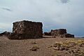
Agate House Pueblo
Imagine a house built from colorful wood! The Agate House Pueblo is a unique building made from petrified wood. It's located in Petrified Forest National Park near Holbrook. It shows us how early people used the materials around them to build their homes.
|- class="vcard" ! style="background:#A8EDEF" | 0 | Agate House Pueblo
|

|
(Ref. # missing)
| class="adr" | Petrified Forest National Park
Coordinates missing
| class="note" | A unique pueblo built from petrified wood.
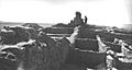
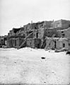
Awatovi Ruins
The Awatovi Ruins are a very important site near Keams Canyon. It was once a large Hopi village that existed for hundreds of years. It's a National Historic Landmark, meaning it's super important to the history of the entire country.
|- class="vcard" ! style="background:#A8EDEF" | 0 | Awatovi Ruins
|

|
(Ref. # missing)
| class="adr" | West of Jeddito
Coordinates missing
| class="note" | A very important ancient Hopi village site.
Homolovi Ruins
Near Winslow, there are several ancient villages known as the Homolovi Ruins (Homolovi I, II, III, and IV). These sites were home to the ancestors of today's Hopi people. They teach us about ancient farming, pottery, and community life in Arizona.
|- class="vcard" ! style="background:#A8EDEF" | 0 | Homolovi Four (IV)
|

|
(Ref. # missing)
| class="adr" | Address Restricted
| class="note" | One of several ancient Hopi ancestral villages.
|- class="vcard" ! style="background:#A8EDEF" | 0 | Homolovi I Ruin
|

|
(Ref. # missing)
| class="adr" | Address Restricted
| class="note" | Another important ancient Hopi ancestral village.
|- class="vcard" ! style="background:#A8EDEF" | 0 | Homolovi II
|

|
(Ref. # missing)
| class="adr" | Address Restricted
| class="note" | A large ancient Hopi ancestral village site.
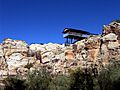
Old Oraibi
Old Oraibi is another National Historic Landmark on the Hopi Reservation. It's one of the oldest continuously inhabited settlements in North America! People have lived there for hundreds of years, making it a living piece of history.
|- class="vcard" ! style="background:#A8EDEF" | 0 | Old Oraibi
|

|
(Ref. # missing)
| class="adr" | Hopi Indian Reservation
Coordinates missing
| class="note" | One of the oldest continuously inhabited places in North America.
Historic Buildings and Districts
Many places on the list are buildings or groups of buildings that show us what life was like in more recent times.
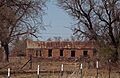
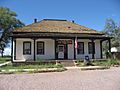
Fort Apache Historic District
The Fort Apache Historic District is a National Historic Landmark located on the Fort Apache Indian Reservation. It was an important military post in the past and now tells the story of the Apache people and their interactions with the U.S. Army.
|- class="vcard" ! style="background:#A8EDEF" | 0 | Fort Apache Historic District
|

|
(Ref. # missing)
| class="adr" | South of Whiteriver off State Route 73 on the Fort Apache Indian Reservation
Coordinates missing
| class="note" | An important historic military post and cultural site.
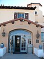
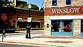
La Posada Historic District
In Winslow, the La Posada Historic District includes the famous La Posada Hotel. This hotel was designed by a famous architect named Mary Colter and was a popular stop for travelers on the Santa Fe Railway. It's a beautiful example of old train travel and architecture.
|- class="vcard" ! style="background:#A8EDEF" | 0 | La Posada Historic District
|

|
(Ref. # missing)
| class="adr" | 200 E. 2nd St.
Coordinates missing
| class="note" | A historic hotel and train station designed by Mary Colter.
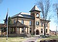
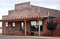
The Navajo County Courthouse in Holbrook is a grand old building that has served as the center of local government for many years. It's a great example of the architecture from its time and holds many stories of the county's past.
|- class="vcard" ! style="background:#A8EDEF" | 0 | Navajo County Courthouse
|

|
(Ref. # missing)
| class="adr" | Courthouse Sq.
Coordinates missing
| class="note" | The historic center of government for Navajo County.
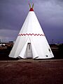
Wigwam Village No. 6
Have you ever seen a motel shaped like a teepee? The Wigwam Village No. 6 in Holbrook is one of the few remaining "Wigwam Motels" in the United States. It's a fun and unique example of roadside architecture from the early days of car travel.
|- class="vcard" ! style="background:#A8EDEF" | 0 | Wigwam Village No. 6
|

|
(Ref. # missing)
| class="adr" | 811 W. Hopi Dr.
Coordinates missing
| class="note" | A unique motel with rooms shaped like teepees.
Bridges and Other Structures
Some historic places are not buildings but important structures like bridges.
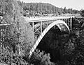
Cedar Canyon Bridge
The Cedar Canyon Bridge is an old bridge on U.S. Route 60 near Show Low. Old bridges like this are important because they show us how engineers built things in the past and how transportation has changed.
|- class="vcard" ! style="background:#A8EDEF" | 0 | Cedar Canyon Bridge
|

|
(Ref. # missing)
| class="adr" | U.S. Route 60 over Cedar Canyon at milepost 323.4
Coordinates missing
| class="note" | An historic bridge on U.S. Route 60.
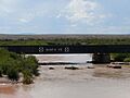
Holbrook Bridge (State Route 77)
This Holbrook Bridge carries State Route 77 over the Little Colorado River. It's a type of bridge called a Warren pony truss bridge from 1928, showing us older bridge building styles.
|- class="vcard" ! style="background:#A8EDEF" | 0 | Holbrook Bridge
|

|
(Ref. # missing)
| class="adr" | State Route 77 over the Little Colorado River
Coordinates missing
| class="note" | A historic Warren pony truss bridge from 1928.
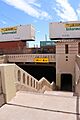
Winslow Underpass
The Winslow Underpass is a cool example of how roads were built to go under train tracks. This one carries State Route 87 under the ATSF railroad line in Winslow.
|- class="vcard" ! style="background:#A8EDEF" | 0 | Winslow Underpass
|

|
(Ref. # missing)
| class="adr" | State Route 87 under the ATSF railroad line at milepost 342.1
Coordinates missing
| class="note" | An historic underpass for State Route 87 beneath a railroad.
Images for kids
-
Agate House Pueblo
-
Awatovi Ruins
-
Baird's Chevelon Steps
-
Brigham City
-
Cedar Canyon Bridge
-
Chevelon Creek Bridge
-

Corduroy Creek Bridge
-
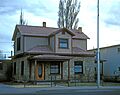
Abner Ellsworth House
-
Fort Apache Post Office
-
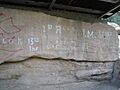
Inscription Rock
-

Jack's Canyon Bridge
-
La Posada Hotel
-
Navajo County Courthouse
-
Old Oraibi
-
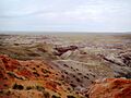
Painted Desert Petroglyphs
-
Sidney Sapp House
-
Wigwam Village No. 6
-
Winslow Bridge
-
Winslow Commercial Historic District
-
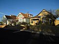
Winslow Residential Historic District
-
Winslow Underpass
-
Homolovi Four
-

Homolovi I Ruin
-

Homolovi II Ruin
-
Lorenzo Hubbell Trading Post and Warehouse


_from_S_1.JPG)


| Holbrook | Keams Canyon | Winslow | Winslow | Winslow | Oraibi | Whiteriver | Winslow | Holbrook | Holbrook | Show Low | Holbrook | Winslow |
