
National Register of Historic Places listings in Portage County, Ohio facts for kids

This page lists many historic places in Portage County, Ohio. These special places are part of the National Register of Historic Places. It's like a national list of buildings, sites, and objects that are important to American history, architecture, archaeology, engineering, or culture.
Portage County is in Ohio, United States. There are 49 places in Portage County that are currently on this important list. Two other places were once on the list but have since been removed.
Contents
What are Historic Places?
The National Register of Historic Places is the official list of the nation's historic places. It helps us save and celebrate buildings, sites, and objects that tell important stories about our past. When a place is added to this list, it means it's recognized as special and worth protecting for future generations.
Historic Treasures in Portage County
Portage County is home to many fascinating historic places. These include old churches, grand houses, important industrial sites, and even places where big events happened. Let's explore some of them!
Cool Buildings and Homes
Many of the places on the list are old buildings and homes that show us how people lived and worked long ago.
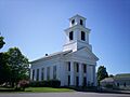
- The Atwater Congregational Church in Atwater Township was listed in 1973. It's a beautiful old church building.
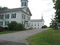
- The Aurora Center Historic District in Aurora is not just one building, but a whole area with many historic buildings. It was added to the list in 1974.
- The Aurora Train Station is another historic spot in Aurora, listed in 1986. Imagine all the people who passed through there!
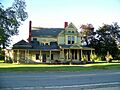
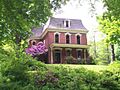
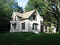
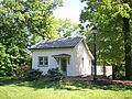
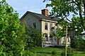
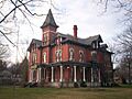
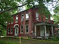
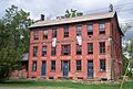
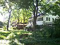
- The Horace Y. Beebe House and John F. Byers House are two historic homes in Ravenna Township, listed in 1983 and 2008.
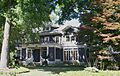
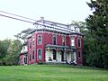
- The William H. Crafts House and Horace L. Hine House are historic homes in Mantua, listed in 1982 and 1976.
- The John Davey House in Kent was listed in 1975. John Davey was famous for starting the tree care industry!
- The Ellenwood House near Garrettsville, listed in 1975, is another interesting old home.
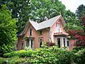
- The Aaron Ferrey House in Kent, listed in 1974, is also a notable historic residence.
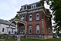
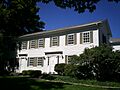
- The James A. Garfield House in Hiram was listed in 1975. This house belonged to James A. Garfield, who later became the 20th President of the United States!
- The Luman Nelson House in Shalersville Township, listed in 1993, is another example of a historic home.
- The Frederick Wadsworth House in Edinburg Township, listed in 1975, is a historic farm property.
- The Thomas F. Young House in Hiram, listed in 1976, is another important historic residence.
Important Event Sites
Some places are important because of big events that happened there.
- The Kent State Shootings Site in Kent was listed in 2010. This site is very important because a sad event happened there on May 4, 1970, during a time of protests.
Old Businesses and Public Spots
Many historic places are buildings that were once busy businesses or important public spaces.
- The Cleveland Worsted Mills Redfern Mill in Ravenna, listed in 1988, was an important industrial building.
- The John Diver House and Storebuilding in Deerfield Township, listed in 1982, shows how people lived and ran businesses in the past.
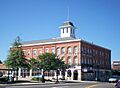
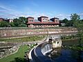
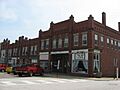
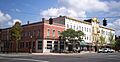
- The East Main Street Historic District in Ravenna, listed in 1985, is a whole area of historic business buildings.
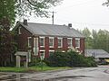
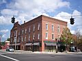
- The Etna House in Ravenna, listed in 1985, was likely an old hotel or inn.
- The Franklin Hotel in Kent, listed in 2013, is another historic hotel.
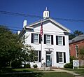
- The Franklin Township Hall in Kent, listed in 1975, was an important meeting place for the community.
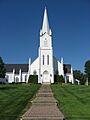
- The Freedom Congregational Church in Freedom Township, listed in 1975, is a historic church.
- The L.N. Gross Company Building in Kent, listed in 2016, was part of the area's industry.
- The Kent Industrial District in Kent, listed in 1974, is an area that shows the history of factories and businesses in the city.
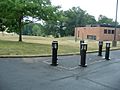
- The Kent Jail in Kent, listed in 2001, is an old jail building.
- The Charles Kent House and Zeno Kent House in Kent and Aurora, listed in 1978 and 1973, are historic homes.
- The Mantua Center District and Mantua Station Brick Commercial District in Mantua Township and Mantua, listed in 1974, are historic areas with many old buildings.
- The Mantua Center School in Mantua Township, listed in 2013, is a historic school building.
- The Masonic Temple in Kent, listed in 1974, is a historic meeting hall.
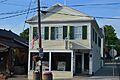
- The Mott Drug Store in Garrettsville, listed in 1996, was an old pharmacy.
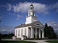
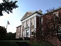
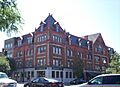
- The Ohio State Normal College at Kent (now part of Kent State University) in Kent, listed in 1975, is a historic part of the university campus.
- The Palmyra Center Hotel in Palmyra Township, listed in 1976, was an old hotel.
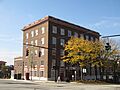
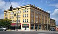
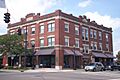
- The Phoenix Block, C.A. Reed House, Riddle Block, Riddle Block No. 5, Riddle Block No. 9, and Riddle Block No. 11 are all historic buildings or groups of buildings in Ravenna, listed in the 1980s. They show the city's past.
- The West Main Street District in Kent, listed in 1977, is another area with many historic buildings.
Places That Used to Be Historic
Sometimes, places are removed from the National Register of Historic Places. This can happen if they are changed too much, or if they are taken down.
- The Brown-Kent Tannery in Kent was once on the list but was removed in 1976. A tannery is a place where animal hides are made into leather.
- The Cascade House near Garrettsville was removed from the list in 1999.
- The Benjamin F. Hopkins Stone Building in Kent was also removed from the list because it was taken apart.
Images for kids
-
Atwater Congregational Church
-
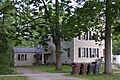
The Church in Aurora, part of the Aurora Center Historic District
-
Aurora Train Station
-
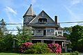
Horace Y. Beebe House
-
John F. Byers House
-
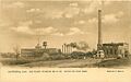
Cleveland Worsted Mills Redfern Mill
-
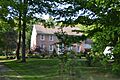
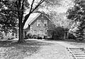
Cottage Hill Farm
-
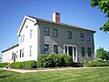
William H. Crafts House
-
Crystal Lake Stock Farm
-
John Davey House
-
John Diver House
-
East Main Street Historic District in Ravenna
-
Ellenwood House
-
Etna House
-
Aaron Ferrey House
-
Franklin Hotel in Kent
-
Franklin Township Hall
-
Freedom Congregational Church
-
James A. Garfield House
-
A.B. Griffin-O.H. Griffin House
-
Alexander B. Griffin House
-
Horace L. Hine House
-
C.R. Howard House
-
John Johnson Farm
-
Kent Industrial District
-
Kent Jail
-
Charles Kent House
-
Zeno Kent House
-
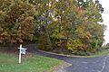
Kent State Shootings Site
-
Mantua Center District
-
Mantua Center School
-
Mantua Station Brick Commercial District
-
Masonic Temple in Kent
-
Mott Drug Store
-
Luman Nelson House
-
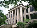
Ohio State Normal College at Kent (Merrill Hall)
-
Arvin Olin House (now demolished)
-
Palmyra Center Hotel
-
Phoenix Block
-
C.A. Reed House
-
Riddle Block
-
Riddle Block No. 5
-
Riddle Block No. 9
-
Riddle Block No. 11
-
Frederick Wadsworth House
-
West Main Street District in Kent
-
Thomas F. Young House
-
Benjamin F. Hopkins Stone Building site


