
National Register of Historic Places listings in Shasta County, California facts for kids

Have you ever wondered about old buildings or special places that tell a story about the past? In Shasta County, there are many such places! These important spots are listed on the National Register of Historic Places. This is a special list kept by the United States government. It helps protect places that are important to history, architecture, or even archaeology.
When a place is on this list, it means it's recognized for its unique value. It helps people learn about the past and makes sure these places are preserved for future generations. Shasta County has 29 different properties and areas on this list. Let's explore some of them!
What is the National Register of Historic Places?
The National Register of Historic Places is like a hall of fame for important places in the United States. It's managed by the National Park Service. This list includes buildings, sites, objects, structures, and even entire historic districts. To be on the list, a place must be important in American history, architecture, archaeology, engineering, or culture.
Being on the Register doesn't mean the government owns the property. It just means it's recognized as special. It also helps protect these places from certain types of development. It can also make them eligible for grants or tax benefits to help with their upkeep.
Historic Buildings and Theaters
Shasta County has several buildings that are famous for their history or unique design. These places often show us how people lived and worked long ago.
The Cascade Theatre
The Cascade Theatre is a beautiful old movie theater in Redding. It was built in 1935. This theater is a great example of the "Art Deco" style of architecture. This style was very popular in the 1920s and 1930s. The Cascade Theatre was a popular spot for movies and shows for many years. It has been carefully restored so people can still enjoy its beauty today.
The Lorenz Hotel
Also in Redding, the Lorenz Hotel is another historic building. It was added to the National Register in 2012. Hotels like the Lorenz were once busy centers of town life. Travelers would stay there, and local people would gather in its lobbies and restaurants. It shows us what travel and hospitality were like in earlier times.
Old City Hall Building
The Old City Hall Building in Redding is important because it was where the city's government used to operate. Built in 1907, it's a good example of early 20th-century public buildings. It reminds us of how cities grew and organized themselves.
Pine Street School
The Pine Street School, built in 1922, was an important place for education in Redding. Schools are often central to a community's history. This building represents the growth of education in the area.
Historic Districts and Parks
Some places on the National Register are not just single buildings. They are entire areas or districts that have many historic features.
Cottonwood Historic District
The Cottonwood Historic District is located in Cottonwood. This area includes several buildings that show what a small California town looked like in the past. Walking through a historic district is like taking a step back in time.
French Gulch Historic District
French Gulch is a small town with a rich history, especially from the California Gold Rush era. The French Gulch Historic District preserves many of the old buildings and structures from that time. It helps us imagine what life was like for miners and settlers.
Shasta State Historic Park
Shasta State Historic Park is a very special place. It was once the county seat of Shasta County during the Gold Rush. Today, it's a park that preserves the ruins and restored buildings of the old town. You can see the old courthouse, general store, and other structures. It's a fantastic place to learn about California's Gold Rush history.
Lassen Volcanic National Park Highway Historic District
Lassen Volcanic National Park is famous for its volcanoes and beautiful nature. The Lassen Volcanic National Park Highway Historic District includes the historic roads and structures built within the park. These were often constructed by the Civilian Conservation Corps in the 1930s. They show how national parks were developed to allow visitors to explore and enjoy nature.
Ancient Sites and Petroglyphs
Shasta County is also home to very old sites that tell us about the people who lived here thousands of years ago. These are often archaeological sites.
Cow Creek Petroglyphs and Dersch-Taylor Petroglyphs
Petroglyphs are ancient rock carvings. The Cow Creek Petroglyphs and Dersch-Taylor Petroglyphs are examples of these. They are very old and were made by early Native American people. These carvings are like ancient art and messages left on rocks. They give us clues about the beliefs and lives of the first people in this area. Because these sites are so fragile and important, their exact locations are often kept secret to protect them.
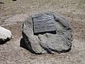
Reading Adobe Site
The Reading Adobe Site near Cottonwood is another important historical spot. An adobe is a type of building made from sun-dried earth bricks. This site is where one of the earliest American settlements in the area was located. It belonged to Pierson B. Reading, an early pioneer in California.
Lake Britton Archeological District
The Lake Britton Archeological District near Burney contains evidence of ancient human activity. Archaeological districts are areas where scientists have found many artifacts and signs of past cultures. These sites help us understand how people lived, hunted, and gathered food in this region long ago.
Other Notable Listings
Many other places in Shasta County are recognized for their historical importance.
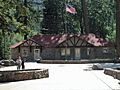
Horseshoe Lake Ranger Station and Summit Lake Ranger Station
These ranger stations are located within Lassen Volcanic National Park. They are important examples of early park service buildings. They show how rangers lived and worked to protect our national parks.
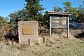
Nobles Emigrant Trail
The Nobles Emigrant Trail is a historic wagon trail that pioneers used to travel to California in the 1800s. It was a difficult journey, and this trail was a key route for many settlers. Parts of this trail are preserved within Lassen Volcanic National Park.
Prospect Peak Fire Lookout
Fire lookouts are towers used to spot wildfires in forests. The Prospect Peak Fire Lookout is an example of these important structures. They played a crucial role in protecting forests and communities from fires.
These are just some of the amazing historic places in Shasta County. Each one has a unique story to tell about the past!
Images for kids
-
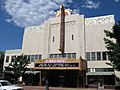
The beautiful Cascade Theatre in Redding, built in 1935.
-
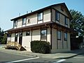
A building in the Cottonwood Historic District.
-
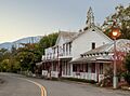
Historic buildings in the French Gulch Historic District.
-
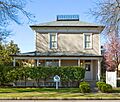
The Edward Frisbie House in Redding.
-
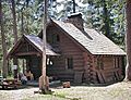
The Horseshoe Lake Ranger Station in Lassen Volcanic National Park.
-
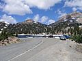
A view of the historic Lassen Volcanic National Park Highway.
-
The Loomis Visitor Center, also known as the Loomis Museum, in Lassen Volcanic National Park.
-
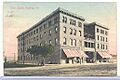
An old postcard showing the Lorenz Hotel in Redding.
-
The Loomis Art House, part of the Manzanita Lake Naturalist's Services Historic District.
-
A plaque marking the Nobles Emigrant Trail.
-
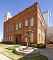
The Old City Hall Building in Redding.
-
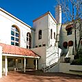
The courtyard of the historic Pine Street School.
-
A plaque at the Reading Adobe Site.
-
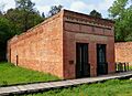
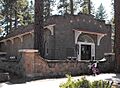
The Callaghan Block in Shasta State Historic Park.
-
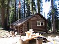
The Summit Lake Ranger Station in Lassen Volcanic National Park.


