
Necanicum River facts for kids
Quick facts for kids Necanicum River |
|
|---|---|

The river as it flows through Seaside near its outlet to the Pacific Ocean
|
|

Location of the mouth of the Necanicum River in Oregon
|
|
| Country | United States |
| State | Oregon |
| County | Clatsop |
| Physical characteristics | |
| Main source | Northern Oregon Coast Range Humbug Mountain, Clatsop County, Oregon 1,847 ft (563 m) 45°55′37″N 123°42′30″W / 45.92694°N 123.70833°W |
| River mouth | Pacific Ocean At Seaside, Clatsop County, Oregon 7 ft (2.1 m) 46°0′41″N 123°55′39″W / 46.01139°N 123.92750°W |
| Length | 21 mi (34 km) |
| Basin features | |
| Basin size | 83.7 sq mi (217 km2) |

The Necanicum River is a cool river located on the Pacific coast in northwest Oregon, United States. It's about 21 miles (34 km) long. This river helps drain a forest area in the Northern Oregon Coast Range. It forms the first estuary (where a river meets the sea) south of the big Columbia River. The Necanicum River finally flows into the Pacific Ocean at a town called Seaside in Clatsop County.
| Top - 0-9 A B C D E F G H I J K L M N O P Q R S T U V W X Y Z |
River's Name and History
The name Necanicum comes from an old Native American name, Ne-hay-ne-hum. This was the name of a village that used to be along the river.
- Early Names: In 1806, a famous explorer named William Clark tried to call it the "Clatsop River," but that name didn't stick.
- Latty Creek: For a while, people also called it "Latty Creek" after an early settler named William Latty.
Where the River Flows
The Necanicum River starts high up near Humbug Mountain in south-central Clatsop County, Oregon. Its source is about 1,847 feet (563 meters) above sea level.
- River's Journey: It generally flows west, following along U.S. Route 26.
- Turning North: About 3 miles (5 km) from the coast, it turns north.
- Reaching the Ocean: The river enters the Pacific Ocean at Seaside. Its path to the ocean runs almost parallel to the coast, flowing from south to north right through downtown Seaside.
The area of land that the Necanicum River and its smaller streams drain is called its watershed. This watershed covers about 83.7 square miles (217 km2).
Smaller Streams Joining the River
As the Necanicum River flows downstream, many smaller streams, called tributaries, join it. Some of the named ones include:
- Grindy Creek
- Bergsvik Creek
- Little Humbug Creek
- North Fork Necanicum River
- South Fork Necanicum River
- Mail Creek
- Klootchy Creek
- Beeman Creek
- Circle Creek
- Neawanna Creek
- Neacoxie Creek (This is the last tributary before the river reaches the ocean, flowing in from the north.)
Long ago, Cullaby Lake and Cullaby Creek used to flow into the Necanicum River through Neacoxie Creek. However, a project called the Clatsop Canal Project changed this. Now, they drain into the Skipanon River instead.
Wildlife and River Protection
The Necanicum River watershed is a very important place for many types of fish, especially anadromous fish. These are fish that live in both fresh water and salt water. They are born in fresh water, go to the ocean to grow, and then return to fresh water to lay their eggs.
Important Fish Species
Several types of salmon and trout use the Necanicum River for breeding, growing, and laying eggs. These include:
- Chinook salmon (Oncorhynchus tshawytscha)
- Coho salmon (O. kisutch)
- Chum salmon (O. keta)
- Steelhead (O. mykiss irideus)
- Sea-run cutthroat trout (O. clarki clarki)
Other fish found in the river include resident cutthroat trout, rainbow trout, and Pacific lamprey (Entosphenous tridentatus).
Coho Salmon and Their Habitat
Coho salmon use almost the entire Necanicum River watershed. However, even with all this habitat, the number of coho salmon has become quite small. Surveys from 1990 to 2000 showed that only about 600 coho salmon were using the river each year.
Coho salmon like streams that are complex. This means streams with lots of large pieces of wood, wide floodplains, braided channels (where the river splits into smaller paths), beaver ponds, and sometimes lakes.
- Challenges for Salmon: Unfortunately, human activities have harmed this important habitat. These activities include cutting down trees, mining, taking too much water from the river, livestock grazing, building roads, changing river channels, building dikes in wetlands, and city growth.
- Historical Harvest: In the mid-1800s, three Native American tribes would gather in the Necanicum estuary every fall to catch salmon.
Wetland Restoration Project
In 2006, a project called the Thompson Creek-Stanley Marsh wetland restoration began. The North Coast Land Conservancy started opening up ditches that bordered 80 acres (32 hectares) of pastureland. The goal was to turn this land back into a healthy Sitka spruce (Picea sitchensis) wetland.
- Beavers Helping Out: They added large pieces of wood and planted native willow, alder, spruce, and other wetland plants. This attracted beavers, who built several dams. The beavers helped speed up the process of turning the pasture back into a wetland.
- Positive Results: The number of coho salmon in Thompson Creek, a stream that flows into Neawanna Creek, is already increasing. By letting beavers do most of the work instead of using expensive digging and restoration methods, the project saved an estimated $60,000 to $80,000.
Other Animals in the Watershed
The Necanicum River watershed is also a vital home for many other animals, such as:
- Roosevelt elk (Cervus canadensis roosevelti)
- Black-tailed deer (Odocoileus hemionus)
- Beaver (Castor canadensis)
- North American river otters (Lontra canadensis)
- Northern red-legged frog (Rana aurora)
- A wide variety of birds, including year-round residents like great blue herons (Ardea herodias) and migrating birds like barn and tree swallows (Hirundo rustica and Tachycineta bicolor).
Images for kids
-
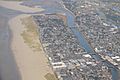
Aerial image of the river flowing south-to-north until turning west to the Pacific
-
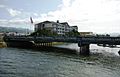
A bridge over the river in the town of Seaside
-
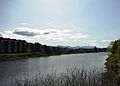
Flowing through the town of Seaside
-
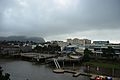
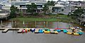
The river in the town of Seaside with boat rental pier
-
Seaside Convention Center with boat rental pier
-
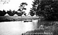
Historic photo: On the banks of the river near Hotel Moore in Seaside


.jpg)
