
Nevado de Longaví facts for kids
Quick facts for kids Nevado de Longaví |
|
|---|---|

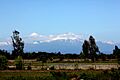
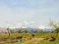
Photo of Nevado de Longaví from the cordillera of Linares
|
|
| Highest point | |
| Elevation | 3,242 m (10,636 ft) |
| Listing | List of volcanoes in Chile |
| Geography | |

Nevado de Longaví
Location in Chile
|
|
| Parent range | Andes |
| Geology | |
| Mountain type | Stratovolcano |
| Last eruption | 4890 BCE ± 75 years |
Nevado de Longaví is a tall volcano in the Andes mountains of central Chile. It stands at 3,242 meters (10,636 feet) high. This volcano is located in the Linares Province, which is part of the Maule Region.
Nevado de Longaví has a main crater at its top. It also has smaller openings, called parasitic vents, on its sides. The volcano is mostly made up of hardened lava flows. Over time, parts of the volcano have collapsed. This created two large scars on its slopes. One is on the eastern side, called Lomas Limpias. The other is on the southwestern side, known as Los Bueyes.
A glacier can be found on the volcano. Important rivers like the Achibueno and Blanco rivers start their journey from this mountain.
The oldest volcanic activity here happened about one million years ago. The volcano's rocks have a special chemical makeup. Scientists think this might be because the magma was very rich in water. This could be due to a crack in the Earth's crust, called the Mocha fracture zone, sinking beneath the volcano.
Nevado de Longaví was active during the Holocene period. About 6,835 to 7,500 years ago, a big explosive eruption happened. It sent light, airy rocks called pumice more than 20 kilometers (12 miles) away. Later, a lava flow covered this pumice. The last eruption was about 5,700 years ago. It formed a lava dome near the top. The volcano has not erupted in recorded history. However, it still has fumaroles, which are vents that release steam and gases. The National Geology and Mining Service of Chile keeps an eye on Nevado de Longaví.
Contents
Where is Nevado de Longaví?
Nevado de Longaví is located in the Longaví commune. This area is part of the Linares Province in the Maule Region of Chile.
Part of a Big Mountain Range

Nevado de Longaví is part of the Andes Mountain Range. Specifically, it's in a section called the Southern Volcanic Zone. This zone stretches across Chile and Argentina. It includes about 60 volcanoes. Some very large eruptions in this area were the 1932 Quizapu and the 1991 Cerro Hudson eruptions.
Nevado de Longaví is in a special part of this zone. This area is known for having different types of volcanic rocks. It also has varying thicknesses of the Earth's crust beneath the volcanoes.
How the Volcano Formed
Volcanoes in the Southern Volcanic Zone form because of plate tectonics. The Nazca Plate is slowly sliding under the South American Plate. This happens in a deep ocean trench called the Peru–Chile Trench. This movement causes magma to form deep underground.
The Southern Volcanic Zone is one of several volcanic belts in the Andean Volcanic Belt. There are gaps where no volcanoes are found. These gaps happen where other underwater mountain ranges, like the Juan Fernández Ridge, sink beneath the continent. In these areas, magma doesn't form as easily.
Local Features of Longaví
-
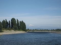
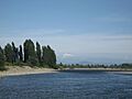
View on Longavi from the Achibueno River at Palmilla, Linares
-
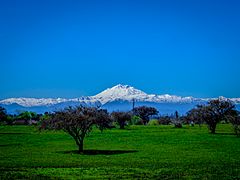
View on Longavi from Parral, Linares
-

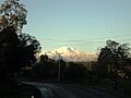
Longavi from route L-75 Parral-Digua
-
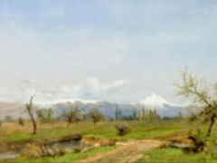
An oil painting depicting Longavi from 1859


Nevado de Longaví is part of a small mountain chain. Its accepted height is 3,242 meters (10,636 feet). The volcano has a main summit crater at its top. It also has many smaller craters on its slopes. The main crater is quite old and worn down by erosion.
Lava flows spread out from the summit crater. These flows make up most of the volcano. The smaller craters also produced lava flows. These lava flows are often mixed with broken rock pieces. They can be 4 to 15 meters (13 to 49 feet) thick. Mudflows, called lahars, have also been found on the eastern slopes.
Large cliffs on the eastern and southeastern sides show where parts of the volcano collapsed. This collapse is called Lomas Limpias. Its scar covers about 2 square kilometers (0.77 square miles). Later, new volcanic material filled this scar. Another collapse happened on the southwestern side, forming the Los Bueyes area.
Nevado de Longaví is a medium-sized volcano. It is about 9 kilometers (5.6 miles) wide at its base. Its base covers an area of about 64 square kilometers (25 square miles). The volcano rises about 1,800 meters (5,900 feet) from its base. Its total volume is around 20 cubic kilometers (4.8 cubic miles).
The ground beneath the volcano is made of older rock layers. These include volcanic ash and rock from millions of years ago. There are also some other small, single-eruption volcanoes nearby. These include Villalobos, Resago, and Loma Blanca.

A glacier sits on the southern slope of Nevado de Longaví. Sadly, this glacier has shrunk a lot. Between 1989 and 2017, it lost over 95% of its ice. Less than 0.2 square kilometers (0.077 square miles) of glacier cover remains. Signs of past glaciers, like scratches on rocks, can also be seen.
Several rivers start on Nevado de Longaví. The Rio Blanco begins on the southeastern slope. The Estero Martinez and Quebrada Los Bueyes rivers also start here. They both flow into the Rio Blanco. The Achibueno River also starts on the eastern side of the volcano, from a lake.
What is Longaví Made Of?
Nevado de Longaví has mostly erupted a type of rock called andesite. This makes up about 80% of the volcano. Smaller amounts of basalt and dacite rocks have also erupted. Basalt was more common in the volcano's early days. Dacite erupted more recently, during the Holocene.
The rocks contain different types of crystals. Early rocks had crystals like clinopyroxene, olivine, and plagioclase. Later rocks also included amphibole and orthopyroxene. Rocks from the Holocene period have even more types of crystals, like apatite and iron oxides.
The chemical makeup of Nevado de Longaví's magma is quite special. For example, it has unusually low amounts of potassium. Scientists think the magma was very rich in water. This is also seen in other volcanoes like Mocho-Choshuenco and Calbuco. These volcanoes are located where cracks in the Earth's crust meet the Peru–Chile Trench. It is thought that these cracks help channel water deep into the Earth's mantle. For Nevado de Longaví, the Mocha fracture zone is sinking beneath it.
When Did Longaví Erupt?
The earliest lava flows from Nevado de Longaví are found on its northern and southwestern slopes. These flows are about 100 to 150 meters (330 to 490 feet) thick. Individual flows are about 1 to 5 meters (3.3 to 16.4 feet) thick. These rocks are up to one million years old.
During the volcano's main growth period, eruptions were fairly steady. However, there were times when the volcano was quiet. During these quiet times, erosion created valleys on the northern slope. Later, new lava flows filled these valleys.
Recent Activity (Holocene)
The most recent activity happened during the Holocene period. This included explosive eruptions. These eruptions were focused in the eastern collapse scar and near the summit.
About 6,835 to 7,500 years ago, a large explosive eruption took place. It sent dacitic pumice more than 20 kilometers (12 miles) southeast of the volcano. The pumice deposits can be up to 30 meters (98 feet) thick. This event is also known as the Rio Blanco fall deposit. In the eastern collapse scar, an andesitic lava flow later covered this pumice.
The very last eruption formed a lava dome within the collapse scar and the summit area. This happened about 5,700 years ago. A part of this lava dome later collapsed. It created a large flow of rock and ash. This flow traveled down the eastern slopes and covered about 4 square kilometers (1.5 square miles).
There are no records of Nevado de Longaví erupting in recent history. However, there is still some fumarolic activity. This means steam and gases are still coming out of the volcano. Satellites have also detected small heat changes. Scientists have looked into using the volcano's heat for geothermal energy. They estimate it could produce a lot of power.
Volcano Hazards
Nevado de Longaví is ranked 22 on Chile's national volcano hazard scale. This means it is considered a significant risk. Towns closest to the volcano include Cerro Los Castillos, La Balsa, La Orilla, Las Camelias, and Rincón Valdés.
If the volcano were to erupt again, it could cause several dangers:
- Debris flows: Fast-moving mixtures of rock, mud, and water.
- Eruption columns: Tall columns of ash and gas rising from the volcano.
- Lava flows: Streams of molten rock.
- Pyroclastic flows: Fast-moving, superheated clouds of gas and volcanic debris.
These hazards could affect the volcano itself and the valleys around it. Even the Mendoza Province in Argentina could be affected by ash from a large eruption.
The first recorded climb to the summit was in 1965 by S. Kunstmann and W. Foerster. However, they found signs that people had reached the top before them. Today, Nevado de Longaví is an important place for tourists in the area.
Images for kids
-
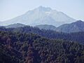
Photo of Nevado de Longaví from the cordillera of Linares
-
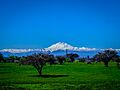
Nevado de Longaví seen from Parral, Chile
-
View on Longavi from the Achibueno River at Palmilla, Linares
-
View on Longavi from Parral, Linares
-
Longavi from route L-75 Parral-Digua
-
An oil painting depicting Longavi from 1859
-
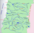
Rivers in Maule
See also
 In Spanish: Nevado de Longaví para niños
