Newmarket (CDP), New Hampshire facts for kids
Quick facts for kids
Newmarket, New Hampshire
|
|
|---|---|

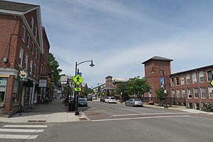
Main Street
|
|
| Country | United States |
| State | New Hampshire |
| County | Rockingham |
| Town | Newmarket |
| Area | |
| • Total | 2.32 sq mi (6.00 km2) |
| • Land | 2.25 sq mi (5.83 km2) |
| • Water | 0.07 sq mi (0.17 km2) |
| Elevation | 40 ft (10 m) |
| Population
(2020)
|
|
| • Total | 5,797 |
| • Density | 2,575.30/sq mi (994.16/km2) |
| Time zone | UTC-5 (Eastern (EST)) |
| • Summer (DST) | UTC-4 (EDT) |
| ZIP code |
03857
|
| Area code(s) | 603 |
| FIPS code | 33-52260 |
| GNIS feature ID | 2378083 |
Newmarket is a special kind of community called a census-designated place (CDP). It's the main village in the town of Newmarket, located in Rockingham County, New Hampshire, in the United States.
In 2020, about 5,797 people lived in this village. The whole town of Newmarket had a larger population of 9,430 residents.
Contents
Where is Newmarket Located?
Newmarket village is in the northeastern part of the town of Newmarket. It sits on both sides of the Lamprey River, right where the river meets the ocean's tides.
Nearby Areas and Rivers
To the north, Newmarket borders the town of Durham. To the northwest, it's near the Piscassic River, which flows into the Lamprey River.
Main Roads in Newmarket
New Hampshire Route 108 goes right through the middle of the village.
- If you go north on Route 108, you'll reach Durham and the University of New Hampshire in about 4 miles (6 km).
- If you go south, you'll get to Exeter in about 8 miles (13 km).
New Hampshire Route 152 heads west from Newmarket. It takes you to Nottingham, which is about 9 miles (14 km) away.
Land and Water Features
The Newmarket CDP covers a total area of about 2.32 square miles (6.0 square kilometers).
- Most of this area, about 2.25 square miles (5.8 square kilometers), is land.
- A smaller part, about 0.07 square miles (0.2 square kilometers), is water.
The Lamprey River flows through the village from north to south. In the 1800s, a large factory complex called the Newmarket Manufacturing Company mill was built on this river. The central part of Newmarket village is so important historically that it's listed on the National Register of Historic Places as the Newmarket Industrial and Commercial Historic District.
Who Lives in Newmarket?
The population of Newmarket village has grown over the years. Here's how many people have lived there during different census counts:
| Historical population | |||
|---|---|---|---|
| Census | Pop. | %± | |
| 1950 | 2,172 | — | |
| 1960 | 2,745 | 26.4% | |
| 1970 | 2,645 | −3.6% | |
| 1980 | 3,749 | 41.7% | |
| 1990 | 4,917 | 31.2% | |
| 2000 | 5,124 | 4.2% | |
| 2010 | 5,297 | 3.4% | |
| 2020 | 5,797 | 9.4% | |
| U.S. Decennial Census | |||
Population Details from 2010
In 2010, there were 5,297 people living in Newmarket village. These people lived in 2,400 different homes, and 1,178 of these were families.
- Most residents (91.2%) were white.
- About 4.0% were Asian.
- A small number were African American (1.3%), Native American (0.3%), or Pacific Islander (0.1%).
- About 2.3% of people were from two or more races.
- About 2.9% of the population identified as Hispanic or Latino.
Households and Families
- About 24.5% of homes had children under 18 living there.
- About 35.1% of homes were headed by married couples.
- About 9.7% of homes had a female head of household with no husband present.
- About 50.9% of homes were not families (meaning people living alone or with roommates).
- About 31.3% of all homes were made up of just one person.
- About 6.0% of homes had someone living alone who was 65 years old or older.
The average number of people in a home was 2.21, and the average family size was 2.82 people.
Age Groups
The people living in Newmarket village in 2010 were spread across different age groups:
- 18.0% were under 18 years old.
- 17.6% were between 18 and 24 years old.
- 32.2% were between 25 and 44 years old.
- 24.5% were between 45 and 64 years old.
- 7.7% were 65 years old or older.
The average age of residents was about 31.6 years. For every 100 females, there were about 98.1 males.
Income Information
From 2011 to 2015, the estimated average yearly income for a household in Newmarket village was $53,025. For families, the average yearly income was $73,990. The average income per person was $28,830.
About 12.0% of the total population and 3.5% of families lived below the poverty line. This included 5.3% of people under 18 and 6.8% of people 65 or older.
See also

- In Spanish: Newmarket (condado de Rockingham) para niños
 | Emma Amos |
 | Edward Mitchell Bannister |
 | Larry D. Alexander |
 | Ernie Barnes |


