Durham (CDP), New Hampshire facts for kids
Quick facts for kids
Durham, New Hampshire
|
|
|---|---|

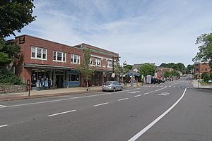
Main Street
|
|
| Country | United States |
| State | New Hampshire |
| County | Strafford |
| Town | Durham |
| Area | |
| • Total | 3.08 sq mi (7.98 km2) |
| • Land | 3.02 sq mi (7.84 km2) |
| • Water | 0.06 sq mi (0.15 km2) |
| Elevation | 60 ft (20 m) |
| Population
(2020)
|
|
| • Total | 11,147 |
| • Density | 3,684.96/sq mi (1,422.65/km2) |
| Time zone | UTC-5 (Eastern (EST)) |
| • Summer (DST) | UTC-4 (EDT) |
| ZIP code |
03824
|
| Area code(s) | 603 |
| FIPS code | 33-19620 |
| GNIS feature ID | 2378059 |
Durham is a special area in the town of Durham, located in Strafford County, New Hampshire, in the United States. It's called a census-designated place (CDP) because the U.S. Census Bureau defines it for gathering population data. In 2020, about 11,147 people lived in this part of Durham. The whole town of Durham had a population of 15,490 people. Durham is also famous for being the home of the University of New Hampshire.
Exploring Durham's Location
This special area of Durham is in the northern part of the town. It sits on the north side of the Oyster River. To the north, it shares a border with the town of Madbury.
Major roads help people get around Durham. U.S. Route 4 goes through the northern part of the CDP, but it goes around the main town center. This route can take you southeast about 9 miles (14 km) to Portsmouth. Or, if you head west, it's about 34 miles (55 km) to Concord, which is the state capital.
Another important road, New Hampshire Route 108, goes right through the middle of the CDP. It leads north about 5 miles (8 km) to Dover and south about 12 miles (19 km) to Exeter. The campus of the University of New Hampshire is located in the southwestern part of this area.
The Durham CDP covers a total area of about 3.08 square miles (8.0 square kilometers). Most of this area, about 3.02 square miles (7.8 square kilometers), is land. A smaller part, about 0.06 square miles (0.15 square kilometers), is water, like rivers or small streams.
Who Lives in Durham?
| Historical population | |||
|---|---|---|---|
| Census | Pop. | %± | |
| 1950 | 4,172 | — | |
| 1960 | 4,688 | 12.4% | |
| 1970 | 7,221 | 54.0% | |
| 1980 | 8,448 | 17.0% | |
| 1990 | 9,236 | 9.3% | |
| 2000 | 9,024 | −2.3% | |
| 2010 | 10,345 | 14.6% | |
| 2020 | 11,147 | 7.8% | |
| U.S. Decennial Census | |||
The number of people living in the Durham CDP is greatly affected by the University of New Hampshire. Many students live in dorms or other group housing.
In 2010, there were 10,345 people living here. Most of the people were white (93.1%). About 3.6% were Asian, and 1.0% were African American. About 2.3% of the population identified as Hispanic or Latino.
A large number of residents, 6,328 people, lived in places like college dorms instead of regular homes. This means many young adults live here. The average age in Durham CDP was about 20.5 years old in 2010. This is much younger than many other towns because of all the university students.
See also
 In Spanish: Durham (condado de Strafford) para niños
 | Chris Smalls |
 | Fred Hampton |
 | Ralph Abernathy |


