Nicholasville, Kentucky facts for kids
Quick facts for kids
Nicholasville, Kentucky
|
|
|---|---|

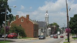
Main Street in Nicholasville, Kentucky
|
|

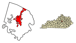
Location of Nicholasville in Jessamine County, Kentucky
|
|
| Country | United States |
| State | Kentucky |
| County | Jessamine |
| Incorporated | February 13, 1837 |
| Government | |
| • Type | City commission |
| Area | |
| • Total | 14.85 sq mi (38.45 km2) |
| • Land | 14.78 sq mi (38.27 km2) |
| • Water | 0.07 sq mi (0.18 km2) |
| Elevation | 994 ft (303 m) |
| Population
(2020)
|
|
| • Total | 31,093 |
| • Estimate
(2022)
|
31,955 |
| • Density | 2,104.29/sq mi (812.47/km2) |
| Time zone | UTC-5 (Eastern (EST)) |
| • Summer (DST) | UTC-4 (EDT) |
| ZIP Codes |
40340, 40356
|
| Area code(s) | 859 |
| FIPS code | 21-56136 |
| GNIS feature ID | 2404379 |
Nicholasville is a city in Kentucky, and it's the main town of Jessamine County. In 2020, about 31,490 people lived there. This makes Nicholasville the 10th largest city in Kentucky.
Since the late 1900s, Nicholasville has grown a lot. Its population increased by over 440% between 1970 and 2020! Many people who live here travel to Lexington for work. Nicholasville is also a busy place for shopping and jobs for people in central Kentucky.
Contents
History of Nicholasville
Nicholasville was started by European Americans in 1798, after the American Revolutionary War. It officially became a city in 1837. The town was named after Colonel George Nicholas. He helped create the first Kentucky Constitution in 1792.
The Young House in Nicholasville is a very old building. It is listed on the National Register of Historic Places, which means it's an important historical site. The city continues to grow and improve its roads for everyone.
Geography of Nicholasville
Downtown Nicholasville is about 6 miles south of Fayette County. The city is a key spot for travel and business between Lexington and nearby counties, like Garrard County. Nicholasville covers about 13.08 square miles. Most of this area is land, with a small part being water.
Some small lakes, like Lake Mingo, are found in the city. Lake Mingo is named after the Mingo people, a Native American group. A stream called Town Fork flows through the city, even going under downtown. It eventually drains into Jessamine Creek.
Nicholasville's Climate
Nicholasville has a humid subtropical climate. This means it has hot and humid summers, cool winters, and sometimes mild weather, especially in autumn. The area usually has four clear seasons. You can expect cool breezes, comfortable summer nights, and not too much long-lasting rain or snow.
Nicholasville's Population Growth
Nicholasville has seen a lot of growth over the years. Here's how the population has changed:
| Historical population | |||
|---|---|---|---|
| Census | Pop. | %± | |
| 1810 | 158 | — | |
| 1830 | 408 | — | |
| 1840 | 632 | 54.9% | |
| 1860 | 800 | — | |
| 1870 | 1,089 | 36.1% | |
| 1880 | 2,303 | 111.5% | |
| 1890 | 2,157 | −6.3% | |
| 1900 | 2,393 | 10.9% | |
| 1910 | 2,935 | 22.6% | |
| 1920 | 2,786 | −5.1% | |
| 1930 | 3,128 | 12.3% | |
| 1940 | 3,192 | 2.0% | |
| 1950 | 3,406 | 6.7% | |
| 1960 | 4,275 | 25.5% | |
| 1970 | 5,829 | 36.4% | |
| 1980 | 10,400 | 78.4% | |
| 1990 | 13,603 | 30.8% | |
| 2000 | 19,680 | 44.7% | |
| 2010 | 28,015 | 42.4% | |
| 2020 | 31,093 | 11.0% | |
| 2022 (est.) | 31,955 | 14.1% | |
| U.S. Decennial Census | |||
In 2020, there were 31,490 people living in Nicholasville. There were over 11,200 homes. Most people in the city are White (about 90%). Other groups include African American, Native American, and Asian people. About 3.5% of the population is Hispanic or Latino.
The average age in Nicholasville in 2020 was about 33 years old. About 28% of the people were under 18.
Fun Things to Do in Nicholasville
Nicholasville is home to the Kentucky Wine and Vine Fest. This yearly festival shows off wines from different vineyards and home winemakers in Kentucky. In 2014, it was even named the "Official Wine Festival of Kentucky"!
The city is also close to important historical sites. These include the Camp Nelson Heritage National Monument and the Camp Nelson National Cemetery.
Schools and Learning in Nicholasville
Public schools in Nicholasville are part of the Jessamine County Schools system. Nicholasville Elementary School is right in the city. After elementary school, students go to middle and high schools located elsewhere in Jessamine County.
The Hattie C. Warner Elementary School is named after a special teacher. Hattie Catherine Warner taught in Jessamine County for 46 years! She was born in 1886 and passed away in 1963.
Nicholasville also has a public library, called the Jessamine County Public Library. It's a great place to find books and learn new things.
Getting Around Nicholasville
Nicholasville has several important roads that help people travel in and out of the city.
Main Roads
- U.S. Route 27 is a big road that runs north and south. It's a four-lane highway that helps drivers get from Lexington to the city center and beyond.
- Kentucky Route 29 is a two-lane road that goes east and west. It's known as Wilmore Road in some parts.
- Kentucky Route 39 is another north-south road. It's called Maple Street in downtown Nicholasville.
- Kentucky Route 169 travels east and west through the city center. It connects with U.S. 27 and is known by different names like Keene Road and Richmond Road.
- Kentucky Route 1980, or Ash Grove Road, goes into Fayette County to the east.
- Kentucky Route 3375, known as Catnip Hill Road, is west of U.S. 27, north of the city center.
Famous People from Nicholasville
Many interesting people have come from Nicholasville, including:
- Richard J. Corman, who started the R.J Corman Railroad Group.
- Charles K. Duncan, an admiral in the U.S. Navy.
- Lee Thomas Miller, a songwriter for country music.
- John Michael Montgomery, a famous musician.
- Lena Madesin Phillips, a lawyer.
- John C. Watts, who was a U.S. Representative.
- Bennett H. Young, a Confederate officer known for the St. Albans Raid.
See also
 In Spanish: Nicholasville (Kentucky) para niños
 | Leon Lynch |
 | Milton P. Webster |
 | Ferdinand Smith |

