
Nightingale Mountains facts for kids
Quick facts for kids Nightingale Mountains |
|
|---|---|

Location in Nevada
|
|
| Highest point | |
| Elevation | 2,511 m (8,238 ft) |
| Dimensions | |
| Length | 20 mi (32 km) N–S |
| Width | 3.4 mi (5.5 km) E–W |
| Geography | |
| Country | United States |
| State | Nevada |
| Range coordinates | 40°04.9′N 119°14.9′W / 40.0817°N 119.2483°W |
| Borders on | N: Stonehouse Canyon and the Selenite Range E: Sage Hen Wash and the Sahwave Mountains S: Coyote Canyon and the Truckee Range W: Winnemucca Lake and the Lake Range |
| Watershed | Pyramid-Winnemucca Lakes Watershed [1] |
The Nightingale Mountains are a mountain range in the western part of Nevada, USA. They stretch from north to south and are found mostly in Pershing County, with a small part reaching into Washoe County. This range is about 32 kilometers (20 miles) long and 5.5 kilometers (3.4 miles) wide.
The highest point in the Nightingale Mountains is about 2,511 meters (8,238 feet) above sea level. This is much higher than the nearby Winnemucca Lake, which is now a dry lake bed about 1,158 meters (3,799 feet) high.
What Can You Find There?
The area around the Nightingale Mountains has a history of mining. At the southern end of the mountains, there used to be a large mine for a metal called tungsten. This mine was closed in the 1950s.
During World War I and World War II, people also mined for other materials here. These included arsenic and antimony ore, which are types of rock that contain valuable metals.
Who Are They Named After?
The Nightingale Mountains are named after a person named Alanson W. Nightingill. He was an important figure in Nevada's history.
In 1860, he was a Captain in Company C during a conflict known as the Paiute War. Later, he became the very first state controller of Nevada. A state controller is a government official who manages the state's money and finances.
Images for kids
-
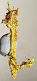
Crystalline gold from the Nightingale District

