Nippletop (Zion) facts for kids
Quick facts for kids Nippletop |
|
|---|---|

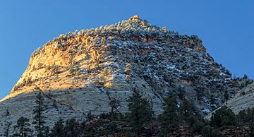
North-northeast aspect, from Zion – Mount Carmel Highway
|
|
| Highest point | |
| Elevation | 6,715 ft (2,047 m) |
| Prominence | 795 ft (242 m) |
| Isolation | 0.74 mi (1.19 km) |
| Parent peak | Crazy Quilt Mesa (6,760 ft) |
| Geography | |
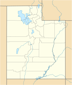
| Location | Zion National Park Washington County, Utah< United States |
| Parent range | Colorado Plateau |
| Topo map | USGS Springdale East |
| Geology | |
| Age of rock | Jurassic |
| Type of rock | Navajo sandstone |
| Climbing | |
| Easiest route | class 2+ scrambling |
Nippletop is a tall, white mountain in Zion National Park, Utah. It stands 6,715 feet (about 2,050 meters) high. This mountain is made of a type of rock called Navajo Sandstone. You can find Nippletop in Washington County, in the southwestern part of Utah, United States.
Nippletop is located about one mile west of Crazy Quilt Mesa. It is also one mile south of the Zion – Mount Carmel Highway. The mountain rises sharply, towering 1,200 feet (365 meters) above the highway. Rain and snow that fall on Nippletop flow into small streams. These streams then join the Virgin River.
Weather Around Nippletop
The best times to visit Nippletop are during spring and fall. The weather is usually very pleasant then. The area has a special kind of dry climate. It is called a cold semi-arid climate. This means that the coldest month of the year has an average temperature below 32 °F (0 °C). Also, more than half of the yearly rain happens in spring and summer.
This desert climate does not get much rain. It receives less than 10 inches (250 mm) of rain each year. Snowfall is usually light during the winter months.
 | Toni Morrison |
 | Barack Obama |
 | Martin Luther King Jr. |
 | Ralph Bunche |


