
Norah Head facts for kids
Quick facts for kids Norah HeadCentral Coast, New South Wales |
|||||||||||||||
|---|---|---|---|---|---|---|---|---|---|---|---|---|---|---|---|

Norah Head lighthouse, located on the headland
|
|||||||||||||||

Norah Head
Location in New South Wales
|
|||||||||||||||
| Postcode(s) | 2263 | ||||||||||||||
| Elevation | 3 m (10 ft) | ||||||||||||||
| Location |
|
||||||||||||||
| LGA(s) | Central Coast Council | ||||||||||||||
| Parish | Wallarah | ||||||||||||||
| State electorate(s) | Wyong | ||||||||||||||
| Federal Division(s) | Dobell | ||||||||||||||
|
|||||||||||||||
Norah Head, originally known as Bungaree Noragh Point, is a beautiful coastal village in New South Wales, Australia. It's part of the Central Coast Council area.
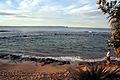
Norah Head is famous for its amazing surfing spots and clear beaches. You can visit places like Soldiers Beach, which is close to Wyrrabalong National Park. There's also Pebbly Beach, home to the cool Norah Head Rock Pool. The village is also known for its historic Norah Head Lighthouse, which offers fantastic views of the coast.
Contents
Norah Head Lighthouse: A Coastal Guide
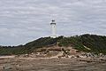
The Norah Head Lighthouse was the last big lighthouse built in New South Wales. It's a tall tower, about 63 meters high, and was finished in 1903. It was built because many ships had accidents near the coast here.
How the Lighthouse Works
When it was first built, the lighthouse used a special kerosene lamp. Even today, it has a large Fresnel lens prism that floats on a pool of mercury. This helps the light shine far. At first, weights made the prism spin. But in 1961, it became electric, and by 1995, it was fully automatic.
The light flashes once every 15 seconds. You can see it from about 27 nautical miles away. The main light is 46 meters above sea level. For ships closer to the coast, there are two other lights. A red light shines to the northeast, and a green light shines to the southwest.
Stay at the Lighthouse Cottages
The old homes where the lighthouse keepers used to live are still there. These include the Head Keeper's cottage and two semi-detached homes for assistants. Two of these cottages are available for people to rent, offering a unique place to stay. The lighthouse is also a popular spot for weddings!
Historical Sites in Norah Head
Norah Head has some important historical places. These are known as heritage-listed sites.
- Bush Street: Norah Head Lightstation Precinct
Norah Head During World War II
During World War II, some sea battles happened near Norah Head. The Japanese Navy and Merchant navy ships were involved.
Sadly, three ships were sunk here:
- The Nimbin, a ship weighing 1052 tonnes, sank on December 5, 1940, because of a mine.
- The fishing trawler Millimumul sank on March 26, 1941. Seven men lost their lives when it hit a German mine.
- The Iron Chieftain, a ship weighing 4812 tonnes, was sunk by a submarine on June 3, 1942. Another ship, the Age, was also attacked that same day.
Amazing Geology of Norah Head
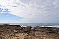
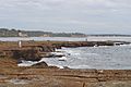
Norah Head has some really cool and unique landforms. Right in front of the headland, there's a large rock platform. This platform formed a very long time ago, between 180 and 280 million years ago!
Volcanic Rock Formations
In the rock platform, you can see a dark channel of rock running through it. This is called a volcanic intrusion. It was created when waves carved out softer basalt lava from the surrounding granite rock. This lava came from an ancient volcano, possibly Mount Warrawolong, which is to the west.
Norah Head Weather Overview
| Climate data for Norah Head, New South Wales (1989–2022) | |||||||||||||
|---|---|---|---|---|---|---|---|---|---|---|---|---|---|
| Month | Jan | Feb | Mar | Apr | May | Jun | Jul | Aug | Sep | Oct | Nov | Dec | Year |
| Record high °C (°F) | 44.0 (111.2) |
39.7 (103.5) |
37.2 (99.0) |
33.6 (92.5) |
28.1 (82.6) |
26.3 (79.3) |
24.7 (76.5) |
29.4 (84.9) |
33.5 (92.3) |
36.5 (97.7) |
41.5 (106.7) |
40.7 (105.3) |
44.0 (111.2) |
| Mean daily maximum °C (°F) | 26.3 (79.3) |
26.1 (79.0) |
25.2 (77.4) |
23.2 (73.8) |
20.3 (68.5) |
18.0 (64.4) |
17.5 (63.5) |
18.9 (66.0) |
21.2 (70.2) |
22.8 (73.0) |
23.9 (75.0) |
25.1 (77.2) |
22.4 (72.3) |
| Mean daily minimum °C (°F) | 19.8 (67.6) |
20.0 (68.0) |
18.9 (66.0) |
16.1 (61.0) |
13.1 (55.6) |
11.1 (52.0) |
9.8 (49.6) |
10.5 (50.9) |
12.8 (55.0) |
14.9 (58.8) |
16.8 (62.2) |
18.5 (65.3) |
15.2 (59.4) |
| Record low °C (°F) | 14.5 (58.1) |
13.9 (57.0) |
12.0 (53.6) |
7.9 (46.2) |
6.9 (44.4) |
5.3 (41.5) |
4.0 (39.2) |
4.6 (40.3) |
6.1 (43.0) |
8.5 (47.3) |
8.8 (47.8) |
11.2 (52.2) |
4.0 (39.2) |
| Average precipitation mm (inches) | 80.6 (3.17) |
122.8 (4.83) |
136.5 (5.37) |
120.9 (4.76) |
124.1 (4.89) |
154.4 (6.08) |
84.8 (3.34) |
69.9 (2.75) |
61.5 (2.42) |
63.9 (2.52) |
94.1 (3.70) |
70.4 (2.77) |
1,163.9 (45.82) |
| Average precipitation days | 12.5 | 12.7 | 14.5 | 14.1 | 13.4 | 14.3 | 10.8 | 8.9 | 11.3 | 11.3 | 12.5 | 12.0 | 148.3 |
| Average relative humidity (%) | 70 | 72 | 69 | 65 | 64 | 63 | 59 | 56 | 60 | 64 | 68 | 68 | 65 |
| Source: Bureau of Meteorology | |||||||||||||
Images for kids
-
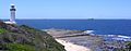
Panoramic view of the Norah Head Lighthouse.
-
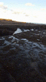
Wild waves often crash at Norah Head.
-
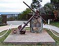
A memorial for the Merchant Navy.
-
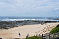
A beautiful beach near Norah Head.
-
The unique rock platform off Norah Head.
-
Looking back at the lighthouse from the rock platform.
-
Fishing is a popular activity at Norah Head.
-
The Norah Head rockpool during high tide.


