
Norlane, Victoria facts for kids
Quick facts for kids NorlaneGeelong, Victoria |
|||||||||||||||
|---|---|---|---|---|---|---|---|---|---|---|---|---|---|---|---|

Ford stamping plant on the Princes Highway, 2009
|
|||||||||||||||
| Population | 8,306 (2016 census) | ||||||||||||||
| • Density | 1,629/km2 (4,220/sq mi) | ||||||||||||||
| Postcode(s) | 3214 | ||||||||||||||
| Elevation | 22 m (72 ft) | ||||||||||||||
| Area | 5.1 km2 (2.0 sq mi) | ||||||||||||||
| Location | |||||||||||||||
| LGA(s) | City of Greater Geelong | ||||||||||||||
| State electorate(s) | Lara | ||||||||||||||
| Federal Division(s) | Corio | ||||||||||||||
|
|||||||||||||||
Norlane is a suburb located north of Geelong in Victoria, Australia. It's about 7 kilometres from Geelong's city centre and around 70 kilometres from Melbourne, the state capital. Norlane is also close to the water, being only about one kilometre from Corio Bay. In 2016, about 8,300 people lived in Norlane.
Contents
A Glimpse into Norlane's Past
Norlane got its name from Norman Lane, a local serviceman. He sadly passed away in 1943 while working on the Thai-Burma Railway after being captured in Singapore during World War II.
The Norlane post office first opened its doors on 17 December 1945, which was around the time the suburb started to grow. Later, the Norlane West post office opened in 1958.
How Norlane Grew: Housing for Workers
After World War II, many people needed places to live, especially in the early 1950s. The Housing Commission of Victoria helped by building homes for families who couldn't afford to rent or buy their own houses.
In 1947, the government's Housing Commission started building houses in Norlane. By 1976, they had built 2,464 homes for people with lower incomes. Many of these houses were for workers at big factories nearby, like Ford Motor Company, International Harvester, Shell, and others.
Workers, including many migrants building new lives, came to Geelong for jobs. The Victorian Government responded by buying large areas of land north of the Ford factory and building hundreds of homes. Some of these houses were even built in the Netherlands and France and then brought to Australia! In just ten years, Norlane changed from empty fields to a busy suburb where many working-class families lived. By 1960, the streets and roads we see today stretched all the way to Corio Village. It was an exciting time for Geelong!
Important Historical Sites
One important historical site in Norlane is the Ford Motor Company Complex on the Princes Highway. It's listed on the Victorian Heritage Register, which means it's a place with special historical importance.


Who Lives in Norlane?
In 2001, about 8,600 people lived in Norlane. Slightly more females lived there than males. About a quarter of the people living in Norlane were born outside of Australia. The most common age group was 40-49 years old.
Homes in Norlane
Most homes in Norlane are separate houses, but there are also flats, apartments, and semi-detached houses. Many older homes built in the 1960s are single-story houses with big backyards. More recently, new brick houses and two-story homes are becoming more common.
Because Norlane offers affordable housing, many people look to rent homes here. In 2018, the average price for a three-bedroom house was around $350,000.
Jobs and Community
Many Norlane residents work in engineering, management, commerce, and food or hospitality industries.
Norlane has several churches, showing the different religious backgrounds of its residents. In 2001, the main religious groups were Catholic, Anglican, Orthodox, Presbyterian, and Uniting.
What Can You Do in Norlane?
Norlane is a popular place to live because it has affordable housing, shops, transport, and jobs nearby.
Fun and Shopping
Norlane's Waterworld is a great place for swimming and fun! It has two indoor heated swimming pools, a spa, a gymnasium, two water slides, a diving pool, and outdoor pools for kids.
Labuan Square shopping centre opened in 1954, offering convenient shopping for residents. While the bigger Corio Shopping Centre is now nearby, Labuan Square and other smaller shops still serve the community.
Parks and Outdoors
There are three boat ramps close by: Corio Bay Boat Club, Grammar School Lagoon Boat Ramp, and St Helens Boat Ramp. Norlane also has seven parks, covering almost 9% of its total area. These parks have ovals and facilities for skating and ball games, perfect for outdoor activities.
Learning in Norlane: Schools
Many primary schools opened in Norlane between 1955 and 1962, and Norlane High School opened in 1959. Over time, some schools have changed. Norlane Primary School closed in 2004, and Norlane High School closed in 2012.
Now, most primary and secondary students attend Northern Bay P-12 College. This is a large college with multiple campuses that was formed in 2011 by combining nine different schools. Other schools in the area include St Thomas Aquinas Primary School and Geelong Kindergarten Association.
Getting Around Norlane

Most people in Norlane use cars to get around, but walking and cycling are also common. The Princes Highway, also known as Melbourne Road, is a major road that goes through the middle of Norlane. It connects Melbourne and Geelong. The Geelong-Bacchus Marsh Road also provides access to central Victoria.
North Shore railway station is located at the south-east edge of Norlane. From here, you can catch V/Line trains on the Geelong line to both Melbourne and Geelong.
How Norlane's Population Has Changed
Here's a look at how Norlane's population has changed over the years:
- 1947 – 347 people
- 1971 – 12,098 people
- 2001 – 8,616 people
- 2006 – 7,935 people
Images for kids
-
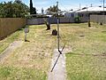
The backyard of a typical 750m² lot
-
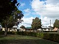
A typical front yard and street-scape
-
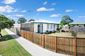
A typical 3-bedroom house in Norlane
-
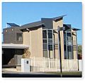
New-style public housing


