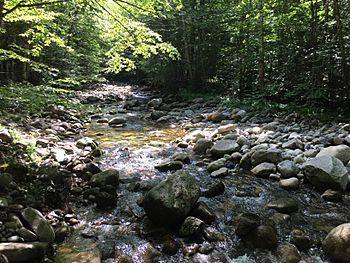
North Branch Gale River facts for kids
Quick facts for kids North Branch Gale River |
|
|---|---|

The North Branch, south of U.S. Route 3
|
|
| Country | United States |
| State | New Hampshire |
| County | Grafton |
| Towns | Franconia, Bethlehem |
| Physical characteristics | |
| Main source | Galehead Mountain, South Twin Mountain Franconia 3,720 ft (1,130 m) 44°11′27″N 71°33′50″W / 44.19083°N 71.56389°W |
| River mouth | Gale River Bethlehem 1,306 ft (398 m) 44°14′37″N 71°38′17″W / 44.24361°N 71.63806°W |
| Length | 5.8 mi (9.3 km) |
The North Branch of the Gale River is a small river, about 5.8 miles (9.3 kilometers) long. It flows through the beautiful White Mountains in New Hampshire, United States. This river is like a smaller stream that flows into a bigger one. It joins the Gale River, which then flows into the Ammonoosuc River. All these rivers are part of a larger area called a watershed. This means their water eventually flows into the Connecticut River.
Where the River Starts
The North Branch of the Gale River begins high up in the mountains. It starts in a valley between two peaks: South Twin Mountain and Galehead Mountain. This spot is just north of the AMC Galehead Hut, which is a shelter for hikers.
The River's Journey
From its source, the river flows mostly northwest. A hiking path called the Gale River Trail follows much of its course. The North Branch eventually meets another stream, the South Branch. Together, they form the main Gale River. This meeting point is near where the river crosses U.S. Route 3.
Through the Forest
Almost the entire North Branch flows through the White Mountain National Forest. This is a large protected area of trees and wildlife. A small part of the river passes through a reservoir. This reservoir holds water for the town of Littleton.
 | James Van Der Zee |
 | Alma Thomas |
 | Ellis Wilson |
 | Margaret Taylor-Burroughs |


