
South Twin Mountain (New Hampshire) facts for kids
Quick facts for kids South Twin Mountain |
|
|---|---|

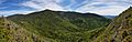
South Twin from Galehead Mountain, taken August 2009
|
|
| Highest point | |
| Elevation | 1,494 m (4,902 ft) |
| Prominence | 464 m (1,522 ft) |
| Listing | White Mountain 4000-Footers |
| Geography | |
| Location | Grafton County, New Hampshire, U.S. |
| Parent range | Twin Range |
| Topo map | USGS South Twin Mountain |
South Twin Mountain is a tall mountain located in Grafton County, New Hampshire. It's part of the beautiful Twin Range within the larger White Mountains. South Twin is a popular spot for hikers and nature lovers.
Contents
Where is South Twin Mountain?
South Twin Mountain stands as the highest point on a ridge that runs from north to south. Its close neighbor, North Twin Mountain, is about one mile north. To the southeast, you'll find Mount Guyot, about two miles away. Another mountain, Galehead Mountain, which is a bit lower, is located to the west of South Twin.
Water Flowing from the Mountain
Rain and melting snow from South Twin Mountain flow into different rivers. On the east side, water goes into the Little River. This river then joins the Ammonoosuc and later the Connecticut River. Eventually, this water travels all the way to Long Island Sound in Connecticut.
On the northwest side, water flows into the North Branch of the Gale River. This river also joins the Ammonoosuc River. To the southwest, water goes into Twin Brook. This brook flows into the Franconia Branch of the East Branch of the Pemigewasset River. This water then travels through the Pemigewasset Wilderness and into the Pemigewasset and Merrimack Rivers. Finally, it reaches the Gulf of Maine in Massachusetts.
What's the Top Like?
The very top of South Twin Mountain is open and rocky. However, nearby you'll find groups of spruce and fir trees. These trees are common in high mountain areas.
A very famous hiking path, the Appalachian Trail, crosses the summit of South Twin. This trail is super long, stretching about 2,170 miles (3,500 km)! It goes all the way from Georgia to Maine. When hikers are on South Twin, they might be coming from Galehead Mountain (and the Galehead Hut) to the west. From South Twin, the trail continues towards Mount Guyot to the southeast. There's also another trail, the North Twin Trail, which goes north along the ridge to the summit of North Twin Mountain.
Images for kids
-
A photo of South Twin Mountain taken from Galehead Mountain. North Twin Mountain can be seen in the distance to the left.
