North Fork Popo Agie River facts for kids
Quick facts for kids North Fork Popo Agie River |
|
|---|---|

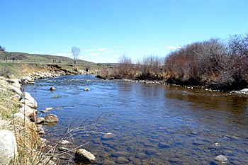
The North Fork Popo Agie River Looking east near Lander, Wy in April 2020
|
|

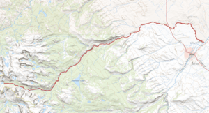
The course of the North Fork Popo Agie River
|
|
| Country | United States |
| State | Wyoming |
| Physical characteristics | |
| Main source | Lonesome Lake Wind River Range, Fremont County 10,200 ft (3,100 m) |
| River mouth | near Lander, Wyoming 5,000 ft (1,500 m) 42°51′15″N 108°41′59″W / 42.85415°N 108.69975°W |
| Length | 43 mi (69 km) |
| Basin features | |
| Tributaries |
|
The North Fork Popo Agie River is a cool river in Wyoming, USA. It helps form a natural border between the Wind River Indian Reservation and Fremont County. The river starts high up in the mountains at a place called Lonesome Lake. It then flows east until it meets another river, the Middle Fork Popo Agie River, near the town of Lander, Wyoming. The name Popo Agie comes from a Native American word that might mean "Head River" or "Gurgling River."
Fishing in the River
This river is a great spot for fishing! The Wyoming Game and Fish Department calls it a "Class 2 fishery." This means it has really good water for trout and is important for fishing across the whole state.
What Fish Can You Catch?
You can find several types of fish swimming in the North Fork Popo Agie River. These include:
Black History Month on Kiddle
African-American Artists you should know:
 | John T. Biggers |
 | Thomas Blackshear |
 | Mark Bradford |
 | Beverly Buchanan |

All content from Kiddle encyclopedia articles (including the article images and facts) can be freely used under Attribution-ShareAlike license, unless stated otherwise. Cite this article:
North Fork Popo Agie River Facts for Kids. Kiddle Encyclopedia.
