North Hutchinson Island facts for kids

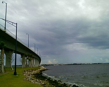
The Ernest Lyons Bridge in Sewall's Point, Florida, which carries highway A1A and connects Sewall's Point to North Hutchinson Island.
|
|
| Geography | |
|---|---|
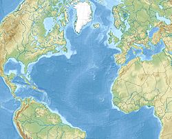
| Location | North Atlantic |
| Coordinates | 27°33′25″N 80°19′29″W / 27.55694°N 80.32472°W |
| Area | 61.8 km2 (23.9 sq mi) |
| Length | 45 km (28 mi) |
| Administration | |
| State | Florida |
| Counties | St. Lucie, Indian River |
North Hutchinson Island is a long, narrow island on the east coast of Florida in the United States. It's a special type of island called a barrier island. This means it's a strip of land that protects the mainland from ocean storms. The island is next to the Atlantic Ocean on its east side. On its west side, it's separated from the mainland by the Indian River Lagoon. Part of the island in Indian River County is also known as Orchid Island.
Contents
What is North Hutchinson Island?
North Hutchinson Island is an Atlantic barrier island located on Florida's Treasure Coast. It's about 110 miles (177 km) north of Fort Lauderdale. The island stretches from the Sebastian Inlet in the north to the Fort Pierce Inlet in the south. It is about 28 miles (45 km) long and covers an area of about 23.86 square miles (61.8 square km).
This island was once considered part of the larger Hutchinson Island to its south. However, the Fort Pierce Inlet naturally divided it into two separate islands. In 1985, the part of the island in Indian River County was given a new name, "Orchid Island". This was done to show that it was different from the more developed areas of Hutchinson Island in St. Lucie County.
State Road A1A is the main road that runs along the entire length of the island. This road is often called Atlantic Beach Boulevard. Four bridges connect the island to the mainland, making it easy to get around. North Hutchinson Island is known for its many county and state parks. It's also one of the few places on Florida's east coast where the beaches are actually growing, not shrinking!
You can find many restaurants, hotels, and shops on or near the island. There are lots of fun activities to do here. These include fishing, snorkeling, boating, kayaking, hiking, and biking. You can also try surfing, parasurfing, and paddleboarding. It's a great place to watch wildlife too. The northern end of the island is home to Pelican Island National Wildlife Refuge. This was the first wildlife refuge in the United States, created by President Theodore Roosevelt in 1903. It protects over 5,400 acres (22 square km) of water and land. Avalon State Park is another great spot on A-1-A. Its beach is popular for swimming, snorkeling, surfing, and scuba diving. The island's natural environment is home to many animals. You might see manatees, dolphins, sea turtles, various fish, and many kinds of birds.
Towns and Cities on the Island
The city of Vero Beach is located on both sides of the Indian River. Its main business and living areas are on the mainland. Two of the four bridges connecting the island to the mainland are within Vero Beach. Other communities found on North Hutchinson Island include:
- The towns of Indian River Shores and Orchid.
- The census-designated places (areas that are like towns but not officially incorporated) of South Beach, Wabasso Beach, and Windsor.
Cool Parks and Nature Spots
North Hutchinson Island has many beautiful parks and protected areas where you can enjoy nature.
- Avalon State Park: This park is about 4 miles (6.4 km) north of Fort Pierce Inlet State Park.
- Fort Pierce Inlet State Park: A popular spot for beach activities and enjoying the inlet.
- Sebastian Inlet State Park: Located at the very north end of Orchid Island. It even extends into Brevard County.
- Jack Island State Preserve: Found on the west side of A-1-A, north of Pepper Park Beachside.
- Archie Carr National Wildlife Refuge: Located on the northern part of the island. This refuge was created specifically to protect sea turtles.
- Pelican Island National Wildlife Refuge: This important wildlife refuge is in the Indian River Lagoon, north of Windsor.
- Pepper Park Beachside: A St. Lucie County park on the southern end of North Hutchinson Island along A-1-A. It has fishing piers and public beach access with picnic areas.
- Riverside Park: An Indian River County park located at the foot of the Merrill Barber Bridge on the island side. This park is home to the Vero Beach Art Museum, the Riverside Theatre, and the Riverside Children's Theatre.
- Round Island Park: An Indian River County park that borders the county line to the south. It stretches from the ocean to the river.
Fun Places to Visit
There are several interesting places to visit on or near North Hutchinson Island:
- In Sebastian Inlet State Park, you can find:
- McLarty Treasure Museum: Learn about treasures from old shipwrecks.
- Site of camp used by survivors and salvagers of the wrecks of the 1715 Spanish Treasure Fleet. This was a camp used by people who survived and salvaged items from Spanish ships that sank in 1715.
- Sebastian Fishing Museum: Discover the history of fishing in the area.
- National Navy UDT-SEAL Museum: This museum is on the east side of A-1-A, just south of Pepper Park Beachside. It tells the story of the Navy's special forces.
- The Driftwood Inn and Waldo's Restaurant: This historic building is listed on the National Register of Historic Places. It's located at Sexton Park right on the Atlantic Ocean.
- Disney's Vero Beach Resort: A fun resort located in Wabasso Beach.


