North Mankato, Minnesota facts for kids
Quick facts for kids
North Mankato, Minnesota
|
|
|---|---|

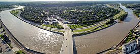
The bridge on Belgrade Ave in North Mankato
|
|

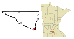
Location of North Mankato, Minnesota
|
|
| Country | United States |
| State | Minnesota |
| Counties | Nicollet, Blue Earth |
| Metro | Mankato–North Mankato |
| Founded | 1857 |
| Incorporated | December 19, 1898 |
| Government | |
| • Type | Mayor–Council |
| Area | |
| • City | 6.551 sq mi (16.967 km2) |
| • Land | 6.437 sq mi (16.672 km2) |
| • Water | 0.114 sq mi (0.296 km2) |
| Elevation | 994 ft (303 m) |
| Population
(2020)
|
|
| • City | 14,275 |
| • Estimate
(2023)
|
14,091 |
| • Density | 2,189.06/sq mi (845.20/km2) |
| • Urban | 57,584 (US: 456th) |
| • Metro | 104,248 (US: 352nd) |
| Time zone | UTC–6 (Central (CST)) |
| • Summer (DST) | UTC–5 (CDT) |
| ZIP Codes |
56002, 56003
|
| Area code(s) | 507 and 924 |
| FIPS code | 27-47068 |
| GNIS feature ID | 2395257 |
| Sales tax | 7.875% |
North Mankato (/mænˈkeɪtoʊ/ man-KAY-toh) is a city in Minnesota, United States. It is mostly located in Nicollet County, with a small part in Blue Earth County. In 2020, about 14,275 people lived there.
North Mankato is right across the Minnesota River from Mankato. Together, these two cities form the Mankato-North Mankato area, which has a total population of over 58,000 people. North Mankato is the smaller of these two main cities.
The city was officially started as a village on December 19, 1898. Important roads like U.S. Highway 14, U.S. Highway 169, and Minnesota State Highway 60 pass through North Mankato.
Contents
Where is North Mankato?
North Mankato is located at about 44.18 degrees North latitude and 94.03 degrees West longitude.
The city covers a total area of about 6.55 square miles (16.97 square kilometers). Most of this area, about 6.44 square miles (16.67 square kilometers), is land. The rest, about 0.11 square miles (0.30 square kilometers), is water.
How Many People Live Here?
| Historical population | |||
|---|---|---|---|
| Census | Pop. | %± | |
| 1900 | 939 | — | |
| 1910 | 1,279 | 36.2% | |
| 1920 | 1,840 | 43.9% | |
| 1930 | 2,822 | 53.4% | |
| 1940 | 3,517 | 24.6% | |
| 1950 | 4,788 | 36.1% | |
| 1960 | 5,927 | 23.8% | |
| 1970 | 7,347 | 24.0% | |
| 1980 | 9,145 | 24.5% | |
| 1990 | 10,164 | 11.1% | |
| 2000 | 11,798 | 16.1% | |
| 2010 | 13,394 | 13.5% | |
| 2020 | 14,275 | 6.6% | |
| 2023 (est.) | 14,091 | 5.2% | |
| U.S. Decennial Census 2020 Census |
|||
In 2022, there were about 5,923 homes in North Mankato. On average, about 2.38 people lived in each home. The average income for a household was around $74,602.
Most people in North Mankato are employed, with about 72.3% of the population working. A large number of adults, about 97.5%, have a high school diploma. Also, about 43.3% of the people have a college degree or higher.
The average age of people living in North Mankato is about 37.4 years old.
Population in 2020
According to the 2020 census, North Mankato had 14,275 residents. There were 5,877 households and 3,647 families living in the city.
Most of the people in North Mankato, about 85.9%, were White. Other groups included about 5.6% African American people and 1.7% Asian people. About 4.2% of the population identified as Hispanic or Latino.
About 25.4% of the residents were under 18 years old. About 16.6% were 65 years old or older. The city had slightly more females (51.9%) than males (48.1%).
Population in 2010
In the 2010 census, North Mankato had 13,394 people. There were 5,580 households and 3,553 families.
About 93.9% of the people were White. Other groups included about 2.1% African American people and 1.7% Asian people. About 3.0% of the population identified as Hispanic or Latino.
The average age in 2010 was 35.5 years. About 23.7% of residents were under 18. About 11.9% were 65 or older. The city had slightly more females (50.7%) than males (49.3%).
Schools and Learning
North Mankato has several schools for students of all ages.

Public Schools
- Bridges Community School
- Dakota Meadows Middle School
- Futures Program
- Futures Sun
- Hoover Elementary School
Colleges and Universities
- South Central College is a place where older students can go for more education after high school.
Local Businesses
North Mankato is home to some important companies:
- Angie's Artisan Treats: This company makes tasty snacks like kettle corn.
- Taylor Corporation: This is a large company that provides many different business services.
See also
In Spanish: North Mankato (Minnesota) para niños

